Reaching the peaks of the Wyoming Absarokas often requires a multi-day approach. There are, however, a few areas that offer day-trip access to excellent mountains on the edge of or already amidst some serious wilderness. These mountains tend to make poor objectives for technical climbing, but they constitute a paradise for hikers and scramblers.
Enter the Kirwin area of the southeastern Absarokas. Kirwin is both an area and a trailhead, and the purpose of this page is to collect and introduce the peaks in this special area of this very special range.
Scattered throughout the Rockies are a few great trailheads, here defined as places that are high and which offer relatively short access to several great alpine destinations. They are perfect for people like me who will don the backpack if necessary but who really prefer steep but straightforward day hikes and climbs. Colorado has Yankee Boy Basin, which, at 12,600’ at the end of a 4WD road from Ouray, has routes to Blue Lakes Pass, Kismet Peak, Mount Gilpin, and, above all, Mount Sneffels. Montana has Logan Pass, where there are routes to several of Glacier National Park’s most beautiful and recognizable peaks. Wyoming has the Sugarloaf Recreation Area, another timberline trailhead that gives birth to all kinds of destinations within the Snowy Range. Other similar alpine entryways exist, but these are three of my favorites.
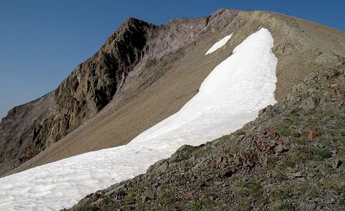
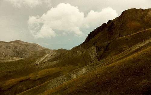
Mount Crosby
But Wyoming has another, greater trailhead--- Kirwin. Kirwin was once the site of a mining town, and remaining buildings and other relics attract visitors, but it is also the gateway to some characteristically big and spectacular Wyoming country. The trailhead is not as high (9200’) relative to timberline as the aforementioned trailheads are, and the drive there, though scenic, does not compare to the Yankee Boy Basin road, Going-to-the-Sun Road, or the Snowy Range Scenic Byway, but it is the heart of several arteries pulsing their ways into some of the highest parts of Wyoming’s wild, spectacular Washakie Wilderness in the Absaroka Range. On my Yellowstone Ecosystem page, there’s enough gushing about the Absarokas already, so here I’ll just say that this range has everything I seek in the mountains—deep ruggedness; the remoteness and vastness of true wilderness; dark peaks that tower and brood over the wonderland that is Wyoming and which are in places painted with the coloration common to mountains of volcanic origin; easily obtainable solitude; and the iconic grizzly bear and gray wolf. This range is my favorite among favorites, and my unsolicited opinion holds that the culminating effect of its many appealing traits is to make it a range without equal.
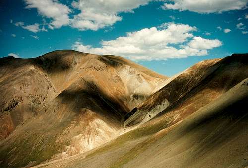
Spar Mountain
There are five fine trail destinations, all of them alpine passes, from Kirwin, three of which I personally know are reached by maintained trails (but the trails often become faint as they wind up and through the meadows above timberline). Maps show trails to the other two, but I have not hiked them and cannot attest to their upkeep. Be smart and carry a good topo map, compass, and sense of direction no matter what trail you take out here.
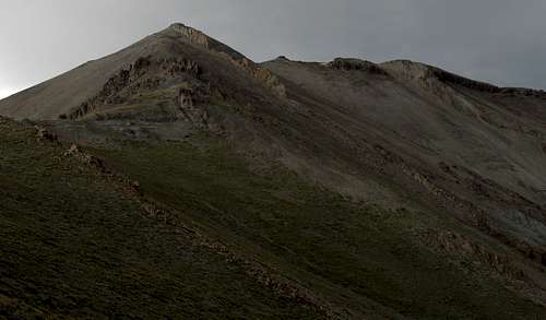
Brown Mountain
First, some words about the destinations I have not visited—- The Cascade Creek Trail climbs to an 11,340’ pass that is unnamed on any of my maps. Just call it Cascade Creek Pass for our purposes here and know that it takes about five miles of hiking to reach the pass. The other is Horse Creek Pass, which is at about 11,200’. At about six miles from Kirwin, it is one of the most remote from the trailhead of all the passes reached from it.
Greybull Pass
Now for those I do know—- Bear Creek Pass, at 11,211’, requires about six miles of hiking to reach. Although the entire area has a wild, remote feel, it seemed the most so at Bear Creek Pass, where I felt about as far from the “civilized,” mechanized world as one could possibly be. East Fork Pass, at 11,171’, is about five miles from the trailhead, and the trail also passes a small, narrow gorge near treeline. Greybull Pass, my scenic favorite of the three, is just three miles from the trailhead. Its elevation is about 11,480’.
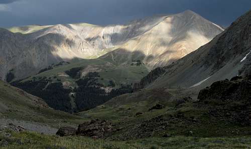
View from East Fork Pass
There was decent signage when I hiked in this area in 2001 and 2007, but I was glad to have a good map with me. Don’t count on good signage. And remember—the trails become faint in the meadows above treeline. Up there, the country is so big and open that it’s hard to get truly lost, but a good topo map and the ability to use it make a good insurance policy out here.
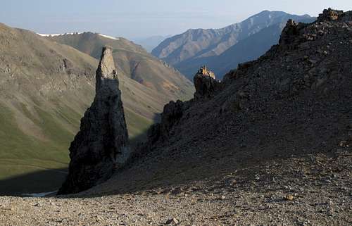
View from Bear Creek Pass
Know also that this is prime grizzly country. Before you journey into these mountains, make sure you know the proper etiquette for grizzly country.
Getting There
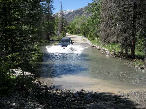
River crossing-- photo by musicman82 of Bob Sihler driving through
You will have to drive to the Kirwin trailhead. 4WD is recommended, but high clearance and AWD will suffice under most warm-weather conditions. Kirwin was a mining boomtown many years ago, and several structures still remain in the area. The ruined townsite is a popular destination for locals who like to drive up for lunch and a tour, but few people outside the area know anything about Kirwin and the awesome trail system it accesses. Kirwin is also one of the most beautiful trailheads in the Rockies, with towering, brooding mountains all around it.
From Meeteetse, 32 miles south of Cody, turn west onto the signed road for Wyoming 290. In 6.4 miles, turn left onto Wood River Road. At 11.6 miles, the pavement ends. The national forest boundary is at 21.7 miles. Pass Wood River Campground at 22.4 miles and Brown Mountain Campground at 24.8 miles. The road now gets a little rougher, but it is not real 4WD stuff. At 26.8 miles is the first of four stream crossings. This one is short and usually shallow. The second river crossing is at 27 miles. This one is wider and deeper. The third crossing, which is actually two crossings in quick succession, is at 29.3 miles. These are broad but shallow. The last two miles to the trailhead are rocky but not anything to get nervous about. There is one more stream crossing just before the trailhead, but it is a tributary stream and may even be dry. The trailhead is at 33.1 miles (in another vehicle, I got 34 miles). It took me 75 minutes to make the drive.
NOTE: In late spring, early summer, and after storms, the stream crossings could be difficult or dangerous, so get out and test them before you plow through. I have made it through in a Subaru Outback, but the crossings on the way out were a little sketchy for that car, as the stream was swollen with the previous night’s rain.
Also, conditions can change. In 2010, there were water crossings that were not there during my visits in 2001 and 2007. Be prepared for a driving adventure.
Ghost town-- by musicman82
Red Tape and Camping
Red Tape
This is prime grizzly country, which means special rules about food storage and personal behavior are in order. I will not list them all here. Bottom line: If you don’t know, don’t go.
Road construction may affect access. It would be wise to check with the local ranger district about any access restrictions before heading in. Call 307-868-2379 (Meeteetse Ranger District).
Camping
Camping is available at the Wood River and Brown Mountain Campgrounds (see Getting There about directions). The sites go on a first-come, first-served basis, and there is a $10 camping fee. Water and pit toilets are available at both.
You could also sleep in your car at or near the trailhead.
More Information
It's a long drive to Kirwin. It would be wise to check with the local ranger district about any access restrictions before heading in. Call 307-868-2379 (Meeteetse Ranger District).
Children refers to the set of objects that logically fall under a given object. For example, the
Aconcagua mountain page is a child of the 'Aconcagua Group' and the 'Seven Summits.' The
Aconcagua mountain itself has many routes, photos, and trip reports as children.
Parents refers to a larger category under which an object falls. For example, theAconcagua mountain page has the 'Aconcagua Group' and the 'Seven Summits' asparents and is a parent itself to many routes, photos, and Trip Reports.

 26406 Hits
 87.76% Score
 25 Votes