
|
|
Area/Range |
|---|---|
|
|
40.76528°N / 105.70667°W |
|
|
Hiking, Mountaineering, Bouldering, Scrambling |
|
|
Spring, Summer, Fall, Winter |
|
|
Overview
 Middle Bald Mountain
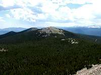
The Bald Mountains are a cluster of mountains in the southern part of the Laramie Range in north-central Colorado. They consist of the three highest named peaks of the Laramie Range, plus several nearby unnamed peaks. The three named peaks are from highest to lowest: 11,003' South Bald Mountain, 11,002' Middle Bald Mountain, and 10,982' North Bald Mountain. As you might expect, the peaks are so named for their predominantly bald tops that jut just above timberline. The peaks are located in the Canyon Lakes District of Roosevelt National Forest.
 "West Bald Mountain"
An interesting fact is that the highest peak of the Bald Mountains (and Laramie Range) is an unnamed peak that isn't even given an elevation on USGS Topo Maps. The peak is measured at 11,020 feet (Lists of John) and is located at 40.77033 N, 105.71605 W. It is also the 95th most prominent peak in Colorado, according to Lists of John, with a rise of 1880 feet. I would like to suggest calling this peak "West Bald Mountain."
Other unnamed peaks of the Bald Mountains are:
Unnamed Peak 10,895' (40.77607 N, 105.73311 W)
Unnamed Peak 10,884' (40.74399 N, 105.68178 W) *aka "Southeast Bald Mountain"
Unnamed Peak 10,775' (40.74547 N, 105.69034 W)
Unnamed Peak 10,670' (40.75770 N, 105.70250 W)
Unnamed Peak 10,546' (40.74566 N, 105.67379 W)
This is an unofficial list. There are other unnamed peaks in the area that are not "bald", therefore I have chosen not to list them here.
Getting There
 South Bald Mountain
There are numerous ways of getting here. Five of the most common are:
1) From the Killpecker Trailhead on Deadman Road
2) From the North Lone Pine Trailhead on Deadman Road
3) From the Swamp Creek Cutoff Trail via Manhattan Road (CR 162) to NF 171 to NF 171C
4) From the rugged Killpecker Road (NF 300)
5) From the very rugged Elkhorn Baldy Road (NF 517)
For more detailed directions, see the "Getting There" descriptions for South Bald Mountain and Middle Bald Mountain
Red Tape
 North Bald Mountain
Camping
These peaks are in multi-use national forest. Contact the US Forest Service for the most current information on camping regulations.
External Links
For photo albums for hikes to five of these peaks, see:South Bald Mountain
North, Middle and "West" Bald Mountains
"Southeast Bald Mountain" (10,884')
Want to Contribute?
Anyone is welcome to contribute. Just let me know what you want added to the description, and I will likely add it for you. Thanks!Seasonal Information
Possible Forest Service access roads in the area are:Deadman Road as far as Pearl Beaver Road
Killpecker Road (NF 300)
Bald Mountain Road (NF 517)
For the most up-to-date information on road openings and closures, visit the US Forest Service Road Conditions Website.
tarol - Dec 27, 2006 4:38 pm - Voted 10/10
Good pageJust a little suggestion... Change National Forest Service to US Forest Service.
joegrim - Jan 2, 2007 1:41 am - Hasn't voted
Thank youThank you. I've made the change you suggested.