
-
 18120 Hits
-
 86.37% Score
-
 22 Votes
|
|
Area/Range |
|---|---|
|
|
39.45442°N / 105.09152°W |
|
|
Hiking |
|
|
Spring, Summer, Fall, Winter |
|
|
7160 ft / 2182 m |
|
|
Overview
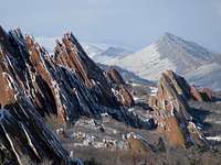

Roxborough State Park offers spectacular red rock formations and an abundant wildlife right outside Denver.
Its dramatic landscape made it the only state park to be designated by the U.S. Department of the Interior as a National Natural Landmark. It was Colorado's first state park to be designated as a State Natural Area, and it is a National Archeological District.
The park area raises from the last/first rollig hills of the prairie at 5900 feet(whatever your perspective is) up to the summits of the very first peaks of the Front Range at 7160 ft.
Being located in the transition zone between the plains and the moutains, makes the park extremely ecologically diverse.
Mountain lion, black bear, bobcat, mule deer and foxes call the 3339 acres park acres their home.
145 bird species have been reported in the last 20 years in the park - from hummingbirds to golden eagles - 42 species nest in the park.
11 species of amphibians and reptiles - including the Western Rattlesnake -can be found in the park area.
The area's geological structure resulted in a microclimate, which produced seven distinct plant communities - including grasslands, large patches of oak scrub and stands of Douglas fir in the ravines of higher elevations.
Getting There


From WADSWORTH AVENUE
Take Wadsworth south past Chatfield State Park. Turn left on Waterton Road (just before the entrance to Lockheed Martin.) Continue on Waterton Road—crossing the South Platte River, until it ends at North Rampart Range Road (1.6 miles) Turn right (south) on North Rampart Range Road. Continue south past Roxborough Village and the Foothills Water Treatment Plant. (2.3 miles) At the intersection of North Rampart Range Road and Roxborough Park Road (just before the entrance to Arrowhead golf course), turn left onto Roxborough Park Road. Take the next right (about 50 yards away) to enter the park.
From SANTA FE / HIGHWAY 85
From Denver head south on Santa Fe (Highway 85) to Titan Road. (4.2 miles south of C-470 intersection) Turn right (west) on Titan Road. Continue heading west on Titan Road. It will curve and begin to head south—becoming North Rampart Range Road (3 miles). Continue south on North Rampart Range Road past Roxborough Village and the Foothills Water Treatment Plant (3.5 miles). At the intersection of North Rampart Range Road and Roxborough Park Road, turn left onto Roxborough Park Road. Take the next right (about 50 yards away) to enter the park
Hiking


Hikers have to stay on established trails - please abide to this regulation!
Roxborough State Park offers four trails. Only one is leading up to an actual peak, the other ones stay in the lower reaches of the park allowing you to get close up views of the rock formations and enjoy the wildlife of the park.
Roxborough State Park Trail Map
Fountain Valley Loop Trail (Fountain Valley and Lyons Overlook)
Total distance: 2.3 miles
Loop that winds through the Fountain and Lyons rock formations, with short side trails to the Fountain Valley and Lyons Overlooks.
South Rim Trail
Total distance: 3.0 miles
Scrub oak stands, grassy meadows, cottonwoods and other riparian habitats. Hiking along the rocky outcrops of the Dakota Hogback gives you a northern view of the Fountain, Lyons and Dakota formations.
Willow Creek Trail
Total distance: 1.4 miles
Trail through scrubs of oak and meadows. Lots of wild flowers and birds.
Carpenter Peak
Carpenter Peak
Total distance: 6.4
Elevation: 7,160 (at peak)
6.4 mile round-trip hike of moderate-to-steep terrain. Its summit is the highest point in the park and provides a spectacular view in all directions. The .07-mile Elk Valley Link near the beginning of the Carpenter Peak trail connects to the Douglas County Trail System via Douglas County Road 5.
Mountain conditons

Park can be visited year round.
Only on a sunny day the rocks will show their most intense redish color
Summer temperatures can raise above 100 F, winter temperatures can drop far below 0 F.
Powerful thunderstorms hit the Front Range on a regular basis in Summer and early Fall.
Snowfall in the State Park area can be considerably higher than in the Metro Denver area.
Plenty of posion ivy and rattlesnakes in the park.
Red Tape


Help to preserve this gem for the next generation!
STAY ON ESTABLISHED TRAILS
NO ROCKCLIMBING
NO Pets - your "best friend" would cause lots of stress to the mule deer herds and other animals in the park
NO horseriding or bicycling
NO camping
You must have a valid Colorado State Park Pass or pay for a daily park pass ($6 as of 2010).
Opening hours vary each month, but generally park is open in winter from 8 am to 5 pm and in summer from 7 am to 9 pm.
PARK GATE IS CLOSED AFTER END OF OPENING HOURS
Accomodation / Camping


Denver and its suburbs offer plenty of hotels and motels for any price range
Camping:
Closest Campsites:
Chatfield State Park Camping
Pike National Forest South Platte Ranger District
Pike National Forest Pike's Peak Ranger District
Links


Official Website of Roxborough State Park
Park Office
4751 North Roxborough Dr
Littleton, CO 80125
Phone 303-973-3959
roxborough.park@state.co.us