|
|
Mountain/Rock |
|---|---|
|
|
45.21320°N / 119.2946°W |
|
|
Morrow |
|
|
Hiking |
|
|
Spring, Summer, Fall, Winter |
|
|
5932 ft / 1808 m |
|
|
Morrow County Highpoint - Overview
Black Mtn. is the county highpoint of Morrow County and as such, warrants a visit from that group of peakbaggers known as county highpointers. The unique thing about a county highpoint is that each and every one is important if you intend to complete all of the 36 in the state of Oregon. Oregon certainly has loftier and more impressive ones such as Mt. Hood, Mt. Jefferson and Mt. McLoughlin, but there are a few like this mountain that are special in their own right.
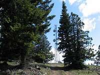
The main negative about Black Mountain and the aspect of it that will cause some to denigrate it as a mountain of any importance (other than being a county highpoint) is the fact that modern civilization decided that its lofty position in Morrow County should make it serve as a place to stick communication towers. Therefore a road was built to the summit and antennas and other structures built upon it although they spared the actual highpoint from such desecration.
As most of you know, antennas, lookouts and other structures have often been built on top of some of the finest mountains which makes attaining the summit often feel like you've married your sister. Still, a mountain is a mountain and should be revered as special as the blemish put upon it by man is no fault of the mountain. Elk, deer and other mountain denizens still roam this mountain and call it home.
At least the road is gated at its base and anyone who aspires to reach the summit must walk up the maintainance road, a hike of two miles and over a thousand feet of elevation gain. I opted for taking a bearing on the summit and going cross country which made me feel like it was a better hike as I had to pick my own line up to the summit.
Getting There
The best way to approach Black Mountain is as follows (from Portland):
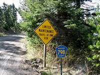
From I-84, 9 miles east from Arlington, take exit 147 and go via Oregon Highway 74 to Heppner, a distance of 45 miles, passing through the little towns of Ione and Lexington along the way. From Heppner, go south as the road leaves town but watch for road 678, Willow Creek Road and part of the Blue Mountain Byway which takes off to the left (east). Drive 21 miles to Morrow County road 798 (may be marked as FS 5326 on older maps) and turn left. You need to watch carefully for this road as it was partially hidden by a "low maintainance" sign. A road just before it is signed as the Black Mountain road but this is not the road you take. Topozone shows this road junction HERE.
Drive up 798 a couple miles to another junction which may be signed as FS 030, shown by Topozone to be HERE
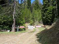
Turn left (north) onto this FS road and after driving up a short distance, you will encounter a gate, park here. Room for about two or three vehicles.
BTW, if you pass Cutsforth Park (a Morrow County Campground) then you have gone too far and will need to turn around and retrace your route until you find road 798.
This www.cohp trip report details another way to get to Black Mountain.
Red Tape
There is no red tape that I am aware of but should you find the gate open, I would be cautious about driving in with your vehicle as the gate could be gated and locked behind you.For more information:
Umatilla National Forest
2517 S.W. Hailey Avenue
Pendleton, OR 97801
541-278-3716
Heppner
Ranger District
P.O. Box 7
Heppner, OR 97836(541) 676-9187
Heppner Ranger District
The Heppner Ranger District is located in Heppner, Oregon. The District embraces 212,213 acres of the beautiful Blue Mountains, which includes portions of Grant, Morrow, Umatilla, and Wheeler Counties. There are approximately 500 miles of open roads to travel on, 27 miles of trails to hike, and 248 miles of streams that flow into 3 major rivers within Eastern Oregon.
Hunting, camping, and ATV/OHV riding are just some of the main attractions. The District also has Ditch Creek Guard Station and Tamarack Lookout Cabin available for rent. Bald Mountain Loop and Copple Butte Trail System are great for hiking or horseback riding, and they offer great views of the surrounding area.
The Blue Mountain Skyway road is a unique drive. MORE HERE
Camping
Want a totally different camping experience? Check out this opportunity:Tamarack Lookout Cabin
Forest Service Campgrounds HERE
Cutsforth County Campground HERE
Weather

Route to summit
More detail isn't really needed as you can follow a service road to the top from the gate.2 miles up
1000 feet elevation gain.
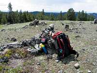
The highpoint is beyond the towers just to the northeast.
Morrow County Oregon
Thanks to Wikipedia for the following information:"The county was named for one of the first white settlers, Jackson L. Morrow, who was also member of the state legislature when the county was created. Half of the Umatilla Chemical Depot, which includes the Umatilla Chemical Agent Disposal Facility, is located within the county, northeast of the intersection of I-84 and I-82. The county seat is located at Heppner. As of 2000, the population is 10,996.
History
Morrow County Court House c. 1903
Morrow County was created on February 15, 1884 from the western portion of Umatilla County and a small portion of eastern Wasco County. Heppner was designated the temporary county seat at the time the county was created and narrowly defeated Lexington in the election held in 1887 to determine the permanent county seat.
Economy
The principal industries in the county today include agriculture, food processing, lumber, livestock, and recreation. The Columbia River also provides Morrow County with a number of related jobs. A coal-fired generating plant in Boardman also employs a significant number of people.
Early cattlemen found an abundance of rye along the creek bottoms of the region and drove their herds into the area to forage on these natural pastures. Ranching was the primary economic force in the county for many years. Increased settlement, the enclosure of the free grazing lands and diminished pastures due to overgrazing, resulted in the decline of ranching during the 19th century, and farming became predominant. The completion of rail lines into the county in 1883 increased access to markets and encouraged wheat production in the area. The advent of technology for center pivot irrigation has been a further stimulus to the local economy.
The Morrow Port District, situated on the Columbia River near the town of Boardman, was established in 1957.
The coal-fired electricity generation plant, the Boardman Turbine Coal Plant (601 megawatts), is located 14-miles southwest of the town of Boardman, and is owned by Portland General Electric (PGE; 66%-owned and operated), Idaho Power (10%), Pacific Northwest Generating (10%), and General Electric Credit Corp. (16%). There are also two natural gas-fired plants located at the Port of Morrow; Coyote Springs I (255-276 mW), owned and operated by Portland General Electric; and Coyote Springs II (241-280 mW; PGE operator), a fifty-fifty joint venture of Avista Power & Mirant Corp."
From S.P. Member Dundeel, we have this additional bit of history :
Heppner Flood
On June 14, 1903, a flash flood swept through the town of Heppner and destroyed most of it. Estimates of the dead ranged from 225 to more than 300. Relief trains were sent from Portland with food and supplies for the survivors. A story board and memorial can be found alongside the road on the north side of the town.


