
|
|
Mountain/Rock |
|---|---|
|
|
44.68400°N / 121.7994°W |
|
|
Marion |
|
|
Hiking, Mountaineering |
|
|
Summer, Fall |
|
|
9000 ft / 2743 m |
|
|
 Marion COHP
 Overview
One of the toughest county highpoints in Oregon is found on the side of Mt. Jefferson. The surveyors placed the dividing line between Marion and Linn County on a rocky ridge on Mt. Jefferson's north side and so you have your work cut out for you if you want to do this one. It is called a "liner" since the high point isn't on a summit but rather on the shoulder or side of a higher mountain that is in the adjacent county. Liners are a negative aspect of county highpointing in most cases but this one is more than just negative, it can be dangerous. It is considered by many that the actual summit of Mt. Jefferson may well be the toughest climb in the state (although North Sister may be the most dangerous) and so it is somewhat fitting that to get the highest point in Marion County, you have the toughest "liner" in the state and one of the toughest in the country. It is comparable to the one for Skamania county in Washington state that is found on the west side of Mt. Adams. Still, in order to complete all the county highpoints in the state of Oregon, it is necessary to go and find this "liner".
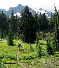
Now for the good stuff. The area known as Jefferson Park is one of the most scenic and delightful areas to be found in the Oregon Cascades. A parkland consisting of lakes, floral displays and snow capped peaks is a destination that is adequate for the majority of people. Plenty of camping spots and places to enjoy. The trail one needs to trod for the "liner" goes through some of this area before you have to leave and head higher up to the loftier altitudes beckoning on Mt. Jefferson's north side.
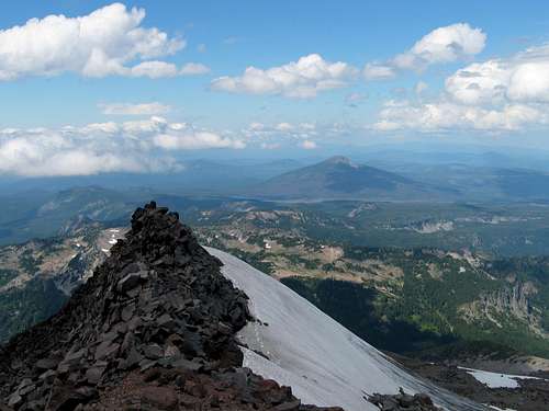
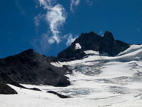
 The hp is on the left skyline on this fine pic by crevasse king.
Getting There
From Portland, head down I-5 to Salem and take the exit (exit 253) for Detroit, highway 22. Detroit is a place where you can find some groceries and gas and some cafes. From Detroit head east on SR 22 for 10 miles. Between mileposts 60 and 61, turn left on Whitewater Road 2243. This is a well graded road and except for some potholes you'll need to dodge on occasion, follow the road to its end about 7 miles later to the trailhead. A forest service pass is required to park there. NWForest pass are 30 bucks and are good for a year. Cars without them will be ticketed as rangers make frequent visits to the TH.The hike from the TH to Jefferson Park is roughly about 5 miles and gains 1800 feet. See route section for more information on the trail.
Quick note: We dayhiked it and estimated we covered close to 15 miles and had an elevation gain of 5500+ from the TH. Another SP member felt it was 13.5 miles and 5500 feet and took him 11 hours. It probably took us twelve (not including a stop for lunch and chatting with two other climbers, one of which was SP member artg.
Artg had this to say:
Route Climbed: North Ridge Date Climbed: August 9, 2003
Set up camp at Scout Lake and headed for the summit at noon. Started on the rocks of Whitewater Ridge and around 8,000 ft. we moved onto the Whitewater Glacier because the rocks were starting to hamper our progress. On the way to the summit pinnacle, we ran into Dean and rfbolton (nice lads), summit post members who were busy with their county high points climb.
Reached the base of the summit pinnacle (approximately 9,500 ft) at 5 PM and aborted a summit attempt for several reasons: 1) on the way to the summit pinnacle we encountered loose rock fall that went from bad to ridiculous. Pebbles, sand, rocks, scree-you name it, it was coming down with every step taken and the pinnacle itself didn't look any better (found someone's prusik sling in the jumbled mess); 2) throughout the day, clouds buried the summit pinnacle which would make routefinding arduous; 3) started the climb late in the day. Will try another attempt from the south or southwest ridges sometime in 2004.
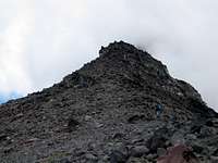 Bob closing on highpoint
Go to highest magnification to get the feel for what lies above us.
Red Tape
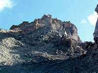 Artg's shot of the north ridge from the east
As noted above, a forest service pass is necessary for parking at the trailhead. For more information on this pass, click here
Detroit Ranger District
HC73, Box 320
Mill City, OR 97360
503-854-3366
FAX 503-854-4239
Summer hours: 7 days a week 8-4:30 Memorial Day - Labor Day
September hours: Monday-Saturday 8-4:30 Closed Sundays
Regular hours: Monday-Friday 8-4:30
 The Jefferson Park Glacier
Camping
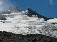
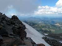 Looking north from the north ridge...8500 foot level
Although this can be done as a dayhike, it probably makes more sense to camp over night. Jefferson Park is a special place and has many campsites that will serve well for the backpacking experience.
Campgrounds in the area
Dispersed Camping
Jefferson Park
For a map and information click here
More information will be provided about the trail in the route section and Jefferson Park
Trip reports from COHP.org
Read the following two reports for a bit more awareness of the nature of this liner:Trip report one
Trip report two
Bob Bolton and I have a short trip report posted there as well
Our report
Marion County itself
MARION COUNTYHere's some information about the county (thanks to Wikipedia)
The county was originally named the Champooick District, after Champoeg, a meeting place on the Willamette River. On September 3, 1849, the territorial legislature renamed the county for Francis Marion, a general in the American Revolutionary War. As of 2005, the population is 305,265. The county seat is Salem.
History
Marion county was created in July 5, 1843, one of the original four districts of the Oregon territory along with Twality (later Washington), Clackamas, and Yamhill counties. The four districts were redesignated as counties in 1845.
Originally, this political entity stretched southward to the California border and eastward to the Rocky Mountains. With the creation of Wasco, Linn, Polk, and other counties, its area was reduced in size. Marion County's present geographical boundaries were established in 1856.
In 1849 Salem was designated the county seat. The territorial capital was moved from Oregon City to Salem in 1852. The ensuing controversy over the location of the capital was settled in 1864 when Salem was confirmed as the state capital.
Economy
Agriculture and food processing are important to the county's economy, as are lumber, manufacturing, and education. Marion county has 10,640 acres (43 km²) planted in orchards. Government, however, is the county's main employer and economic base.
Weather
Detroit Oregon is a good indicator for the kind of weather you will encounter