
|
|
Mountain/Rock |
|---|---|
|
|
44.50407°N / 123.55182°W |
|
|
Benton (County High Point) |
|
|
Hiking |
|
|
Spring, Summer, Fall, Winter |
|
|
4097 ft / 1249 m |
|
|
Benton County Highpoint
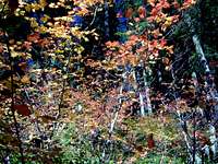
The county highpoint for Benton County, Marys Peak is the highest point in the Oregon Coast Range and offers a nice panoramic view of the coast to the west and of the Willamette Valley and Cascade Range to the east. On a clear day it is possible to see the summit pinnacle of Mt Thielsen to the southeast; while Mt Adams is visible to the north with Rainier barely distinguishable using binoculars. This peak also offers a nighttime view, with all the major cities of the Willamette Valley visible to varying degrees and several coastal communities noticeable to the west. Marys Peak is home to several different clusters of transmitters and radio towers, including two buildings at the summit.
Unlike other peaks in the coast range; Marys Peak has an alpine clearing at the top that offers skiing activities in the winter, and camping and sightseeing activities during other seasons. This grassy opening offers a pleasant area to frolick any time of the year, and its common to see people either enjoying a quiet picnic in the grass or children playing games.
Geologically Marys Peak is a basaltic uplift like much of the coast range caused by the subduction of the Juan de Fuca plate beneath Oregon. As the JdF continues its eastward march, the North American Plate is lifted upwards along its western edge forming the coast range.
Marys Peak is #11 on the list of Oregon peaks with 2000 feet or more of prominence.
Getting There
From Interstate 5 take the highway 34 exit to Corvallis. Follow highway 34 through Corvallis to Philomath then travel 10 miles west on highway 34 to Marys Peak road on the north side of the highway. Note that highway 34 splits to the left on the west side of Philomath, do not continue straight towards Newport on highway 20. Follow Marys Peak Road 5.5 miles to the East Ridge Trailhead parking area. Typically Marys Peak Road is gated at the East Ridge Trailhead from December 1st until March 31st.
The standard route is the East Ridge Trail, a mild 2.5 mile path that begins in spruce and Douglas Fir trees switchbacking up the east face until entering a band of Noble Fir around the grassy summit. The east ridge trail has roughly 1700 feet of elevation gain.
The slightly longer North Ridge Trail begins on Woods Creek Road which is 2 miles west of Philomath on the south side of the Highway 20. Travel roughly 8 miles up Woods Creek Road to the North Ridge Trailhead. The north ridge trail has roughly 2200 feet of elevation gain although this needs clarification.
The Siuslaw National Forest website maintains several maps of the trails on Marys Peak.
Red Tape
The Northwest Forest Pass is required for parking and campsites. As stated the road is closed at the East Ridge Trailhead Conner's Camp parking area during winter, and any time when snow renders the road impassable. Marys Peak is a sensitive botanical area, and at the head of Corvallis Watershed; tread lightly.
When to Climb
Anytime of year providing the road is plowed.
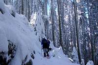
For Winter hiking; Marys Peak Road maybe plowed to the Conner's Camp / East Ridge Trailhead parking lot during winter months. If interested in making the trip to the summit, the East Ridge Trail is well marked with blue diamond shaped trailmarkers and if closed the road could be easily walked to the summit.
In event of plentiful snowfall, Marys Peak offers easy access to a mid-valley peak with potential for skiing and sledding if your looking for somewhere to take the kids for the afternoon.
Camping
Camping is available at Marys Peak Campground at the roads end. 6 sites are available from April to September on a first come first serve basis. More information can be found on the Siuslaw National Forest website