
|
|
Mountain/Rock |
|---|---|
|
|
38.95586°N / 106.43674°W |
|
|
Hiking, Mountaineering, Scrambling |
|
|
Spring, Summer, Fall, Winter |
|
|
13523 ft / 4122 m |
|
|
Overview


Browns Peak is located in the heart of the Sawatch Range and is thirteen miles from the closest paved road. Its presence dominates Lulu Gulch, but sits in the shadow of Huron Peak. Due to the popularity of its neighbor, Browns Peak sees few summits. On a clear day from the summit of Browns you can see all fifteen of the Sawatch fourteeners. The separation between Huron and Browns is .75 mile and offers a fun traverse to the spectacular summit of Huron.
Climbing Overview
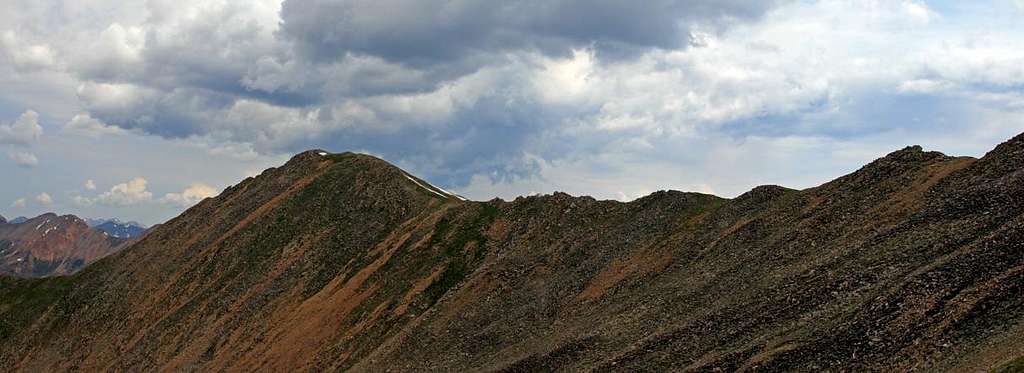
Browns Peak provides a wonderful day hike in the heart of the Sawatch Range. From Lulu Gulch you can climb along an old mining ‘road’ as it switchbacks up the side of Middle Mountain (13,060). As the ‘road’ tops out on Middle Mountain’s summit ridge, traverse (class 2) into the basin formed by Middle Mountain and Browns Peak.
This basin is filled with tons of wildflowers. Hike toward Browns saddle with Point 13,462. Once gaining the saddle you have spectacular views of Huron. Climb to the summit of Browns (easy class 2).
If weather permits, stay high on the ridge that connects Browns and Huron. Talus hop on delightfully solid rock along the ridge until you connect with the Huron trail. There is no trail or old mining road here so it's all up to you. The 'crux' of the traverse is descending to the ridge from Brown's summit (moderate class 2).
Getting There
 If coming from Buena Vista: Drive 14.5 miles north on U.S. 24 and turn left on the Chaffee County 390 road. On the 390 road (dirt), drive 11.3 miles to Winfield. From Winfield turn Left and travel .2 mile to the beginning of a 4wd road, passenger cars should park here. 4wd cars with good clearance can continue for about another 2 miles (from Winfield) into Lulu Gulch. After about .3 mile from the start of the 4wd road there is a junction(marked only by a small camping sign); turn right for the Huron Trailhead, turn left for Browns Peak. Continue for another 1.5 mile to another junction, turn left and ascend into Lulu Gulch. Pull-offs are available for parking.
NOTES: After the Huron/Brown junction, the road to Lulu Gulch is a 4wd road in every sense of the word! Be Careful! If you plan on climbing both Browns and Huron, park in a pull-off near the Huron/Browns junction and ascend the road on foot.
Red Tape

![]() Browns Peak is located in the San Isabel National Forest and Leadville Ranger District. No permits or fees are required to climb or camp.
Browns Peak is located in the San Isabel National Forest and Leadville Ranger District. No permits or fees are required to climb or camp.
Leadville Ranger District
San Isabel National Forest
2013 N. Poplar
Leadville, CO 80461
Phone: (719) 486-0749
Fax: (719) 486-0928.
Camping
There are some great primitive camp sites along the 4wd road to the Huron trailhead. Camping is also possible near the pull-offs in the Lulu gulch area.
The Camp sites near the Huron Trailhead have fire pits and provide great views of the most rugged peaks in the Sawatch Range: The Three Apostles.
Running water is available in both locations.
Weather
For current weather conditions please click the icon below:
External Links
Hiking Colorado-Browns and Huron
www.14ers.com-The Home of Colorado's Fourteeners
gimpilator - Nov 29, 2015 12:32 pm - Hasn't voted
Coordinates GlitchI just stumbled onto a strange glitch which corrupted the location of numerous pages and listed them all at the same point in southern AZ, USA. Please fix the coordinates of this page to the following (38.955864, -106.436738), and I'll be happy to remove my "needs updates" vote. Thanks!
swm88er - Dec 9, 2015 1:55 pm - Hasn't voted
Re: Coordinates GlitchThanks for the update! Should be corrected now...Not sure how that happened. Cheers