Overview
Furkotský štít (svk) -
Furkot (pl) -
Rauschbachspitze (Furkotaspitze) (ger) -
Furkota-csúcs (hun)
This album will be deleted as soon as I complete the page about the mountain
Furkotský štít (2405 m) in the
High Tatras range in Slovakia in central Europe. If you´ve got any photo related to that mountain, feel free to add it here. I will add them to the mountain page, too. Building of the page will long a couple of weeks.
Origin of the name
Furkotský štít is the very culmination of the valley Furkotská dolina. However, there is one higher peak above this valley -
Veľké Solisko (2414 m) in the Solisko ridge. These two has one common root of word: furkotsk- (furkoc). This slovak word does mean "to lollop", "to pronk", "to jump". The name is of the folk literature from past centuries. By this word it is meant, that the creek is lolloping, jumping slowly while flowing down the valley. The creek has the name Furkotský potok, too. However, the true is that the valley lacks major waterfalls.
Location
Furkotská dolina is one of shorter south oriented valleys in the
High Tatras national park. And when speaking about water, there is one interesting thing about water here.
Furkotský štít itself, as well as the ridge of Solisko
is the part of the main european water divide: valley to the east of it (Mlynická dolina) collects water through Mlynický potok to the river Poprad and further to the Northern sea, while Furkotská dolina collects water which finally flows into the Black sea. Furkotský štít is looming also above the third valley named Nefcerka. Nefcerka supports the Black sea with its waters. There are two higher peaks above the valley:
Hrubý vrch (2428 m) and
Kriváň (2495 m). Beyond Veľké Solisko and Hrubý vrch there is third peak higher than Furkotský štít above Mlynická valley -
Satan (2432 m).
Why is Furkotský štít attractive and for whom?
While Furkotský štít is not the highest in the neighbourhood, it is important because of its location above three valleys. It is neither attractive for climbers, the toughest route to it is of grade II UIAA (from valley Nefcerka). What is perfect about Furkotský štít is the view from the top. It's been visited by queues of hikers because it is easily accessible. Its slopes and especially the one into the Furkotská valley is often skialpinist terrain right down from the summit. Furkotský štít and its neighbourhood is also in the centre of the attention of nature conservers and scientists. The slope from Mlynická include one chute highly exposed to erosion, because it is made of mylonite geological unit lying among granite blocks that are less exposed to erosion. Problems here are - orientation of uncaring hikers that go away from trail marks an follow the chute for their ascent. The other problem is connected with this one: damaging of scarce mountain flora. You can see, the peak is a scarce resource and there are different visions of the use of the peak and it is usual that the use of scarce resources is a very attractive object of legislative regulations. You can believe me, in this light it is very attractive summit.
First ascend
Its first known ascenders were K. Tetmajer and T. Żeleński, with Polish guides in summer sometime between 1889-1893. Earlier chamois hunters, before 1880 guides from Zakopane and military mappers have been on the peak.
First winter ascenders were Emil Baur, Alfred Martin and Hans Schäfer on 4th january 1906 from the saddle Bystré sedlo.
Red tape
This section was written in controversial style and reality could be quite different from what was written here. For red tape in Tatras national park, see the page of
Vysoké Tatry. Date of correction: 30th january 2009
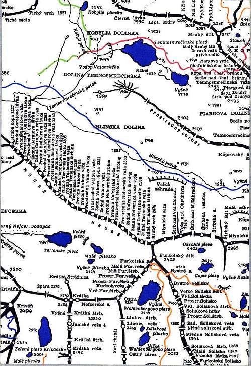
Maps
Look for the maps listed in maps section of the High Tatras range page. Two specific maps are shown here, one of which include current direction of marked hiking trail directly to Bystré saddle (2334 m) and the other one, with names of all towers and saddles, include old marked trail through Furkotské sedlo and Bystrý priechod (2370 m) just dozens of meters away from the summit. Trail was redirected due to nature conservation and better keeping of law. Formerly many people went to Furkotský štít from Bystrý priechod, despite it was forbidden. Summit was easily accessible from there and part of the trail led through erosion-exposed chute, what led to accidents (I'm wittness of one accident which ended with broken arm and helicopter rescue) and damaging of scarce flora.
![]() |
![]() |
| Map with the new, redirected trail. |
Perfect climbing map with old direction of the trail. |
External links
Some photo albums:
A summer trip
360 degrees wonderful autumn panorama from the summit
Skialpinism above Mlynická valley


Comments
Post a Comment