
-
 19670 Hits
-
 86.37% Score
-
 22 Votes
|
|
Mountain/Rock |
|---|---|
|
|
44.11280°N / 115.0969°W |
|
|
Hiking, Mountaineering, Trad Climbing |
|
|
Spring, Summer, Fall |
|
|
9144 ft / 2787 m |
|
|
Overview
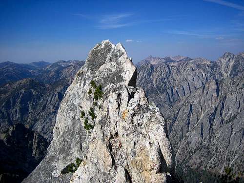
Grandjean Peak could be the most complex peak in the Sawtooth Range. It's summit ridge is comprised of 5 separate towers, of which several require Class 5 climbing. The peak sits on the same Monte Verita ridgeline as Warbonnet Peak and Tohobit Peak. Despite being one of the closer peaks to a trailhead (just 3.7 miles), it's summit sees few visits due to it's intimidating north side (with difficult creek crossing) and trail-less southern approaches via Goat Creek. In fact, between 1973 and 1996 there were only 13 recorded visits according to the summit log.Grandjean Peak is named after Emil Grandjean, a Danish forester and the first Sawtooth Forest supervisor in 1905. He mined, trapped and explored the Salmon River area of central Idaho in the late 1800's before becoming the supervisor of the Payette National Forest and then the Sawtooth National Forest. More recently, Bob and Sheila Dargatz placed the original summit register and Greg Parker has explored and developed this region extensively. Many of the routes along this whole ridgeline have been pioneered by Greg Parker. The peak has also claimed at least one life and another serious accident on it's exposed, steep, and often loose slopes.
- Southwest Ridge (Class 3)- Difficult and challenging scramble. Hike the South Fork of the Payette River Trail. Hike up to the point where Goat Creek flows out of it's canyon. Take this trail-less canyon, hiking over numerous fallen trees and difficult brush for 1.1 miles. From here ascend the steep and loose southwest gully that runs up to the saddle between Point 9105 and the next Grandjean summit to the southeast. The nature of this gully is very much like the south side gulleys on Mt. Heyburn, only steeper and more loose! From the saddle the scrambling is a bit more firm, but more exposed as you ascend to the northwest onto 9105. Note: If you continue up the trail-less, but spectacular Goat Creek you'll come to the Bead Lake area where most of the Warbonnet climbers have their camps.
Total Mileage / Elevation Gain (One-Way): 5.2 miles / 4221 feet
- North Slope / West Ridge (Class 3)- Probably the easiest way up a Grandjean summit. Described in the Routes section.
>Peak 9144 (Easternmost Summit)- The highest pinnacle and point on Grandjean Peak.
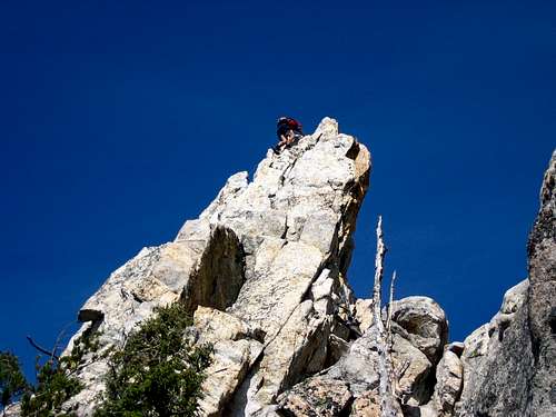
- East Face (II 5.6)- Lots of route finding and scrambling will take you to the base of Grandjean Peak's highest point. At the base you'll have great views (directly behind you) of Tohobit Peak, Baron Spire and Mayan Temple. From the base, locate an obvious slot. Directly above the slot is a short, wide chimney. Make an awkward move from the slot into the chimney using a finger layback that leads to a few face moves. The initial move is the hardest, and is protected by nuts or a .5 to #1 cam. To rappel off the summit, utilize a block that has a chockstone slotted into the back to keep your sling from riding up.
Total Mileage / Elevation Gain (One-Way): 5.6 miles / 4607 feet
- Summit Ridge Traverse (Class 4-5)- The ultimate of Grandjean tours will require some exposed climbing, down climbing, and short rappels. This traverse was reported as done from 9105 to 9144 by Greg Parker.
Total Mileage / Elevation Gain (One-Way): 5.1 miles / 5205 feet
Equipment: A full rack of nuts, cams, and runners is recommended for all routes above Class 3. A helmet is a must given the variable and steep nature of the terrain. You may want a GPS as a back-up because it can be difficult to tell which of the summits your climbing up to (especially on the south side) when your in the gulleys.
Maps: USGS Warbonnet Peak Quad Note: The quad inaccurately depicts vegetation / forest due to wildfires on these slopes in the 1990s
 |  |  |  |  |
Getting There
Road ApproachOn ID-21, continue northeast past Lowman for 25 miles. Turn Right at sign for Sawtooth Lodge and continue for 6 miles on very good dirt road. At Grandjean, take left fork to the hiker's/horse trailhead and campground area. Park at the Backpackers / Hikers trailhead.
Hike / Scramble Approach
North Side:
From the trailhead hike South along the Grandjean trail for 1 1/2 miles until it reaches the South Fork of the Payette River. Take the Baron Creek fork to the East (left) and continue up the trail for approximately 1 mile for the 9105 scramble. Look for the avalanched hillside with a path coming down from up and to the left (east). Cross Baron Creek where you can- can be very difficult in high water. For the 9144 climb, continue 3 miles past the first junction near the South Fork Payette / Baron Creek Trail split.
South Side:
From the trailhead hike South along the Grandjean trail for 1 1/2 miles until it reaches the South Fork of the Payette River. Cross the South Fork of the Payette River (this may be impassable during spring runoff) and continue along the trail toward Elk Lake for approximately 1 mile. Leave the trail and head East at the first major drainage system (Goat Creek) and continue cross country up the creek drainage for 1.1 miles.
 |  |  |  |
When To Climb
Standard climbing season is June through October. Conditions vary greatly. Grandjean is about 1000 feet lower in elevation than Stanley so it can be hotter in the summer, but just as snowy and stormy most of the time. Nearby Stanley, Idaho Climate Data:| Jan | Feb | Mar | Apr | May | Jun | Jul | Aug | Sep | Oct | Nov | Dec | Annual | |
| Average Max. Temperature (F) | 27.0 | 33.7 | 42.5 | 50.3 | 59.9 | 68.4 | 78.7 | 78.4 | 68.6 | 56.6 | 38.1 | 26.0 | 52.4 |
| Average Min. Temperature (F) | -0.5 | 0.3 | 9.7 | 20.3 | 28.3 | 33.9 | 36.0 | 34.0 | 27.2 | 20.6 | 12.0 | -0.8 | 18.4 |
| Average Total Precipitation (in.) | 1.64 | 1.33 | 1.02 | 1.02 | 1.17 | 1.16 | 0.59 | 0.59 | 0.78 | 0.92 | 1.46 | 1.55 | 13.24 |
| Average Total SnowFall (in.) | 16.9 | 13.2 | 10.2 | 3.4 | 0.9 | 0.2 | 0.0 | 0.0 | 0.4 | 1.7 | 10.4 | 14.6 | 71.9 |
| Average Snow Depth (in.) | 18 | 20 | 15 | 6 | 0 | 0 | 0 | 0 | 0 | 0 | 2 | 8 | 6 |
The Grandjean Road is typically not plowed from ID-21 in to the trailhead
Mountain Conditions
Latest Avalanche Report (Sawtooth Area)
http://www.avalanche.org/~svavctr/
National Weather Service Current Forecast for Stanley:
http://newweb.wrh.noaa.gov/total_forecast/index.php?wfo=pih&zone=idz018&fire=idz406&county=idc037
Sawtooth Web Cam can give you a good idea of the conditions in the area:
http://www.ruralnetwork.net/~dpinney/
Sawtooth National Recreation Area
http://www.fs.fed.us/r4/sawtooth/recreation/recreport.htm
SNOTEL site gives latest snow depth readings:
http://www.wcc.nrcs.usda.gov/snotel/snotel.pl?sitenum=845&state=id
Camping
- Sawtooth Lodge near the trailhead offers rustic cabins with a small store
- Grandjean Campground offers first come drive-in sites
- Good bivy spots could be found along Baron Creek or the South Fork of the Payette (Once you enter the Sawtooth Wilderness Area)
Climbing Information / Sources
Sawtooth Climbing Beta is hard to come by. Grandjean Peak information is even harder to come by. An internet search returns virtually nothing. There is no official book or publication that gives detailed description. Here are a few references that have some more basic information and photographs on nearby climbs:1) Climbing Magazine #15
2) Rock & Ice #44
3) Off Belay: The Mountain Magazine Feb 1975 #19 (Whole issue devoted to rock climbing in the Sawtooths, but hard to find)
4) American Alpine Journal- Issue 47 (1973)