
|
|
Mountain/Rock |
|---|---|
|
|
50.58517°N / 115.00457°W |
|
|
Hiking, Scrambling |
|
|
Summer, Fall |
|
|
9090 ft / 2771 m |
|
|
Overview
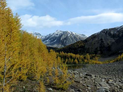
This is one of the pyramid-shaped peaks with folded rock layers that you see as you approach Highwood Pass from the north. There are two mountains unofficially named Grizzly Peak in Kananaskis Country. This is the higher of the two at 2770 m/9090 ft, and while not particularly prominent or visible because it is sandwiched between higher peaks, it is a popular class 2 hike/scramble from Highwood Pass. The approach passes through one of the finest alpine cirques (full of larches!) in the Canadian Rockies, and due to the high start is not a lot of effort to climb.
Getting There
From Calgary, drive west on Highway #1 (the Trans-Canada) until the Highway #40 (Kananaskis Trail) intersection. Drive south on #40 past Nakiska ski resort and the Kananaskis Lakes turnoff, at which point the highway turns a sharp left into the valley of Pocaterra Creek and climbs steadily toward Highwood Pass. At the summit of the pass (the highest paved road in Canada at 2206 metres/7237 feet) park in the large, paved Highwood Pass parking lot on the right, just below treeline.
Highwood Pass can also be accessed from the south by driving west on Highway #541 and then north on Highway #40 from the village of Longview. Both are excellent paved roads.
Route
This is the standard route up the west ridge, but there are a couple of other routes, one a moderate scramble up the east ridge and the other a longer trek up the length of Grizzly Ridge from Mount Lipsett day-use area.
Leave the north end of the parking lot on the gravelled Highwood Meadows interpretive trail. Shortly turn left on an unnofficial dirt trail which follows an open draw for a minute and then turns left into lush subalpine fir forest. Unfortunately the next stretch of trail climbing up and over the north end of Highwood Ridge is very muddy due to high use, high moisture and lack of maintenance, so please try to not trample additional vegetation! En route, ignore two side trails turning left (they lead up Highwood Ridge).
In a minute the trail traverses left out of the fir forest onto an open avalanche slope covered in cow parsnip and forgetmenots with a view of Pocaterra Cirque ahead. The big grassy ridge on the right is Pocaterra Ridge (2667 m/8750 ft) and the peak behind it is Mount Pocaterra (listed as 2941 m/9648 ft). The trail then turns right, enters the fabulous alpine larch forest, and descends to the infant Pocaterra Creek. Then it climbs up an open slope at the edge of the larch forest below the north face of Grizzly Peak and turns right, through the larches, into a long open meadow with a view of Pocaterra Ridge ahead. Come to a cairned junction and turn left up the hill (ahead leads to Pocaterra Ridge) on the less-used trail.
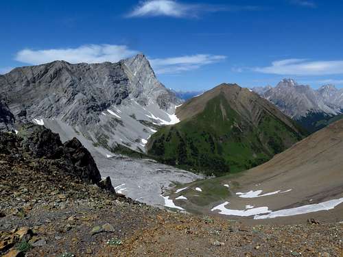
Your new trail climbs steeply over the crest of a hill out of the larches to the base of a large moraine. Still fairly distinct, it climbs up the scree of the moraine, angling left into the treeless upper cirque between Grizzly Peak and Mount Tyrwhitt. Soon it reaches a flat meadow with an excellent view back to Mount Pocaterra and Pocaterra Ridge, and of Grizzly Col slung between Mount Tyrwhitt and Grizzly Peak ahead (with your trail snaking up to it).
The trail then turns left and zigs up orange scree on the east face of Grizzly Peak, then begins a long, rising traverse (tongues of snow until midsummer) across scree to a rock rib. Scramble over the rock rib and up the last bit of steep scree to Grizzly Col (2606 m/8550 ft). The other side of the col is a gentle scree slope leading into the valley of upper Storm Creek.
Turn left on a fainter trail up the east ridge. It soon traverses out to the right on a flowery slope, then climbs up a steep slope of black-lichened boulders. Reach the top of crest of what is called Grizzly Ridge (amazing wildflowers) at about 2700 metres and turn left.
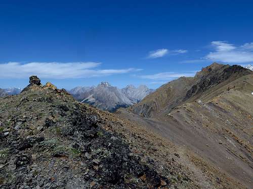
The gentle grassy ridge soon ends and turns into a narrow ridge of sandstone, which requires some slightly awkward traverses on the right side of the ridge. After an easy stretch, the ridge turns back to black lichen-covered rock again you scramble over a fin of black-lichened rock and scramble up a mildly exposed ramp on the right side of the ridge to the summit.
While sandwiched between higher peaks, the summit has a really neat view of Paradise Valley to the south and its incredible neon-green grass. And you might just find a skycress flower growing right on top beside the cairn...
Red Tape
Grizzly Peak lies within Peter Lougheed Provincial Park, which is part of the multi-use Kananaskis Country. Due to high use no random camping is permitted within Peter Lougheed Provincial Park (although this is not generally true of Kananaskis Country). Also, no drones are permitted. There are no other special regulations that affect non-motorized users
When to Climb
Highway #40 is closed between December 1 and June 15 between Kananaskis Lakes Road and Highwood Junction for wildlife management reasons, so this area is innaccessible between those dates. This peak is generally in condition between June and late September when snow comes at high elevations. I do not know of anyone who has climbed this peak in the winter.
Camping
No random camping is permitted in Peter Lougheed Provincial Park, although this peak is close to the road so this shouldn't be a problem. There are quite a few front-country campgrounds at Kananaskis Lakes, about 15-20 minutes drive to the north.
Precautions
Highwood Pass is a major grizzly bear hotspot, so take all necessary precautions.
External Links
Kananaskis Country, Alberta Parks: https://www.albertaparks.ca/parks/kananaskis/kananaskis-country/
Peter Lougheed Provincial Park information and facilities: https://www.albertaparks.ca/parks/kananaskis/peter-lougheed-pp/information-facilities/