
-
 11675 Hits
-
 84.27% Score
-
 18 Votes
|
|
Mountain/Rock |
|---|---|
|
|
47.01163°N / 11.61633°E |
|
|
Hiking, Scrambling, Via Ferrata, Skiing |
|
|
9839 ft / 2999 m |
|
|
Overview
 Kraxentrager / La Gerla Kraxentrager / La Gerla |
What does it feel like to be a mountain just 1m short of 3000m? If mountains can feel - which I find doubtful - Kraxentrager (La Gerla in Italian) must be permanently annoyed. At 2999m just 1m is missing and the only consolation can be that the top of the summit cross easily is at more than 3000m. Still the mountain, which you can find in the middle of the Tux Main Ridge of the Zillertal Alps, is a popular hiking destination. Popular that is for this area of the Alps which is best known as a backdrop for the voyage across the Brenner Pass which lies at its feet.
Millions of people each year travel that road and most could see Kraxentrager while crossing the border between Austria and Italy but I guess most are in no way aware of it. Still the mountain is often climbed, either from Brenner Pass or from the saddle of Pfitscher Joch / Passo di Fizze deep in the Zillertal Alps. Both routes are very strenuous - from Brenner Pass it is an elevation gain of 1600m, from Pfitscher Joch only 1200m but with additional 10km in distance. Therefore it comes handy, that underneath its western neighbour, Friedrichshöhe (2713m), you find a hut, Landshuter Europahütte / Rifugio Venna alla Gerla. It is located on the border between Austria and Italy (like Kraxentrager itself) and serves the Tiroler Höhenweg, a trekking trail which traverses all parts of Tyrol. In conjuncting with trekking along this trail, Kraxentrager is most oftenn climbed.
Depending on the direction from which you look at the mountain, it sometimes vanishes beneath its eastern neighbour, Hohe Wand / Croda Alta (3289m). Still it has a unique summit, slightly overhanging on its eastern side. It is made up from Granite slabs and blocks, typical for the higher part of Tux Main Ridge, but quite unique if you look at the further surroundings which are often made up from micaceous schist. From the hut it takes about 1h to reach the summit, a path which has been "paved" with large granite slabs and which has a short section, secured by a fixed steel cable. Apart from this short section, which would be graded UIAA I without the cable, the climb is rather straightforward.
Thanks to its position on the high Tux Main Ridge Kraxentrager is a good lookout summit. Only the view to the east is blocked by the higher Hohe Wand / Croda Alta, all other directions are free. Especially the looks towards Hochfeiler / Gran Pilastro and the Pfunderer Berge / Monti di Fundres are impressive. During our own climb, which we started from Pfitscher Joch, the summit shrouded itself in clouds as we approached around noon so that many of the "summit shots were taken during the ascent, not on the summit itself.
|


Views
HochstellerRotbachlspitzeGroßer MöselerRötwandHochfernerWeißspitzenFituidenkopfNiederer WeißzintBlauer KofelÖstl. HochwartWestl. HochwartRöteckEngbergPletzenspitzeRotes BeilVord. LangspitzeHint. LangspitzeHochsägeFelbeWurmaulspitzeGrabspitzeZwölferspitzeBlickenspitzeWilde KreuzspitzeRübespitzeEbengrubenspitzeKramerspitzeFackenzähneTorwandGroßberspitzeÜberseilspitzeS a r n t a l A l p s 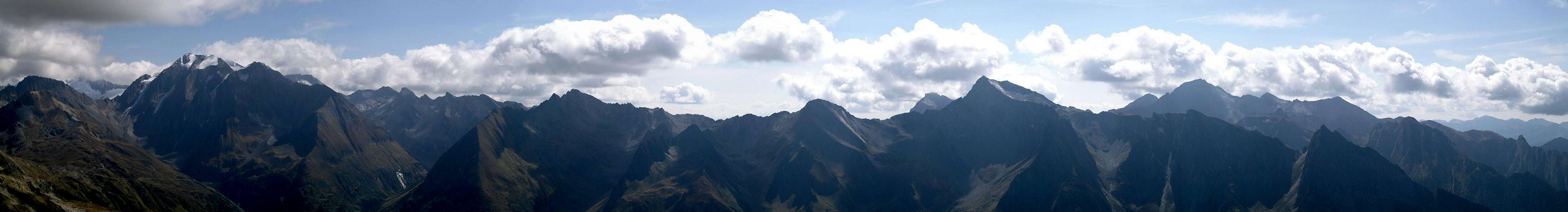  |
I can't call this section "summit views" as only few of these shots have actually been taken from the Kraxentrager summit. However, the shots were taken within 200m (vertical) of the summit and give a good representation of what to expect. The mountains in the north and north-west were invisible all the time :-(
|


Getting There
 Pfitscher Tal / Val di Vizze
- Brenner Pass Trailhead
Nothing easier than this: Take the Brenner Motorway A22 and leave it at the exit Brenner. Park near the train stattion and start hiking up Venntal (trail 75).
- Pfitscher Joch / Passo di Vizze
Again, take Brenner Motorway but leave it 16km south of the border at Sterzing / Vipiteno. Take SS508 through Pfitscher Tal / Val di Vizze. The paved road ends at Stein, but you can go on on the dirt road up to an elevation of approx. 1760m. From there on the road is closed but there is a large parking lot to be found here. Either climmb to Tiroler Höhenweg directly (north-west) or climb to the saddle in the east. The latter route is longer but you can hike along the Tiroler Höhenweg Trekking trail (also called Landshuter Höhenweg), a beautiful highroad with good views.
- Pfitscher Tal / Valle di Vizze
You can also climb the mountain from Platz / Plazza or St. JJakob / S. Giacomo in Pfitscher Tal. The directions are the same as for the Pfitscher Joch Saddle. You have to stop at one of the villages named above and start your climb from there. However, the climb is steep and gains about 1600m in elevation.
Red Tape
 Wildseespitze (2733m)
There's no red tape here, however the Austrian - Italian border runs across the Tux Main Ridge startuing at Wolfendorn / Spina del Lupo and ending at Hohe Wand / Croda Alta. Kraxenträger is right in the centre of this stretch of the ridge so it might be a good idea to have an ID with you, even in these times of open European borders.
Accommodation
Hotels and Apartments
Though on Brenner Pass there are a number of hotels, I woould rather suggest staying a bit further north or south of the border. The restaurants and shops at Brenner are very expensive and I assume the same for the hotels.
Huts
The closest hut is