
-
 6562 Hits
-
 75% Score
-
 6 Votes
|
|
Mountain/Rock |
|---|---|
|
|
42.79439°N / 0.91659°E |
|
|
Download GPX » View Route on Map |
|
|
Mountaineering |
|
|
Spring, Summer, Fall |
|
|
9462 ft / 2884 m |
|
|
Overview
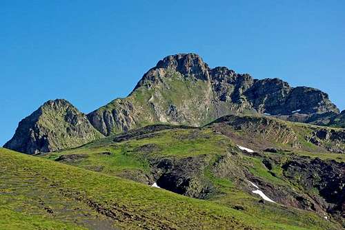
Tuc de Maubèrme
Tuc de Maubèrme (2,884m) is the highest and most important peak at North of valley of Aran in the border with France. It's a big and isolated peak very visible from a lot of places but it's not very frequented.
The most popular route goes from South side of the peak, with trailhead in Bagergue but you have another options from French side.
Routes:
-South: Baguerge (4h), 1,500m.
-North: Eylie (6h), 2,000m. This route is advisable in 2 days sleeping in the small free hut of Urets at 1,940m(10 places).
 |  |  |  |
Getting There

South route (Spain): trailhead in the village of Bagergue, at East of Vielha, taking the small road in Salardú.
See bigger map
North route (France): valley of Biros. From the village of Eylie.
See bigger map
Red Tape

Camping
-Campings:Prado Verde, at 12km of Vielha.
Bedurapark, at 8km of Vielha.
Verneda, near of Vielha.
Artigané, near of Vielha.
La Mola, Espot.
External Links
senderismo valle d'Aranmendikat.net, text in Spanish.
pirineos3000, text in Spanish.
paconudels-blog, text in Spanish.
ruteandopro, text in Spanish (North route).
wikiloc
visentin - Aug 7, 2012 5:03 pm - Voted 10/10
andof the Ariege !
Rafa Bartolome - Aug 7, 2012 5:38 pm - Hasn't voted
Re: andof course. I'm still working in the page. thanks