
-
 32482 Hits
-
 83.69% Score
-
 17 Votes
|
|
Mountain/Rock |
|---|---|
|
|
37.32601°N / 121.61994°W |
|
|
Santa Clara |
|
|
Hiking |
|
|
Spring, Summer, Fall, Winter |
|
|
4230 ft / 1289 m |
|
|
Overview
Mt. Isabel is a broad, brush covered peak 1 mile south of Mt. Hamilton and Copernicus Peak. It is easily viewed from San Jose as the dark, dome shaped mountain that looms to the right of Mt. Hamilton and the Lick Observatory. If viewed upon from San Jose, one might say that Mt. Hamilton appears taller than Mt. Isabel, but Mt. Isabel is actually 17 feet higher than the summit of Mt. Hamilton. This makes Mt. Isabel the second highest peak in Santa Clara County, after Copernicus Peak. An old, not-much traveled fireroad leads to the summit, which leads me to believe that this peak isn't hiked very much. The fact that the peak is on private property (although for not much longer! See 'Red Tape') also, I assume, hinders hikers from bagging it. A summit log existed from Feb. 2006 until Spring 2007, when it was replaced with a note from the land owner warning hikers that the minimum fine for trespassing on Mt. Isabel is $ 200. Wild boars also reside on the slopes of Mt. Isabel. The views are excellent from the top, stretching south through the Diablo Range, east to the Sierra Nevada (on a clear day), west into Silicon Valley, and north for a close-up of the Lick Observatory on Mt. Hamilton. Climber.org lists Mt. Isabel as an S10 on the Sneak Peak Climbing scale, yet this is way overrated. Mt. Isabel would be about an S4 on the scale.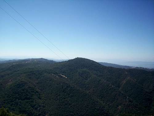
Mt. Isabel as viewed from the summit of Copernicus Peak
Getting There
The fireroad that leads to the summit of Mt. Isabel begins at the Smith Creek fire station on Mt. Hamilton Road. From I-680 in San Jose, exit Alum Rock Ave. and head east, towards the hills. After about 2 miles, you'll see Mt. Hamilton Road veer off to the right. Take Mt. Ham road for 13 miles, past Grant Ranch County Park, and to the Smith Creek Fire Station. The station is hard to miss. There is no parking at the fire station, yet there are many parking spots along the road only yards away from the station. This is the start of the West Ridge Route.Red Tape
In 2017, Santa Clara County is working with the Nature Conservancy to acquire the entire west north sides of Mount Isabel, which will greatly improve access issues to the peak. Stay tuned for more updates! See info link in "Additions and Corrections!"
NOTE
Sometime between March and June of 2007, the summit log was replaced by a note from the land owner, warning that the minimum fine for trespassing is $200. It is possible that Mt. Isabel might be patroled more in the future, so heads up!
-Thanks to Jared Rader for the new info!
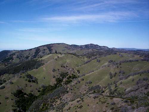
Isabel and Copernicus from Pyramid Rock. Virtually everything visible in the photo is private property.
Camping
There are many campsites at Grant Ranch County Park. Click here for info on camping and reservations.When To Climb
Mt. Isabel is best climbed in the fall, winter, and spring. Summer can be brutally hot, and the west ridge route offers almost no shade. The weather on Mt Hamilton, which is only about 1 mile from Mt Isabel, is available here.Also check out the webcam at Mt. Hamilton. None show Mt. Isabel , but it gives you a look at conditions nearby.
dpletche - Feb 15, 2017 11:37 am - Hasn't voted
acquired by the countyLand between Smith Creek and Mt. Isabel has been acquired by Santa Clara County, in partnership with conservation organizations, and is eventually destined to expand Joseph Grant Park: map details
McCannster - Feb 15, 2017 11:49 am - Hasn't voted
Re: acquired by the countyGreat news! I'll update the main page.