
|
|
Mountain/Rock |
|---|---|
|
|
47.26595°N / 121.12866°W |
|
|
Kittitas |
|
|
Hiking |
|
|
Spring, Summer, Fall |
|
|
4771 ft / 1454 m |
|
|
Overview
Domerie Peak is a popular hiking destination in the western region of Kittitas County, Washington. The peak has a 360-Degree panoramic view of the surrounding area. In particular, the mountain has fantastic views of the Teanaway and Enchantments areas to the northeast, Red Mountain to the north, Mount Baldy and Thomas Mountain to the northwest, as well as Easton Ridge and Mount Rainier to the south. Popular recreational destination Cle Elum Lake is located down the steep eastern slopes of the mountain. Domerie Peak is also a popular hiking destination because of its close proximity to other local peaks. Northern View From Summit...
Domerie Peak is most easily and commonly reached from the Easton Ridge Trailhead #1212. The trail system leading to Mount Baldy begins by switchbacking up the northwestern corner of Easton Ridge along Trail #1212, with ~1100' elevation gain in 0.8 miles. From there, the Easton Ridge Trail heads southeast along its namesake ridgeline, while the Domerie Divide Trail #1308.2 heads northeast towards a trail intersection at "Para Point" (4942'). Trail #1308.2 has ~1350' gain in 1.4 miles. From "Para Point", begin heading southeast along the ridgetop for 1.6 miles, passing Mount Baldy during the traverse, to Domerie Peak via the Domerie Peak Trail #1308. To reach the rocky summit of Domerie Peak involves some YDS Class 2, possibly YDS Class 3 (during inclement weather and/or snowy conditions), on the final summit slopes.
 Approaching The Summit Slopes...
From Domerie Peak, nearby peaks are easily accessible. The nearest peak is Mount Baldy (5107'), a rocky-topped peak located only ~0.5 miles northwest of the mountain. Further northwest, beyond Mount Baldy but still along the same ridge, "Para Point" (4942') is only 1.6 miles away from Domerie Peak, and Thomas Mountain (5269') is nearly three miles away from Domerie Peak.
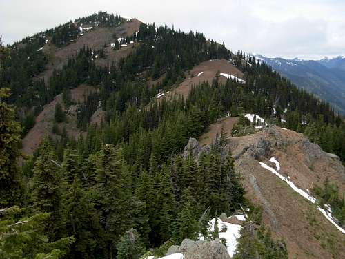 Mount Baldy, As Seen From Domerie Peak
Domerie Peak can be summited year-round. However, the mountain is mainly recommended for Spring, Summer, and Autumn months. The mountain is not recommended during Winter months, as well as periods during snowpack, due to the steep terrain needed to reach the peak.
 Domerie Peak Summit
Getting There
From I-90, east of Snoqualmie Pass:
1) Take Exit 70 ("Easton/ Sparks Road" exit).
2) Briefly head north to a "T" intersection. Take a left turn.
3) Drive approximately one mile to Kachess Dam Road. Take a right turn.
4) Drive approximately 0.8 miles to an unmarked forest road. Take a right turn.
5) Drive approximately one mile along the unmarked forest road to the trailhead for Trails #1212 and #1315.
Red Tape
No parking pass, fee, or permit is required for parking at the trailhead.Trails #1212 and #1308.2 are for hiking use only.