
-
 68013 Hits
-
 84.49% Score
-
 20 Votes
|
|
Mountain/Rock |
|---|---|
|
|
47.45899°N / 121.41654°W |
|
|
Download GPX » View Route on Map |
|
|
King |
|
|
6278 ft / 1914 m |
|
|
Brief History
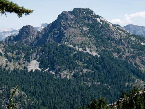
Snoqualmie Mountain seen from The Tooth, August 2006
Round Trip Distance: 5 miles
Elevation Gain: 3,200 ft
Summit: 6,278 ft
Albert Sylvester and a USGS survey party made the first recorded ascent to summit Snoqualmie Mountain in the year of 1898. Along with the Snoqualmie Valley, the Snoqualmie River, and Snoqualmie Falls, the mountain is named after the Snoqualmie Tribe of American Natives. Snoqualmie is a Salish word for the moon. The Natives that roamed the Snoqualmie Valley were known as the people of the moon. Here is an interesting translation of the Snoqualmie legend of The Moon Transformer.
Route Overview
Follow the rough dirt road east for a tenth of a mile watching for the small boot path on the right. You will know it when you see it. This is also the same approach for neighboring Guye Peak. Many hikers knock off both peaks in the same day. The path goes for a few hundred yards and then climbs steeply on a creek bed, roots, talus and all other sorts of stuff, do not expect a well-maintained trail, as this is a climbers path only.
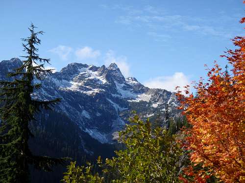 Chair Peak seen from Snoqualmie Mountain, October 2008
After one mile you will come to a junction where the ground cover opens up as it is too rocky for trees and bushes to grow. The right fork leads to Guye Peak and Cave Ridge while main trail continues to the left. There used to be a sign on a tree that shows the way (I’m not sure if it is still there). After another third mile, the trail crosses a creek near a 50 ft waterfall. Don’t count on finding any water here later in summer. A quarter mile from the waterfall the path ascends an open slope (Cave Ridge) and climbs in switchbacks for another mile to the summit. At this point the views to south become impressive. Many people’s first impression at this point is “They consider Guye Peak a separate mountain? It looks like a bump from here”.
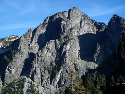 The Northwest Face
Some major peaks recognizable from the summit Granite, Denny, The Tooth, Bryant, McClellen Butte, Chair, Kaleetan, Big Snow, Lemah, Thompson, Chikamin, Chimmney Rock, Hinman, Garfield, Three Fingers, Whitehorse, Baker, Sloan, Glacier Peak, Four Brothers, Stuart, Adams, Rainier.
Driving Directions
Coming east or west, follow I-90 to Snoqualmie Pass. Take exit 52 (West Summit). and if necessary, cross to the north side of the freeway. Skip the first road on the right (which heads to the PCT parking lot). Take the second right and drive up past ski chalets till you get to the Alpental parking lot (about 2 miles from I-90). If you end up cruising through some Swiss looking neighborhoods with vacation homes, you’ll know you took a wrong turn somewhere. Snow Lakes trail head is there and easily visible. 15 feet south of Snow Lakes trail head is a rough dirt road leading up to the Snoqualmie Mountain / Guye Peak trail. A tenth of a mile up this road a small boot path leads off to the right. Usually, depending on vegetation, it does not look like much of a trail head but a few paces in you will know you are on the right track.
 |
 |
 |
 |
 |
 |
When To Climb
Being the highest point in the immediat vicinity, Snoqualmie is best May through December. Be careful when climbing in winter as the ski resort does blast the side of the mountain for avalanches. Check with the Ranger Stations for updated information. Always consider snow conditions and avalanche danger when traveling in the back country.Summit View

Camping / Restrictions
NW Forest Pass Required at TrailheadBackcountry Camping is not officially allowed (as far as I know).
Contact Ranger Station in North Bend for further questions:
North Bend Ranger Station
from Everett (425) 888-1421
from Seattle (206) 622-8378
Mountain Conditions
Washington State Mountain ReportWeb Cams
 |
 |
 |
 |
 |
 |
External Links
- Cascade Climber
Enigma Gully Ski Descent - Cascade Climber
Snoqualmie Mountain and (not) Lundin Peak - Vtrail.com
Washington State Outdoors Guide - Enigma Gully Ski (2/25/01)
Greg's Climbing and Skiing Webpage, Illustrated