
-
 22868 Hits
-
 84.82% Score
-
 19 Votes
|
|
Mountain/Rock |
|---|---|
|
|
36.53805°N / 117.78794°W |
|
|
Inyo |
|
|
Hiking |
|
|
Spring, Summer, Fall |
|
|
9188 ft / 2801 m |
|
|
Overview
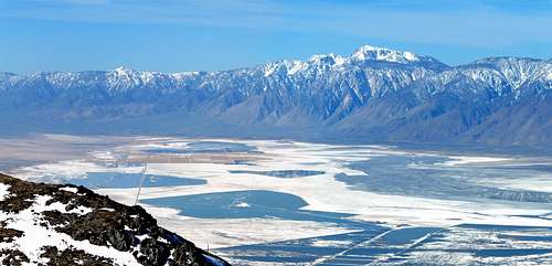 Owens Lake and Olancha Peak from Cerro Gordo Peak
This is a short easy hike to a great viewpoint. To the west is the magnificient eastern scarp of the High Sierra. To the north the crest of the Inyo Range extends almost 40 miles to Waucoba Mountain. The northeastern view looks down on Saline Valley, Ubehebe Peak, and Racetrack Valley. Beyond these are the higher northern ranges of Death Valley National Park. Southeast is the Panamint and Argus Ranges and to the southwest is the vast panorama of Owens Lake topped off by hulking Olancha Peak which dominates the eastern scarp of the Southern Sierra.
Getting There
 East from Cerro Gordo Peak
Hardrockjohn has requested you please check in with Bob or John at the town site. Use the switchback road past the microwave towers. They will be happy to show you the way and tell you about the town.
The route takes the switchback road going up to the saddle between Cerro Gordo Peak and a radio facility peak just south of the town. Go northeast at the saddle and hike the south slope to the summit.
Red Tape
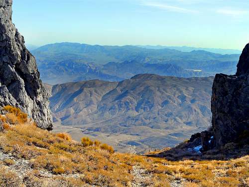
 High Sierra from Cerro Gordo area
There are no permits or restrictions on Bureau of Land Management property.
Camping
 Cerro Gordo town site
There are numerous pullouts along the lower part of the Cerro Gordo road.
Current weather conditions
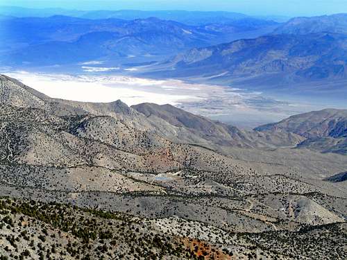 Saline Valley from Cerro Gordo Peak
Further reading on hiking desert peaks
 Racetrack Valley from Cerro Gordo Peak
hardrockjohn - Jun 15, 2010 4:24 pm - Hasn't voted
Cerro GordoPlease don't hike from the saddle to Cerro Gordo Peak. It is PRIVATE PROPERTY not BLM. Check in with Bob or John at the town site, then follow the only legal and safe way to reach the summet. Use the swichback road past the microwave towers. We will be happy to show you the way and tell you about our town, it covers hundreds of acres, not just the few buildings you see. Thank you, Hardrock John
Noondueler - Jun 15, 2010 8:21 pm - Hasn't voted
Re: Cerro GordoThanks hardrockjohn I'll update the directions to the peak to take that into account. ND
Teresa Gergen - Jun 24, 2017 5:18 pm - Hasn't voted
Updated infoAt the townsite, they now want you to sign a liability waiver, and pay a $10 fee per person.
T. White - Sep 28, 2018 11:01 am - Hasn't voted
Re: Updated infoConfirmed, per the mine's new website: http://cerrogordomines.com/ "All visitors must check in with our caretaker, sign a liability waiver and pay for admission before exploring the town."