
|
|
Mountain/Rock |
|---|---|
|
|
38.73937°N / 106.33198°W |
|
|
Chaffee |
|
|
Mountaineering |
|
|
Summer |
|
|
13078 ft / 3986 m |
|
|
Overview

East Face of Peak 13078

South face of Peak 13078 ft from Grizzly Lake

South Face

E/NE Face

North Face

South Face
Rank: Peak 13078 ft is Colorado’s 586th highest ranked peak.
Peak 13078 ft rises to the north of the ghost town of St. Elmo in the Sawatch Mountains of central Colorado near the town of Buena Vista. It sits on the crest of a ridge-line that separates Chalk Creek Valley to the south from South Cottonwood Creek to the north. This ridge-line gives rise to many prominent peaks that remain nameless. To the east, a 12350 ft saddle separates Peak 13078 ft from Peak 13299 ft and to the west, a 12300 ft saddle comes between Peak 13078 ft and Point 12837 ft.
A popular hiking trail starts in the Chalk Creek Valley near the ghost town of St. Elmo and goes up a beautiful little valley known as Poplar Gulch to reach the 12300 ft saddle (and then descends into the South Cottonwood Creek Valley). From the saddle, a well beaten pathway goes up grassy slopes to reach the summit of Peak 13078 ft.
A hike on Poplar Gulch Trail will take you through beautiful forests and meadows. From the summit of Peak 13078 ft, you will have great views of many of the local peaks including the famous fourteeners: Mt. Antero, Mt. Princeton and Mt. Yale.
North Face of Peak 13078
Getting There
From the town of Buena Vista drive 8 miles south on Route 285 to a place known as Nathrop and then turn west onto Route 162. Drive this road 15 miles to the ghost town of St. Elmo (the first 10 miles are paved and the rest is a well graded dirt road). In St. Elmo, cross the bridge to the north side of Chalk Creek and continue to the west end of town. Right at the beginning of Tincup Pass Road, you will see a sign that says “Poplar Gulch Trailhead has been moved ¼ mile up Tincup Pass Road”. With 4WD you can drive up Tincup Pass Road, otherwise park at the beginning of Tincup Pass Road. Hike a very short distance up the road until you see the sign for Poplar Gulch Trailhead.Route (Via Poplar Gulch)
Poplar Gulch Trail can be accessed from the north or the south. This description is for access from the south near the ghost town of St. Elmo. Poplar Gulch |  Map |
All distances are per my GPS (Distance are from trailhead, add 0.25 miles and 100 ft of vertical if you start from St. Elmo)
The trail makes a number of switchbacks and goes up a forest of Pine and Aspen Trees. At times, you can have good views of the mountains on the south side of Chalk Creek Valley.
 |  |
 |  |
At an elevation of 11000 ft, the trail crosses to the east side of the stream. A little farther up, a meadow appears.
 Meadow |  Meadow |  Meadow |
The trail then goes into one last growth of Pine Trees and then reaches a slope that seems to be covered by Bristlecone Trees.
 Bristlecones |  Bristlecones |
At around 12000 ft, the trail goes above tree-line and then reaches the 12300 ft saddle.
 |  |  |
 |  |  |
Poplar Gulch Trail continues north to descend into South Cottonwood Creek Valley. You must leave trail here and follow a well-beaten path up easy grassy slopes to reach the summit of Peak 13078 ft.
Views from the summit of Peak 13078 ft:
 SE/Mt Antero |  South/Mt Aetna |  SW/Mt Helmers |
 W/Mt Emma Burr |  NW/Jones Mtn |  NW/Gladstone Ridge |
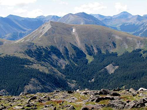
 North/Mt Yale |  NE/Sheep Mtn |  East/Mt Princeton |
Red Tape
No fees or permits for day hikes. For other regulations, see the site for San Isabel National Forest.Weather
See the forecast for the nearby town of Buena Vista.External Links
Poplar Gulch Trail.Poplar Gulch Trip Report and Photos.