
|
|
Mountain/Rock |
|---|---|
|
|
38.73778°N / 106.30543°W |
|
|
Chaffee |
|
|
Mountaineering |
|
|
Summer |
|
|
13317 ft / 4059 m |
|
|
Overview

South Face, (R) Peak 13317 ft & (L) Peak 13299 ft

West Face
South face
Rank: Peak 13317 ft is Colorado's 377th highest ranked peak.
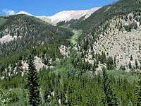
Peak 13317 ft, along with its twin summit Peak 13299 ft, rise to the north of Alpine Lake in the Sawatch Mountains of central Colorado near the town of Buena Vista. They sit on the crest of a ridgeline that separates Chalk Creek Valley to the south from South Cottonwood Creek Valley to the north. This ridgeline gives rise to many notable peaks that unfortunately remain nameless. A 13020 ft saddle separates Peak 13317 ft from Peak 13299 ft.

North Face, (L) Peak 13317 ft & (R) Peak 13299 ft.
Those who go to climb the famous Fourteener Mt. Antero (via Baldwin Gulch) get fantastic views of the twin summits of 13317 and 13299 across the Chalk Creek Valley to the north. I am, however, not aware of any trails that can take you from Chalk Creek Valley (near Alpine Lake) to above treeline. Peak 13317 is best approached from the north where an abandoned mining road can take you from South Cottonwood Creek Valley into Hope Gulch and up to a 12580 ft saddle at the base of the summit of Peak 13317 ft.

South Face, Peak 13317 ft & Peak 13299 ft rising above Alpine Lake
Getting There
From the intersection of Route 24 and Cottonwood Pass Road (the only traffic light) in Buena Vista, drive 7 miles west up the paved Cottonwood Pass Road then turn onto Cottonwood Lake Road which is a well graded dirt road that is passable by most/any car. Follow this road 3 miles until you reach Cottonwood Lake. Continue another 3 miles until you see a spur road on the left (south). You might see a sign for forest road 348 (I will refer to this road as Hope Gulch Road). This is your trailhead (After Cottonwood Lake, the road becomes a little rougher but is still passable by most cars).Route (Via Hope Gulch Road)

The information provided here focuses on hiking the Hope Gulch Road (Forest Road 348). The road is very narrow and potentially dangerous to drive.
All distances are per my GPS.
From the trailhead, hike Hope Gulch Road (FR 348) some 50 vertical feet down the slopes and cross South Cottonwood Creek (In mid August I was able to hop over the rocks without getting wet).

Creek Crossing
The road makes a number of switchbacks going up the slopes in a forest of Aspen and Pine trees. The map shows a total of eleven 180 degree switchback turns until the road reaches an elevation of 11100 ft. A creek that comes down Robey Gulch crosses the road near the beginnings of the road.
 Hope Gulch Rd |  Robey Gulch |
As you go higher, you will get good views of South Cottonwood Creek Valley.
 South Cottonwood Creek |  South Cottonwood Creek |
The road then heads south going into Hope Gulch. Mt. Yale becomes visible to the north.
 Hope Gulch Rd |  Mt. Yale |
At an elevation of 11600 ft, you will reach the remains of an abandoned log cabin in a pine forest.

Abandoned Cabin
At around 12000 ft, you will go above treeline. The 12580 ft saddle comes to view.
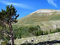
Treeline
Continue up the road to reach the 12580 ft saddle. The summit of Peak 13317 ft appears for the first time. You will also see some of the peaks on the south side of Chalk Creek Valley. You must leave the road here and hike up the slopes of Peak 13317 ft. An ugly two-track scars the beautiful grassy slopes. You can follow this two-track.

Summit from Saddle
Farther up, you must hop amongst the boulders to reach the summit.
 Boulders |  Boulders |
Views from the summit of Peak 13317 ft:
 SE/Mt. Antero |  South/Mt. Mamma |
 SW/Chalk Creek |  West/Peak 13299 ft |  NW/Jones & Gladstone |
 North/Mt. Yale |  East/Mt. Princeton |
Red Tape
No fees or permits for day hikes. For other regulations, see the site for San Isabel National Forest.