
-
 3409 Hits
-
 86.37% Score
-
 22 Votes
|
|
Mountain/Rock |
|---|---|
|
|
41.79382°N / 9.27735°E |
|
|
Corsica |
|
|
Trad Climbing |
|
|
Spring, Summer, Fall |
|
|
3196 ft / 974 m |
|
|
Overview
Geographical classification: Corsica - Corse > Bavella Massif> Punta di U Bracciu
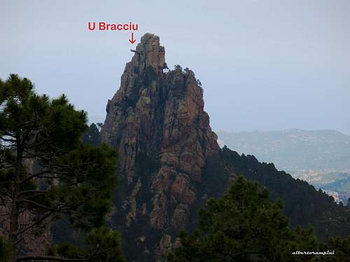
Punta di u Bracciu 974 m
The wilderness surrounded by a vivid blue sea, the rough granite with incredible “tafoni”, the forest of pino laricio: the superb beauty of the Bavella landscape, regarded by many people as the most astonishing amongst the Mediterranean countries, is out of discussion. Everything is wonderful and also a small peak may give an intense emotion: it’s the case of Punta di U Bracciu, a truly curious needle located about 2 km to the East of the mighty Tafunata di Paliri, in the surrounding area of the cute and little Refuge Paliri. This is a bucolic and charming place well known by the trekkers travelling along the GR 20 (Grand Randoneé n.20), a trail crossing Corsica from North-West to South-East.

Punta di u Bracciu - meaning The Arm and named Monte Bracciutu by Fabrikant, one of the greatest expert about the Corsican mountain ranges, is an elegant and low frequented summit coming out the mediterranean bush for about one hundred meters. Therefore it's neither a majestic mountain nor high, but it is quite remarkable in reason of a true natural curiosity: a granite arm 8 meters long protruding perpendicularly from the wall near the Northern summit, the highest, and overlooking Alzolu and u Bracciu valloons.

|

|
Getting There
Access to Corsica
The magnificent island of Corsica-Corse, l'Ile de Beauté (the Island of Beauty) belonging to France but much closer to Italy, can be easily approached by plane (airports both in Bastia on the Eastern coast and Ajaccio on the Western coast) and by ferry-boat from Livorno and Savona italian ports. The most convenient destination in Corsica to visit the Bavella area, one of the wildest region of the island, is the airport of Bastia if you’re getting there by plane; the same Bastia port if you’re getting there by ferry-boat.
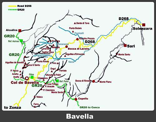
The main entrance into Bavella group is Col de Bavella m. 1211
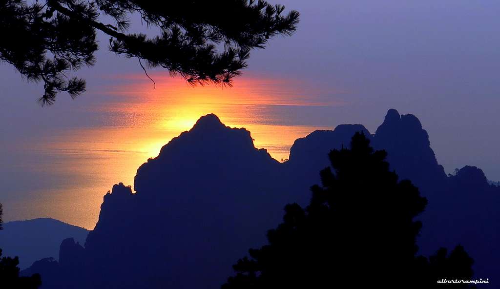
Dawn at Col de Bavella - Sun mirroring on the sea
Road access to Col de Bavella
- From Bastia (Corsica Eastern coast) follow the road RN 198 to Solenzara; a few kilometers before getting to in Solenzara turn to left, taking the road D268 to Bavella Pass (km. 130 from Bastia).
- From Aiaccio (Corsica Western coast) follow the road RN 196 to Petreto, then the road N852 to Aullene, Quenza and Zonza (km. 90 from Aiaccio).

|

|
Walking approach to Refuge de Paliri m. 1055
A - From the Auberge–Gite d’Etape “du Col de Bavella”, situated 500 m. from Bavella Pass along the Solenzara (NE) side of the road D268, follow the forest road starting just behind the hut and joining the GR20 trail; the path descents to reach another forest road, crossing a stream. Follow it for a short distance (about 150 mt.), then turn to right following again the GR20.
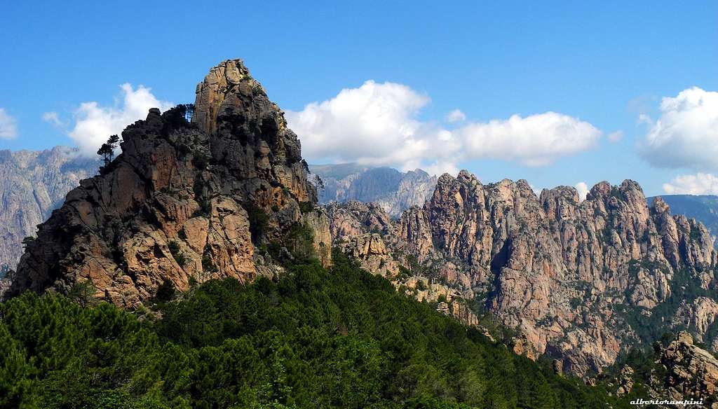
U Bracciu seen from the omonymous saddle
The trail rises across a “pino laricio” forest and reachs Finosa Pass mt. 1195; from here the trail goes down to the beautiful Paliri Hut m. 1055 (water, guarded in summer). 1,30 hours from the “Gite d’Etape”.
B - From the parking along NE side of D268 (Solenzara direction) - at km. 1,8 past Auberge du Col de Bavella - take towards right an unsurfaced forestal road, walking along it for about 2,5 km. and joining the GR20 coming from Col de Bavella. The forest road cross a bed stream, making a semicircle. After about 150 m. leave the forest road and turn to right, following GR 20 as in the previous point.
Route
Punta di u Bracciu Normal route - UIAA scale
Difficulty: AD-, max UIAA III
Length: 120 m
Exposure: SW
First ascent: W. Krah - W. Hertrampf - G. Winkler 1960, september
Starting point: Col de Bavella or Refuge Paliri
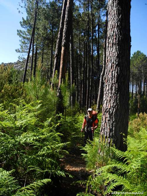
The approach trail |
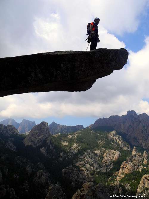
The granite arm hanging over Alzolu valloon |

A brief but fun and nice route on excellent granite. This summit is worthwhile and the environment is superb. It's an advisable destination for climbers staying at Paliri shelter and not to be missed for lovers of the peaks peculiar peaks, little interested in the degrees and the difficulties of the climb. To the thrill-seekers it's strongly recommended the walk to the ends of the arm during the climb up or the descent
Approach from Refuge Paliri - From the hut follow the well worn GR20 path eastwards, getting to the saddle of u Bracciu 850 m, the wooded wide depression located to the South of the spire. From here leave the GR20 and follow briefly to the left an uncertain trail in the direction of the spire, quite visible from the saddle, skirting on the left the base of the rocks and leading to the South-West wall. The starting point is below some large boulders.
Route Report - Climb the boulders and soon reach a collar from which you enter a rocky and vegetated gully. Up the gully with easy scramble to reach the base of a system of chimneys and craks, Climb these latters, giving access to a rocky saddle and a second gully. Follow it to the right, getting the collar between the two summits. A few more meters of easy climb to the summit.
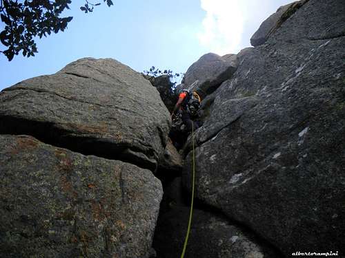
Up the chimneys |
The arm |
Descent - Downclimbing the same route
Red Tape
Bavella Massif is a wonderful world, a well preserved environment, but delicate at the same time, situated inside the Parc Naturel Régional de Corse - Parcu di Corsica. Free camping and bivouac are not allowed and fires are strictly forbidden. Maximum care is required to keep for the future this extraordinary environment.
Climate
Nature is wild and peculiar; in Corsica we can find more than the 5% of authoctonous kinds of flower and plants, in addition to authoctonous fauna. On the contrary, several kinds of animal current inside Mediterranean countries are away from Corsica, like squirrels and vipers.

|

|
Climate is the typical one of the mediterranean middle-mountain areas situated at these latitudes: often very hot in summer and with cold and snowy winters; Spring, early summer and early Fall are the better seasons to climb. Due to Bavella closeness to the sea, winds are often stronger how much they are at the same height in the Alps. Rainfall sometimes are important and dangerous when joined with strong winds. On the contrary, sometimes we can find some long periods of drought. Add When to Climb text here.
Where to stay

The nice Refuge Paliri may be an option. Anyhow it's possible to climb the needle starting directly from Bavella pass. There are several opportunities of accomodation on Bavella Col and surroundings.
COL DE BAVELLA
- Auberge du Col de Bavella – Hotel and Gite d’Etape Auberge du Col de Bavella
- Les Aiguilles de Bavella – Gite d’Etape Gite d'Etape Les Aiguilles de Bavella
ZONZA
– Hotel L’Aiglon, Hotel de la Terrasse, Hotel Incudine
- Residence Le Mouflon d'Or
- Municipal Camping of Zonza, Camping La Riviere (Road to Quenza), Camping Bavella Vista (Road to Quenza)

|

|
Two equipped campsites along the road D 268 between Solenzara and Bocca di Larone:
- Camping U Ponte Grossu - Camping U Rosmarinu
When to climb
Best season to climb Punta di u Bracciu goes from April to middle October.
Meteo
Guidebooks and maps
 |
 |
“Guide d’escalade en Corse” Vol. I Massif de Bavella by Jean Paul Quilici – Bernard Vaucher
Map IGN 4253 ET “Aiguilles de Bavella – Solenzara”