

-
 15437 Hits
-
 90.81% Score
-
 33 Votes
|
|
Area/Range |
|---|---|
|
|
41.79680°N / 9.22504°E |
|
|
Hiking, Mountaineering, Trad Climbing, Sport Climbing, Toprope, Big Wall, Scrambling, Canyoneering |
|
|
Spring, Summer, Fall |
|
|
6230 ft / 1899 m |
|
|
What's new on this page?
PAGINA COMPLETATA CON TRADUZIONE IN LINGUA ITALIANA - THE ITALIAN TRANSLATION ADDED TO THE PAGE (2021, February)
Overview
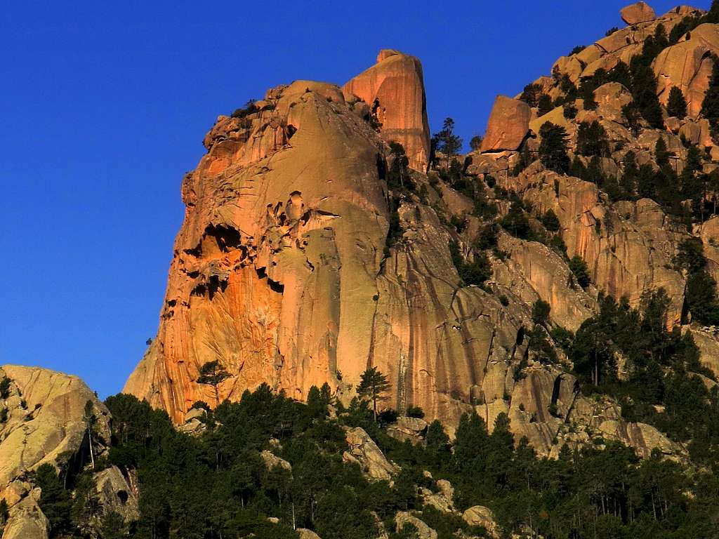
Bavella, a wild world of water and stone
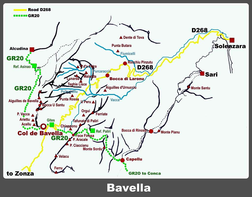
The wonderful granite and water world of Bavella is a wild area located on the mediterranean island of Corsica- Corse. It's one of the finest jewels of the mineral kingdom, a relatively small area lying around the Col de Bavella 1122 m – Bavedda in the local dialect - the highest motorable pass in the Southern Corsica - connecting the Corsica Eastern cost to the region of Alta Rocca. The road access is easily allowed by the road D268, running in the direction NE-SW from Solenzara on the Eastern coast to Col de Bavella and Zonza. It’s very helpful and convenient to divide the massif in two main sectors referring to the position of the various peaks respect to this road: the North-West sector lying on the right of the road (driving from Solenzara to the Col de Bavella) and the South-East sector lying on the left of the road.
The Bavella group is the highlight of the climb in Corsica, both from a sport point of view with the cliffs and the blocks near the Col de Bavella and from the point of view of the adventure terrain with a great variety of routes, more or less well equipped, located in the massif, from the crests of the Velacu group and the towers of the Aiguilles de Bavella on the Northern side to the marvelous granite domes on the side that descends towards Solenzara. The highest summits and faces are situated in the Northern sector of the massif. As told Bavella is surely the showpiece of all Corsica's climbing and one of Europe's granite paradises. Beautiful towers showing an alpine look, like the Tafunata di Paliri, are surrounded by tens of buttresses, high walls, crags and smooth slabs, like Teghie Lisce, peeping out on the lateral valleys. All levels of difficulty are present and the routes are located at various altitudes, so that the good period for rock climbing lasts several months by choosing the most favorable altitude in relation to the season period. In summer, the problem is often to find sheltered ways of the sun (face W) In winter it's possible to climb at low altitude without find the snow, while in summer it's often possible to find some walls sheltered from the heat of the sun.
Il meraviglioso mondo di granito e acqua di Bavella è un'area selvaggia situata nell'isola mediterranea di Corsica, uno dei più bei gioielli del regno minerale. Si tratta di un'area relativamente piccola situata intorno al Col de Bavella 1122 m - Bavedda in dialetto locale - il passo stradale più elevato della Corsica meridionale - che collega la costa orientale alla regione dell'Alta Rocca. L'accesso stradale è agevole grazie alla strada D268, che si snoda in direzione NE-SW da Solenzara sulla costa orientale fino al Col de Bavella e Zonza. È molto utile e comodo dividere il massiccio in due settori principali con riferimento alla posizione delle varie montagne rispetto a questa strada: il settore Nord-Ovest posto sulla destra della strada (salendo da Solenzara al Col de Bavella) e il Settore Sud-Est sulla sinistra della strada.
Il gruppo di Bavella è il top dell'arrampicata in Corsica, sia dal punto di vista sportivo, con le falesie e i blocchi nei pressi del Col de Bavella, sia dal punto di vista del terreno d'avventura con una grande varietà di vie, più o meno attrezzate, situate nel massiccio, dalle creste del gruppo Velacu e le torri delle Aiguilles de Bavella sul versante settentrionale alle meravigliose cupole granitiche sul versante che scende verso Solenzara. Le vette e le pareti più alte si trovano nel settore settentrionale del massiccio. Come detto l'arrampicata in Bavella è sicuramente il fiore all'occhiello di tutta la Corsica e uno dei paradisi di granito d'Europa. Bellissime torri dall'aspetto alpino, come la Tafunata di Paliri, sono circondate da decine di contrafforti, alte pareti, falesie e placche levigate, come le Teghie Lisce, che fanno capolino nelle valli laterali. Sono presenti tutti i livelli di difficoltà e le vie sono dislocate a varie quote, per cui il periodo favorevole per l'arrampicata su roccia dura diversi mesi, scegliendo l'altitudine più favorevole in relazione al periodo stagionale. In estate il problema è spesso trovare vie riparate dal sole (Ovest). In inverno è possibile arrampicare a bassa quota senza trovare la neve, mentre in estate è a volte possibile trovare alcune pareti riparate dal calore del sole.

|

|
From the point of view of hiking it is important to note that the group is crossed by the GR20, the “Grande Randonnée n. 20”, a well known long trekking starting from Calenzana and getting to Conca. Anyhow there are many other possibilities for day trips on foot within the group. If the visibility is good, from the Bavella summits you can see the blue mirror of the Tyrrenian Sea glimming to the East!
The whole of moderate altitude - the highest summit is Punta di u Fornellu m. 1899 - and latitude contributes to create a very singular environment, exalted by the presence of the magnificent and majestic “pino laricio” (Pinus Nigra Laricio), a particular kind of conifer living in the Mediterranean mountainous areas, as Corsica, Sardinia, Calabria and Greece, sometimes reaching the height of 45-50 meters.
Also the “tafoni”, a local word to specify some famous and characteristic rock formations showing the look of granite holes, erosions, strange animals’ shapes, very diffuse inside the Bavella Massif, and other curious rock formations, like grooves and balls, give to the landscape an unmistakable aspect. The highest summits and faces are situated in the Northern sector of the massif.
As we will see in the following paragraphs it would be limiting to reduce the interest of the place only to rock climbing or hiking. In fact, the morphology of this mountainous area makes it possible to carry out numerous other outdoor activities in a context of wild beauty, such as canyoning or mountain-biking, not to mention the extraordinary naturalistic attractions of the region.

Dal punto di vista escursionistico è importante notare che il gruppo è attraversato dal GR20, la “Grande Randonnée n. 20 ”, ben noto lungo trekking con partenza da Calenzana e arrivo a Conca. Ci sono comunque molte altre possibilità di escursioni giornaliere all'interno del gruppo. Se la visibilità è buona, dalle vette di Bavella è possibile vedere lo specchio azzurro del mar Tirreno che brilla verso Est! La moderata altitudine - la vetta più alta è Punta di u Fornellu m. 1899 - e la latitudine contribuiscono a creare un ambiente molto singolare, esaltato dalla presenza del magnifico e maestoso “pino laricio” (Pinus Nigra Laricio), una particolare specie di conifera che vive nelle zone montuose mediterranee, come Corsica e Calabria, a volte raggiungendo un'altezza di 45-50 metri.
Anche i “tafoni”, termine locale per indicare alcune famose e caratteristiche formazioni rocciose con particolari erosioni, che hanno l'aspetto di fori di granito o strane forme di animali, molto diffusi all'interno del Massiccio di Bavella, e altre curiose formazioni rocciose, come solchi e palle, danno al paesaggio un aspetto inconfondibile. Le cime e le pareti più alte si trovano nel settore settentrionale del massiccio.
Come vedremo nei paragrafi seguenti sarebbe limitativo ridurre l'interesse del luogo solo all'arrampicata o al trekking. La morfologia di questa zona montuosa, infatti, consente di svolgere numerose altre attività outdoor in un contesto di selvaggia bellezza, come il canyoning o la mountain bike, senza tralasciare le straordinarie attrattive naturalistiche della regione.
")
|

|
Getting There
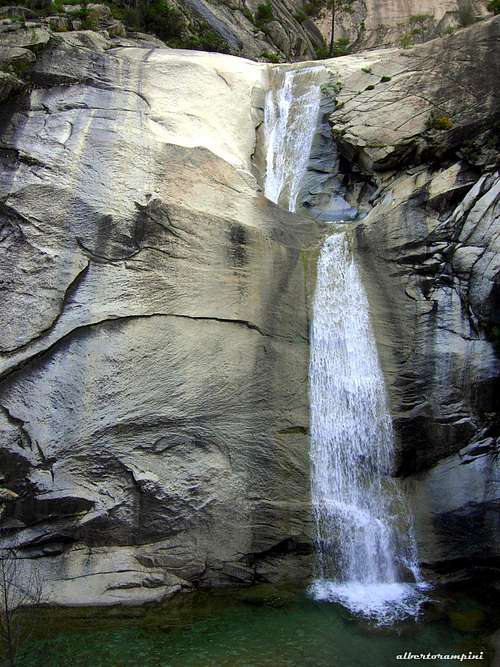
Purcaraccia canyon waterfalls
Access to the island
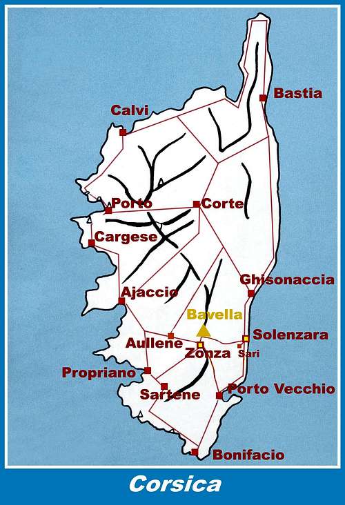
The island of Corse, l'Ile de Beauté (the Island of Beauty), politically belonging to France but much closer to Italy, can be approached by plane (airports in Bastia on the Eastern coast, Calvi and Ajaccio on the Western coast) and by ferry-boat from the French ports of Marseille, Nice, Toulon or from the Italian ports of Livorno, Genova and Savona. The most convenient destination in Corse to visit the Bavella area are the airports of Bastia on the Eastern coast (about 130 km. to Col de la Bavella) and Ajaccio (about 90 km. to Col de la Bavella) if you’re getting there by plane. The shortest way is from Livorno port on Italy Western coast to Bastia port on Corsica Eastern coast, if you’re getting there by ferry-boat.
The main entrance to Bavella group is Col de Bavella m. 1211.
Road approach to Col de Bavella
- From Bastia (Corsica Eastern coast) follow the road RN 198 towards Solenzara; a few kilometers before getting there, turn to right following the road D268 to Col de Bavella (km. 130 from Bastia).
- From Ajaccio (Corsica Western coast) follow the road RN 196 to Petreto, then N852 to Aullene, Quenza and Zonza. From Zonza follow the road D268 to Col de Bavella (km. 91 from Ajaccio).
Come raggiungere l'isola
La Corsica, detta l'Ile de Beauté (l'isola della bellezza), è politicamente appartenente alla Francia ma molto più vicina all'Italia e può essere raggiunta in aereo (aeroporti di Bastia sulla costa orientale, Calvi e Ajaccio sulla costa occidentale) e in traghetto dai porti francesi di Marsiglia, Nizza, Tolone o dai porti italiani di Livorno, Genova e Savona. La destinazione più comoda in Corsica per visitare la zona di Bavella sono gli aeroporti di Bastia sulla costa orientale (a circa 130 km. dal Col de la Bavella) e Ajaccio (a circa 90 km. dal Col de la Bavella) se si arriva in aereo. L'accesso più breve via mare è dal porto di Livorno sulla costa occidentale dell'Italia al porto di Bastia sulla costa orientale della Corsica.
La "porta d'ingresso" al gruppo di Bavella è il Col de Bavella m. 1211.
Accesso stradale al Col de Bavella
- Da Bastia (costa orientale della Corsica) seguire la RN 198 in direzione Solenzara; pochi chilometri prima di arrivare in paese, svoltare a destra seguendo la D268 per Col de Bavella (km. 130 da Bastia).
- Da Ajaccio (costa occidentale della Corsica) seguire la RN 196 fino a Petreto, quindi la N852 per Aullene, Quenza e Zonza. Da Zonza seguire la D268 fino al Col de Bavella (km. 91 da Ajaccio).
Red Tape
Bavella is really a fantastic world, a preserved milieu situated inside the Corsica Regional Nature Park (Parque Naturel de la Corse), established in 1971. Wild camping and bivy are not allowed. Fires are strictly forbidden. Maximum care is required to keep for the future this extraordinary environment.
La Bavella è veramente un mondo fantastico, un ambiente preservato situato all'interno del Parco Naturale Regionale della Corsica (Parque Naturel de la Corse), istituito nel 1971. Il campeggio libero e il bivacco non sono consentiti. I fuochi sono severamente vietati. E' necessaria la massima cura per mantenere per il futuro questo straordinario ambiente..

|

|
Nature and climate
Bavella nature is wild and peculiar; vertiginous granite’s cathedrals rise from impenetrable and secluded valleys, showing impressive faces and unique shapes. Often climbers must fight against the tangled mediterranean vegetation to get to the cliffs. Bavella it’s really the kingdom of wild boar. In Corsica island we can find more than 5% of authoctonous kinds of flower and plants, in addition to authoctonous fauna. On the contrary, several kinds of animal current inside the Mediterranean countries are away from Corsica, like squirrels and vipers.
Climate is the typical one of the mediterranean middle-mountain areas situated at these latitudes: often very hot in summer and with cold and snowy winters; early and middle Spring and early Fall are the better seasons to climb. Due to Bavella closeness to the sea, winds are often stronger how much they are at the same height in the Alps. Rainfall sometimes are important and dangerous when joined with strong winds. On the contrary, sometimes we can try some long periods of drought, especially during late Spring and Summer.

|

|
")
|
La natura della Bavella è selvaggia e particolare; le vertiginose cattedrali di granito si innalzano da vallate impenetrabili e appartate, mostrando pareti impressionanti e forme uniche. Spesso gli arrampicatori devono lottare contro l'intricata vegetazione mediterranea per arrivare alle pareti. La Bavella è pure il regno del cinghiale. In Corsica possiamo trovare più del 5% di specie di fiori e piante autoctone, oltre alla fauna autoctona. Al contrario, diversi tipi di animali comuni nei paesi del Mediterraneo non si trovano in Corsica, come scoiattoli e vipere.
Il clima è quello tipico delle zone mediterranee di media montagna situate a queste latitudini: spesso molto caldo d'estate e con inverni freddi e nevosi; l'inizio e la metà della primavera e l'inizio dell'autunno sono le stagioni migliori per scalare. A causa della vicinanza al mare i venti sono spesso più forti di quanto siano alla stessa altezza nelle Alpi. Le piogge a volte sono cospicue e pericolose se unite a forti venti. Al contrario, a volte possiamo trovare alcuni lunghi periodi di siccità, soprattutto durante la tarda primavera e l'estate.

|
")
|
Main interests: hiking, scrambling, climbing, canyoning
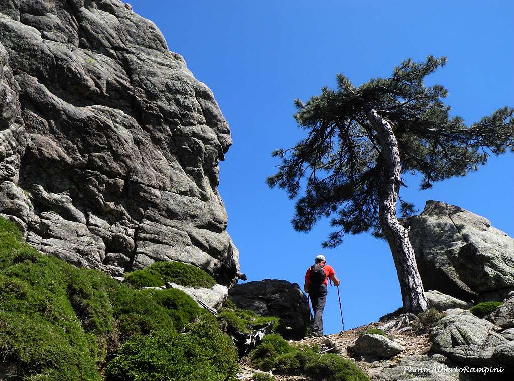
Hiking
The main interests are the treks lasting some days, one day and the half a day walks, M-biking, canyoning and particularly trad and sport climbing, plus scrambling and easy summiting.
Main long trails
- GR20 Grande Randonnée n. 20
The GR20, a well known and long trail starting from Calenzana and getting to Conca, crosses the Massif of Bavella. The GR20 section concerning Bavella massif starts from Alcudina on the North-West, getting the Asinau Hut, Col de Bavella, Paliri Hut and Capellu on the South-East. An Alpine Variant of the GR20 crosses the Aiguilles de Bavella.
- Le Grand Tour des Aiguilles de Bavella – 5 days trekking starting from Solenzara
1st day: Solenzara – Sari (orange marks) 2,30 hours difference in level 411 m. Sari – Pinzutella 1,30 hours difference in level 90 m. / 2nd day: Pinzutella – Tova (orange marks, then cairns) 6 hours difference in level 1230 m. / 3rd day: Tova – Bocca d’Asinao – Bavella (yellow marks) 6 hours difference in level 1218 m. / 4th day: Bavella – Sari (red and white marks) 8 hours / 5th day: Sari – Solenzara (orange marks) 2 hours
Day hikes and short walks
- GR20 Alpine Variant and GR20 circuit
Difference in level: 500 m Duration: 4 hours going and back from Bocca di Pargolu m. 1662 - 7 hours the complet circuit Starting point: Col de Bavella m 1218
One of the best walks starting from Col de Bavella. The GR20 Alpine Variant (Yellow marks) is the wildest section of the hike, developing amongst the Group of Aiguilles de Bavella and reaching the Bocca di Pargolu m 1662. It's possible to come back on the same itinerary or alternatively following the GR20 (Red/White marks).
- U Tafonu di u Compuleddu
Difference in level: 200 m Duration: 4 hours going and back Starting point: Col de Bavella m 1218

|

|
Escursionismo
Gli interessi principali sono i trekking di alcuni giorni, le escursioni di una giornata o mezza giornata, l'M-bike, il canyoning e in particolare l'arrampicata trad e sportiva, oltre allo scrambling su facili vette.
Principali trekking lunghi
- GR20 Grande Randonnée n. 20
Il GR20, noto e lungo trekking che parte da Calenzana e arriva a Conca, attraversa il Massiccio di Bavella. Il tratto di GR20 relativo al massiccio di Bavella parte da Alcudina a Nord-Ovest, arrivando a Sud-Est al Rifugio Asinau, Col de Bavella, Rifugio Paliri e Capellu. Una variante alpina del GR20 attraversa le Aiguilles de Bavella.
- Le Grand Tour des Aiguilles de Bavella - 5 giorni di trekking con partenza da Solenzara
1 ° giorno: Solenzara - Sari (segni arancio) 2,30 ore, dislivello 411 m. Sari - Pinzutella 1,30 ore, dislivello 90 m. / 2° giorno: Pinzutella - Tova (segni arancio, poi ometti) 6 ore, dislivello 1230 m. / 3° giorno: Tova - Bocca d’Asinao - Bavella (punti gialli) 6 ore, dislivello 1218 m. / 4 ° giorno: Bavella - Sari (segni rossi e bianchi) 8 ore / 5° giorno: Sari - Solenzara (segni arancio) 2 ore
Escursioni giornaliere e brevi passeggiate
- GR20 Alpine Variant e GR20 circuit
Dislivello: 500 m Durata: 4 ore andata e ritorno dalla Bocca di Pargolu m. 1662 - Ore 7 il circuito completo Punto di partenza: Col de Bavella m 1218
Una delle migliori passeggiate partendo dal Col de Bavella. La variante alpina GR20 (contrassegni gialli) è il tratto più selvaggio dell'escursione, si sviluppa nel Gruppo delle Aiguilles de Bavella e raggiunge la Bocca di Pargolu m 1662. È possibile tornare sullo stesso itinerario o in alternativa seguendo il GR20 (rosso / Segni bianchi).
- U Tafonu di u Compuleddu
Dislivello: 200 m Durata: 4 ore andata e ritorno Punto di partenza: Col de Bavella m 1218

|

|
Climbing
Bavella is really a wonderful world of stone, therefore it's a great drawn for climbers, due to the amazing granite, the plenty of routes on all the summits of the massif, the beauty of the landscape, the local hospitality. As it's the custom in France, in Bavella group different ways of climb and equipment coexist, and thus we can find routes with different styles and committment, ranging from the modern bolted routes, to the partially equipped routes and trad ones, as well as some sportive routes on the brief cliffs located above Col de Bavella (Secteur Ecole) and near Bocca Ornella.
Arrampicata
La Bavella è veramente un meraviglioso mondo di pietra, quindi è un grande richiamo per gli scalatori, grazie al granito di ottima qualità, alle numerose vie su tutte le cime del massiccio, alla bellezza del paesaggio, all'ospitalità locale. Come è consuetudine in Francia, nel gruppo di Bavella convivono diverse modalità di salita e attrezzatura delle vie, e possiamo quindi trovare vie con stili e impegni diversi, che vanno dalle vie moderne attrezzate a fix, a quelle parzialmente attrezzate e a quelle trad, oltre ad alcune vie sportive sulle brevi falesie sopra il Col de Bavella (Secteur Ecole) e nei pressi di Bocca Ornella.

|

|

|
Easy summits (without rope)
Bavella Massif offers a good terrain of action to the scramblers and experienced hikers, who will find several interesting ascents to easy summits. The following is a brief list about the main peaks that can be achieved with little difficulty and in any case without rope.
- Punta Velacu Normal route - A pleasant and easy way to reach the summit of this beautiful and panoramic mountain, offering wide views over the Bavella range and the Mediterranean Sea.
Difficulty: Alpine F+
Vertical gain: 270 m from Col de Bavella
Starting point: Col de Bavella See the full description of Punta Velacu Normal route": Punta Velacu
- Calanca Murata Normal route - Another advisable and enjoyable route up the summit of this panoramic peak.
Difficulty: Alpine F
Vertical gain: 200 m from Col de Bavella
Starting point: Col de Bavella
Same approach as U Tafonu di U Compuleddu. Once you have visited the wonderful arc, reverse the trail about a hundred meters, then leave it heading rightward to the West side of Calanca Murata. An easy walk leads to the summit.
- Castellucciu d'Ornucciu Normal route
- Punta di A Vacca Normal route
Easy summits (requiring the use of a rope)
- Castellu d'Ornucciu Normal route
- Punta U Diamanti Normal route
- Punta di u Bracciu Normal Route

|

|
Cime facili (che non richiedono l'uso della corda)
Il Massiccio di Bavella offre un buon terreno di azione agli scrambler e agli escursionisti esperti, che troveranno diverse salite interessanti su facili cime. Di seguito un breve elenco delle principali vette che si possono raggiungere con poca difficoltà e comunque senza corda.
- Punta Velacu Via Normale - Un modo facile e piacevole per raggiungere la vetta di questa bella e panoramica montagna, che offre ampie vedute sulla catena del Bavella e sul Mar Mediterraneo.
Difficoltà: F +
Dislivello: 270 m dal Col de Bavella
Punto di partenza: Col de Bavella Vedi la descrizione completa alla pagina Punta Velacu Via Normale ": Punta Velacu
- Calanca Murata Via Normale - Altro itinerario consigliabile e divertente sulla vetta di questa panoramica vetta.
Difficoltà: F
Dislivello: 200 m dal Col de Bavella
Punto di partenza: Col de Bavella
Stesso avvicinamento di U Tafonu di U Compuleddu. Una volta visitato il meraviglioso arco, ritornare indietro un centinaio di metri, quindi lasciare il sentiero dirigendosi a destra verso il versante Ovest della Calanca Murata. Una facile camminata conduce in vetta.
- Castellucciu d'Ornucciu Via Normale
- Punta di A Vacca Via Normale
Cime facili (che richiedono l'uso di una corda)
- Castellu d'Ornucciu Via Normale
- Punta U Diamanti Via Normale
- Via Normale Punta di u Bracciu
, Bavella Massif")
Canyoning
Bavella is also a world of water, showing wonderful canyons and waterfalls, often hidden inside a wild "milieu", as the "Canyon du Monte Tignosu, the "Cascades de Polischellu", the "Ruisseau de Fiumicelli", the "Canyon de La Vacca" and the "Canyon de la Purcaraccia", one of the finest in Corsica.
Canyoning
La Bavella è anche un mondo d'acqua, con meravigliosi canyon e cascate, spesso nascosti all'interno di "ambienti" selvaggi, come il "Canyon du Monte Tignosu, le" Cascades de Polischellu ", il" Ruisseau de Fiumicelli ", il" Canyon de La Vacca "e il" Canyon de la Purcaraccia ", uno dei più belli della Corsica.

|
|
North - West sector main summits
To facilitate the rather complex orientation, here the Bavella group is divided into two large partitions: the NW sector located on the right of the road D268, when driving from Solenzara to Col de Bavella and the SE sector located on the left of the same road.
North-West Sector main subgroups and summits
- Haut Fiumicelli
Main summits: Dente di a Tova m. 1077 - Monte Butara m. 865

|

|
- Purcaraccia
Main summits: Punta Lunarda m. 1276 – Dente di a Purcaraccia m. 981 – Punta di L’Arca m. 1100 - Punta di a Petra m. 1213 – Punta Malanda m. 1166 – Punta d’Arghjavara

|

|

|
- Polischellu
Main summits: Teghie Lisce m. 1025 – Punta di U Corbu m. 1157 – Punta di a Muvra m. 1212 – Punta Polischellu m. 1501

|

|

|
- Contreforts des Aiguilles
Main summits: Petra Sulana m. 1750 – Punta u Specchju m. 1546 – Punta Rossa m. 1209 – Punta A Biciartula – Punta d’U Renaghju

|

|

|
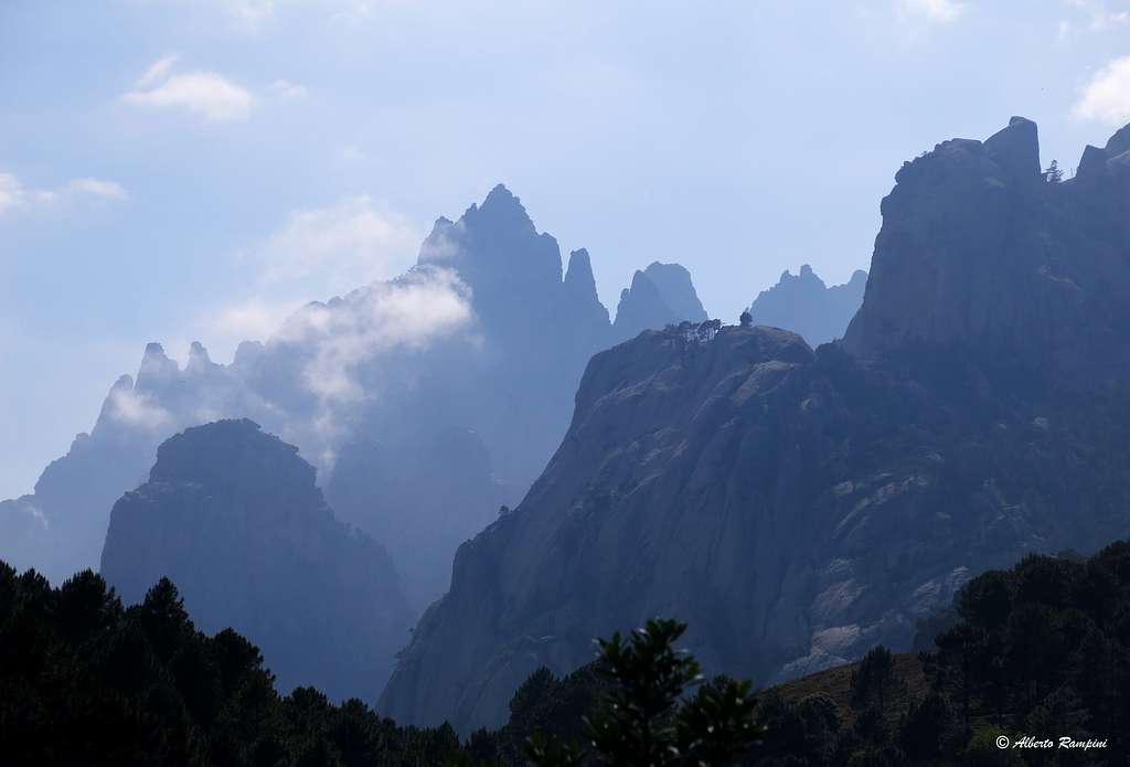
- Aiguilles de Bavella
Main summits: Punta di l’Acellu m. 1588 – Punta di l'Ariettu m. 1591 – Punta d’a Vacca m. 1611 – Punta d’U Pargolu m. 1790 – Punta Lunga m. 1838 – Punta Alta m. 1855 – Punta Iolla m. 1848 – Punta di Pampalonu m. 1753 - Punta Gotcha m. 1750 - Punta di U Santu m. 1785 – Punta Bigornu m. 1450 – Pilastru di l’Alba - Punta di Caracutu

|

|

|

|
Eastern sector main summits
Eastern Sector main subgroups and summits
- Aiguilles d’Ornucciu
Main summits: Castellu d’Ornucciu m. 611 – Castelluciu d’Ornucciu m. 564 - Cima Ghisoni

|

|
- Ferriate
Main summits: U Peru m. 842 – A Zucca – Punta Diputata m. 1051
- Paliri
Main summits: Tafunata di Paliri m. 1312 – Punta Chiapponu m. 1111 – Orgui di U San Petru – Punta Paliri m. 1091 - Punta di U Bracciu m. 974
")
|

|

|

|

|

|
- Velacu
Main summits: Punta d’u Velacu m. 1483 – Calanca Murata m. 1407 – Campanile de Sainte Lucie m. 1375 – Punta Ciaccianu m. 1275 – Punta Aragale m. 1296 - Punta Caletta m. 1275

|

|

|
- Samulaghja
Main summits: Serra di Manzaghia m. 1429 – Punta di Ferru – Punta Samulaghja m. 1480

|

|
- Ospedale
Punta di U Diamanti m. 1227
When to go
Best season goes from the end of April to the end of October; anyhow clear days in spring and fall are the best season to climb and hike here.
Where to stay
COL DE BAVELLA
- Auberge du Col de Bavella – Hotel and Gite d’Etape Auberge du Col de Bavella
- Gite d’Etape "Les Aiguilles de Bavella" Gite d'Etape Les Aiguilles de Bavella

ZONZA
- Hotels in Zonza (Hotel L’Aiglon, Hotel Incudine, Hotel de la Terrasse)
- Renting rooms: Residence Le Mouflon d'Or
- Campsites: Municipal Camping of Zonza, Camping La Riviere, Camping Bavella Vista, Camping Les Aiguilles
- Other campsites along the road D 268: Camping U Ponte Grossu, Camping U Rosmarinu
Huts and Gites on the GR20 trekking
- Refuge d’Asinau (30 beds) - Refuge du Paliri (20 beds) - Auberge du Col de Bavella - Gite d’etape “Les Aiguilles de Bavella”

|

|
Meteo
Useful information
- Rescue 112 Alpine Rescue: Fire Brigade in Zonza 04.95.78.73.10
- Corse Natural Regional Park 04.95.51.79.00
- Meteo 08.36.68.02.20
- Tourist Agency in Zonza and Solenzara 04.95.57.43.75
- Mountain Guides Agency in Quenza 04.95.78.64.33
Guidebooks and maps
Guidebooks (climbing)
 Climbing, hiking and Canyoning Guidebook")
“Bavedda – Aiguilles entre ciel et torrents: Escalade, Rando, Canyon” by Jean Louis Fenouil and Jean Paul Quilici - Ed. FFME
“Rocca è Sole” Massif de Bavedda Jean Paul Quilici – Francis Thibaudeau
"Corse paradis de l’escalade" by Martial Lacroix DCL Editions
"Corse L'ile verticale" by Martail Lacroix - Pierre Sanchou
“Guide d’escalade en Corse” Vol. I Massif de Bavella by Jean Paul Quilici – Bernard Vaucher, Ed. de l’Envol
“Acqua e Petra – Canyons et Escalades en Corse du Sud” by Jean Paul Quilici and Francis Thibaudeau
"Sport climbing in Corsica" by Maurizio Oviglia (Italian and English) Ed. Versante Sud
 |
 |
 |
 |
 |
 |
Guidebooks (hiking)
"Le Grand Chemin - Toutes les étapes du GR 20" - Albiana PNRC
“La Corse, les 100 plus Belles Courses et Randonnées” by Henri Agresti and J. Paul Quilici Ed. Denoel
 |
 |
Maps
IGN 4253 ET “Aiguilles de Bavella-Solenzara”