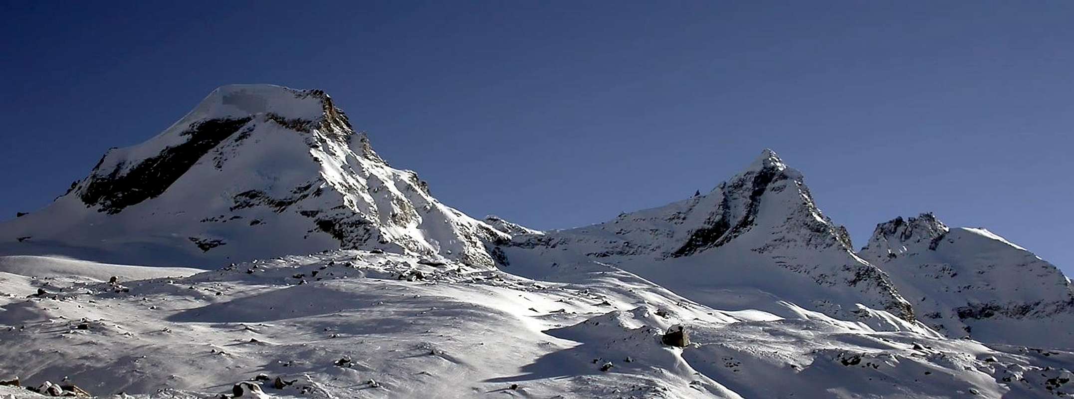
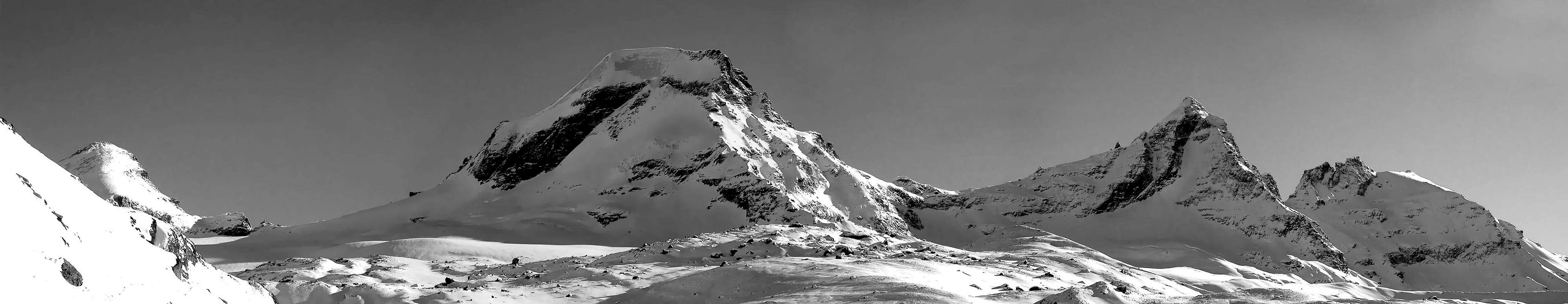
Complex mountain made of four summits: the North Point, two Central Points and the South Point, which is the highest one. Placed between the Monciair Col and the Eastern Grand Etret Col, it is the last southern peak of the Gran Paradiso main range belonging to Aosta Valley. Great view towards the Gran Paradiso Group.
Montagna complessa formata da quattro Sommità: Punta Nord, due Punte Centrali e la Punta Sud, la più elevata. Ultima vetta valdostana a Sud della Catena del Gran Paradiso tra i Colli di Monciair e del Grand Etret Orientale. Ottima vista sul Gruppo del Gran Paradiso.
First Ascents
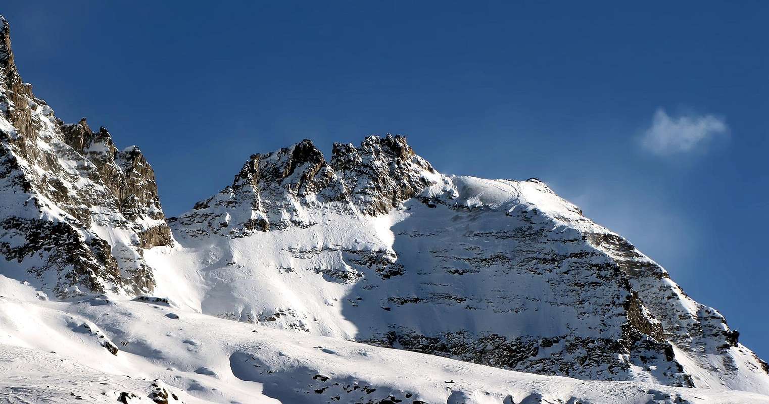
Dente Settentrionale (3.390m):
First on the summit (W-Slope and NE Arête): Maria Andreis, Emanuele Andreis and Renato Chabod, (Jul 23th, 1936).
In winter: Gugliemo Gemello and Damiano Gratton, (Jan 05th, 1969).
Dente Centrale (3.420m):
First on the summit (S Arête ): A. W. Andrews, O. K. Williamson and mountain guide Jean Maître, (Aug 10th, 1900).
In winter: Unknown.
Dente Meridionale (3.454m):
First on the summit (S-SW Arête): Rev, W. B. A. Coolidge, Franz Gardiner and mountain guides Christian Jun. Almer and R. Almer, (Aug 08th, 1889).
In winter: Unknown.
I° Crossing of three Summits (from S to N, partial): A. W. Andrews, O. K. Williamson and mountain guide Jean Maître, (Aug 10th, 1900).
Integral Crossing of three Summits (from N to S): Maria Andreis, Emanuele Andreis and Renato Chabod, (Jul 23th, 1936).
Getting There
BY CAR:
From France: through the Mont Blanc Tunnel or the Col du Petit Saint Bernard: you can drive on SS.26, following directions for Aosta and, before arriving in Villeneuve, turn right towards Introd. Alternatively, you can take Motorway A5 (at Courmayeur or Morgex) and exit at Aosta Ovest.
From all the other directions: get to the Aosta Ovest exit of Motorway A5. Then drive on SS.26 Aosta, in the direction of Courmayeur; just after Villeneuve turn left towards Introd.
BY PLANE:
Aeroporto "Corrado Gex" Saint Christophe (Aosta).
Shortly after Introd, you arrive at a junction: turn left, entering Valsavarenche, and passing through many Villages (Degioz, Eaux Rousses, etc.) you can arrive at Pont (1.960m) where the road ends.
Route
From Pont of Valsavarenche (1.964m), parking nearby the "Camping Pont-Breuil", follow on the right the path n° 2, that skirts to the West side the Torrent Savara and to travel the Seiva or Seyvaz small Valley homonymous alpine pasture (2.176m), known also for alpine Pasture of Grand Etret. Continue with the same, after leaving on the right (Southwest) the trail n° 2A towards La Seyvaz Pasture and Col Collet (2.832m) until it disappears at an altitude of 2.413 meters about into the moraine under the Glacier du Grand Etret. Through a small track, which ends in 2.750 meters altitude and through diagonal route West/East on the glacier (increasingly in retreat in the last thirty years) to go back the Pass Eastern of the Grand Etret (3.150m; 3h'30). To ascend the South-south-west Ridge of Southern Tooth on the corner reaching on rocks routes the great Shoulder (3.421m). To continue on the snowy crest since to a zone with snow or debris to East of the Tooth. To ascend the pass to North and on steep rocks for five meters the corner on the Roc (II°/III°+/PD+/AD- 5h'00/5h'30). In descent: 1 rappel 20 meters.
Da Pont di Valsavarenche (1.964 m), parcheggio presso il "Camping Pont-Breuil", seguire sulla destra il sentiero n° 2, che costeggia sul lato Ovest il Torrente Savara e percorrere tutto il Vallone di Seiva, oppure de la Seyvaz, passando dall'omonima alpe (2.176 m), conosciuta anche per Alpe di Grand Etret. Proseguire con lo stesso, dopo avere lasciato sulla destra (Sudovest) il sentiero n° 2A per l'Alpe La Seyvaz ed il Col Collet (2.832 m) fino a quando scompare a quota 2.413 metri nella morena sottostante il Glacier du Grand Etret. Tramite una piccola traccia, che termina in altitudine 2.750 metri circa, e in diagonale Ovest/Est per il ghiacciaio (sempre più in fase di evidente ritiro in quest'ultimo trentennio) risalire al Colle Orientale del Grand Etret (3.150 m; 3h'30). Salire la cresta Sud-sudovest del Dente Meridionale sullo spigolo raggiungendo su rocce rotte lo Spallone (3.421 m). Proseguire sulla cresta nevosa sino ad una zona con neve o detriti ad Est del Dente. Risalire alla forcella a Nord e su rocce ripide per cinque metri lo spigolo sul versante Roc (II°/III°+/PD+/AD- 5h'00/5h'30). In discesa: una doppia di 20 metri.
Difficulty
The route can be classified as PD+ or AD- depending on mountain conditions.
L'itinerario è classificato PD+ (Poco Difficile+) ad AD- (Abbastanza Difficile-) dipende dalle condizioni della montagna.
Gear
High mountain gear: rope, iceaxe, crampons, helmet and torch.
Da alta montagna, corda, piccozza, ramponi, casco e pila frontale.
Red Tape
Within the borders of the P.N.G.P. (Parco Nazionale del Gran Paradiso), at the moment dogs generally are not allowed, except on a couple of trails, and camping is forbidden (except for climbers from sunset till dawn). No fees are due.
"I Rifugi della Valle d'Aosta" di Stefano Ardito, Ed. Guide iter, Febbraio 2003.
"Parco Nazionale del Gran Paradiso" di Stefano Ardito, Ed. Guide iter, Novembre 2001.
"Guida delle Alpi Occidentali", di Giovanni Bobba e Luigi Vaccarone C.A.I. Sezione di Torino Volume II (parte II), 25 Maggio 1896.
"Gran Paradiso", A. Gegenfurtner, G. Klotz, F. Müller, Ed. Bergverlag Rudolf Rother, Monaco 1980 (in tedesco).
"Gran Paradiso", G. Klotz, Ed. Bergverlag GmbH Rother, Monaco 2005 (in tedesco).
"Diari Alpinistici" di Osvaldo Cardellina e Indice Generale accompagnato da Schedario Relazioni Ascensioni 1964-2019 (inediti).
"Rifugi e bivacchi in Valle d'Aosta", di Cosimo Zappelli aggiornata da Pietro Giglio, Musumeci Editore, Luglio 2002.
"Guida della Regione Autonoma Valle d'Aosta" di Mario Aldrovandi,Ed. S.P.E. di Carlo Fanton, Torino 31 Dicembre 1964.
"Guida dei Monti d'Italia-Gran Paradiso Parco Nazionale" E. Andreis, R. Chabod, M. C. Santis, Club Alpino Italiano/Touring Club Italiano, prima Ed. 1939; seconda Ed. 1963; terza Ed. 1980.
MAPS:
Kompass "Gran Paradiso Valle d'Aosta Sentieri e Rifugi" Carta Turistica 1:50.000.
L'Escursionista "Valsavarenche Gran Paradiso Carta dei Sentieri" (n° 9) 1:25.000.
Meridiani Montagne "Gran Paradiso" 1:25.000.
Enrico Editore Ivrea-Aosta "Gruppo del Gran Paradiso" 1:50.000.
L'Escursionista "Valle di Cogne Carta dei Sentieri" 1:25.000.
L'Escursionista "Tour de la Vallée de Cogne Grand Paradis" 1:25.000.
I.G.C. Istituto Geografico Centrale "Parco Nazionale del Gran Paradiso" 1:50.000.
Studio F.M.B. "Gran Paradiso" Bologna 1:50.000.
I.G.C. Istituto Geografico Centrale Torino "Valsavarenche Val di Rhêmes Valgrisenche P.N.G.P.", 1:25.000.
Parents refers to a larger category under which an object falls. For example, theAconcagua mountain page has the 'Aconcagua Group' and the 'Seven Summits' asparents and is a parent itself to many routes, photos, and Trip Reports.

 6591 Hits
 84.82% Score
 19 Votes