

-
 28899 Hits
-
 94.96% Score
-
 50 Votes
|
|
Mountain/Rock |
|---|---|
|
|
48.65994°N / 113.89423°W |
|
|
Hiking, Scrambling |
|
|
Spring, Summer, Fall |
|
|
7750 ft / 2362 m |
|
|
OVERVIEW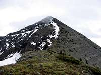 Stanton Mountain Summit Stanton Mountain SummitFirst, the Problem: Stanton Mtn, "only" 7,750' ...then, the Contradiction: Lake McDonald, 3,156'  Stanton Mountain from Apgar Village Stanton Mountain from Apgar VillageStanton Mountain is victim to a contradictory and somewhat deprecating Glacier National Park status. This, despite that the climb is just a few feet less than 4,600' elevation gain, has a good trail the first 2.3 miles, followed by maybe a half mile of bushwhacking—of which only the first 10 or 15 minutes can be termed difficult—leading in turn to more open timber, then to an ascent through an old burn, until finally, tundra and rocks finish the job by leading to a summit with a nice view. The peak is a good early season outing which a moderate, steady pace will do in a bit more than three hours, and in fact combines enough disparate elements to qualify as one of those summits it is safe to label as a good "introductory" Glacier Park ascent.  Stanton Mountain, Solo... Stanton Mountain, Solo...Yet for all this, Stanton Mountain is a stepchild, is considered one of the the park's "minor" mountains, and will always remain such. The problem is that the immediate neighborhood consists of Mount Vaught, Heavens Peak, and  Stanton, Vaught, McPartland... Stanton, Vaught, McPartland...
 Burned trees, Lake McDonald... Burned trees, Lake McDonald...Adding insult to injury is the fact that closest neighbor Mount Vaught (8,850') is considered a much more worthy endeavor, and more often than not is done from Stanton, which at this point has been reduced to merely a check point, a bump in the road, on the way to conquering one of the area’s "majors." And I suppose that's okay; after all, Vaught is indeed a (really) nice mountain; a picturesque saddle (with an elevation loss of around 750') separates the two, and after leaving its ridge and encountering Vaught proper there is well over a thousand feet of impressive cliff work before summiting. All of which leaves Stanton Mountain more or less out of mind and with the underwhelming appellation, succinctly expressed by J. Gordon Edwards (A Climber's Guide to Glacier National Park) as, "This sharp little peak...."  Lake McDonald in silver... Lake McDonald in silver...I've done Stanton twice, and don't feel in the least cheated, as though having done something second-rate. It's not necessary to always climb the "biggies" to experience a rarified environment; experience Stanton's 4,600 feet (with enough steepness you'll regret it if you're out of shape!), and the vista opens up with all the drama and air expected of a place like Glacier; the great peaks are there for the seeing, Lake McDonald is practically at your feet, Mount Vaught—only an arm's length away!—can almost be touched...and taking in the panorama, excitement grows with the imagining of future climbs. I believe "this sharp little peak" to be only relatively diminutive; it is a real gem, and easily and well worth the effort. SUMMIT VIEWSMountains to write home about...
IMPORTANT MISCELLANEOUS INFORMATION Burned Trees, False Summit... Burned Trees, False Summit... Final approach... Final approach...This is a climb which can be ruined by not having insect repellent along. At the point where the trail is left to begin bushwhacking, they can be so bad that unprotected arms will actually be black from the hungry bloodsuckers! It was that way on my first ascent, which was on a chilly day in early June. A year later, when we did the mountain in early July they were still bad, but not so much so. Also, the flies will persist all the way to the summit (although the initial bushwhack area is worst), and do in fact nest on the summit cairn.  West Ridge Route... West Ridge Route...Another bit of miscellany, the advance realization of which can make the climb a bit more enjoyable, is that the descent is all on a west-facing slope, and includes a relatively long stretch through an old burn, so there is no shade. The trail out (substantially lower in elevation, so it's warmer than on top) wraps around the western part of the mountain, and while there is shade at times, it is still uncomfortable. The suggestion here is that if the day looks to be heading for hot and cloudless, get an early start—the afternoon sun can be intense!—and ration your water, so you'll have a bit left for the lower part of the descent.  View through to the summit... View through to the summit...Lastly—and this is just a bit of information relevant to not a lot except beginning climbers in this part of the Rockies—most of Glacier National Park rock is sedimentary, crumbly-rotten, and falling apart. It is vital that handholds and foot placement be carefully tested, and that such caution become a way of life. However...Stanton Mountain is an exception 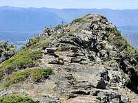 Surmounting the false summit on descent... Surmounting the false summit on descent...
ASCENT VIEWSthis is a very easy mountain on which to find your way to the summit.
GNP ROAD INFORMATION
Map of Waterton/Glacier International Peace Park THE RED TAPE, WILDLIFE, & CAUTIONS SECTION
WHEN TO CLIMB, & CLIMBING CONSIDERATIONS
Because of the nature of the rock, there are special considerations regarding climbing in Glacier National Park, and grading systems unique to the park have been developed by both J. Gordon Edwards and the Glacier Mountaineering Society. Anyone doing more than just "trail" hiking in this part of the Rockies should read the excellent and important information put together by Fred and Moni Spicker. Much—if not most—of the rock in GNP is sedimentary and rotten, and you need to know about it: Glacier National Park Rock & Grading Systems. CAMPING & LODGING
CURRENT MOUNTAIN CONDITIONS/WEB CAMSWeather page—an overview, plus current conditions and forecast This is the New NPS Web Cam Page.
EXTERNAL LINKS/ADDITIONAL INFORMATION/ITEMS OF RELATED INTEREST
In TributeOn March 1, 2011, Vernon Garner, Saintgrizzly, left us after losing a bold, inspiring fight against pancreatic cancer. Or maybe he won, for he is at last free of his pain and has "shuffle[d] off this mortal coil."Vernon was an important contributor on SummitPost, but beyond merely making good, informative pages, he actually inspired many who read his work. No one put more work into his or her pages than Vernon did, and many of those pages, especially those related to Glacier National Park, the place he loved above all others, are works of art in both the writing and layout. More than one person has wanted to visit Glacier or go back to Glacier largely due to what he shared about that magnificent place. Many people on SP counted Vernon among their friends, and many more saw him as one of the best, one of those who exemplified the spirit of this site. He was one of the best of us, he will be missed, and he will not be forgotten. As a tribute to him, Vernon's pages will remain in his name. Any member who sees a need for an addition or correction should please contact site management via the "Send PM to the Elves" feature. Rest well and climb on, Vernon. |


