
|
|
Mountain/Rock |
|---|---|
|
|
49.11850°N / 20.12900°E |
|
|
8257 ft / 2517 m |
|
|
Overview
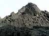
Vidly Widły or Vidlový Hrebeň / Grań Wideł Group it is a group of precipitous summits in a ridge connecting Kežmarský Štít /Kieżmarski Szczyt with Lomnický Štít / Łomnica. A rout going by this ridge is the one of the most difficult “ridge-route” in Tatra Mountains and the one of the most beautiful. In spite of Vidly a much lower than neighboring Kežmarský or Lomnický Štít, their bold shape draws the attension.
Vidlový Hrebeň ascends over Medená Kotlina / Miedziana Kotlina, a branch of Vel’ká Zmrzlá / Dzika Valley, on the north-west and Skalnatá / Łomnicka Valley on the south-east. It is separated from Kežmarský Štít by Kežmarská Štrbina / Kieżmarska Przełęcz and from Lomnický Štít by Medená Štrbina / Wyżnia Miedziana Przełączka. By turns, from the north-east to the south-west, there are following summits (black) and passes (blue):
Miedziany Mur - unfortunately, I didn’t find the Slovakian name
Niżnia Miedzina Przełączka - unfortunately, I didn’t find the Slovakian name
Západná Vidlová Veža / Zachodni Szczyt Wideł
Vidlové Sedlo / Przełęcz w Widłach, 2413m
Vel’ká Vidlová Veža / Wielki Szczyt Wideł, 2517m
Lieviková Štrbina / Wyżnia Przełęcz w Widłach
Východná Vidlová Veža / Wschodni Szczyt Wideł
The Slovakian and Polish name means „pitchfork” and comes from a characteristic ridge’s shape.
 |  |  |
Getting There
FROM SLOVAKIAN SIDE:
The major city in this area is Poprad, where you can get by bus or train. From Poprad there is a lot of buses and trains to Stary Smokovec (13km) at the foot of Tatra:
train time table
bus time table
train time table from Poprad to Stary Smokovec Tatranská elektrická železnica
Maps of Stary Smokovec and Tatranska Lomnica
FROM POLISH SIDE:
The best point to stars the journey is Zakopane – the biggest town on Polish side of Tatra Mountains. You can get there from Kraków by bus (most recommended), car or train:
By bus: there are a lot of buses from Kraków to Zakopane - time table of PKS and private lines Frey and Szwagropol.
By train: the road is much longer and dearer than by bus - time table from Kraków 0.00-11.59 a.m., 12.00-11.59 p.m. and from Zakopane.
By car: from Kraków take a road number 7 to Chyżne and follow it to Rabka. Here this road turn right to Chyżne, but you follow still straight a head in south direction by road number 95. In Poronin 5 km before Zakopane turn left (east) to border crossing point in Łysa Polana.
From Zakopane take a bus to Polana Palenica (time table of PKS, in high season there are a lot of private buses, too – a station is opposite to PKS) and get off in Lysa Polana. Cross the polish-slovak border . Bus station on Slovak side is about 100m after border crossing point on the right. Take bus to Poprad, which goes through Bela Voda, Tatranska Lomnica and Stary Smokovec (time table) and get off in Bela Voda.
IN MOUNTAIN:
Approach to Chata pri Zelenom Plese:
Take a bus from Stary Smokovec to Lysa Pol’ana and get off in Bela Voda. There is only a little parking-place among a forest and beginning of yellow marked trail, leading to Chata pri Zelenom Plese (about 2 h 45 min).
Approach to Skalnata Chata:
Take a green-marked trail from Tatranska Lomnica to Skalnata Chata (about 2 h 15 min) or take a cable-car (time table and price) – 12 min.
 |  |  |
Maps

Map of Vidlový Hrebeň’ area
Tatry Wysokie, in scale 1:25 000, description in 6 languages, ISBN 83-87873-26-8, available in all shops in Zakopane. Here you can look at net version.
A high quality maps in scales 1:25 000 and 1:50 000 are produced VKU Harmanec, too. They are available at all chalets and shops in cities under Vysoke Tatry.
When To Climb
The best time to climb Vidlový Hrebeň is summer and early autumn (june-september).
 |  |  |
Red Tape
The “High Tatra” is a National park, UN Bioheritage area and a European BioHeritage - if you are not a member of any climbing club you can move only on marked trails - so you can visit Vidly only with Tatra guide.
In winter time (from November the 1st – June the 15th) The Tatra Mountains in slovakian part are closed for normal tourists.
For more informations look at High Tatra/Vysoke Tatry GROUP page.
For climbing regulations look at Gerlachovsky Stit page.
Accommodation
There are two chalets near by Kežmarský Štit:
Chata pri Zelenom Plese (“Brincalka”) situated in Bielej Vody Kezmarskej (Kiezmarska) Valley on the eastern bank of the Green Mountain-Lake („Zelene Pleso”). Chalet is opened all the year for hiking, climbing and ski mountaineering.
Access from:
• Tatranske Matliare, blue marked path (3 h 30 min)
• Bela Voda, yellow marked trail (2 h 45 min)
• Skalnate Pleso, red marked trail (2 h 15 min)
• Tatranska Kotlina through Chata Plesnivec, green/red trail (3 h 30 min)
• Tatranska Javorina through Kopske Sedlo, blue/red marked trail (4 h)
Contact:
Telephone: ++421-52-4467420
mobile: ++421-903-467420
Email: jgantner@stonline.sk
Skalnata Chata situated in Lomnicka Valley on the eastern shore of Skalnate Pleso. Chalet is opened all the year for hiking, climbing and ski mountaineering.
Access from:
• TatranskLomnica, green-marked trail (2 h)
• Chata pri Zelenom Plese, red-marked trail (2 h)
• Hrebienok, red-marked trail (2 h)
Contact:
Telephone: ++421-52-4467075
Absolutely no camping is permitted in the nature park. The nearest camping is in Stara Lesna and Tatranska Lomnica.
There are plenty of cheap hotels and pensions in the area of Stary Smokovec and Tatranska Javorina.
accomodation
 |
Mountain Conditions
Web forecast:
situation at this moment and forecast
Information of avalanche danger:
TOPR (in English) and HZS
Rescue:
On Slovakian side acts HZS (Horska Zachranna Sluzba)
Starý Smokovec 23, 059 60 Vysoké Tatry
phon.: 052/4422820, fax: 052/4422855,
mobil: 0903624869
e-mail: vtatry@hzs.sk
www.hzs.sk