
|
|
Area/Range |
|---|---|
|
|
Overview
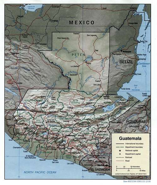
Map of Guatemala
Guatemala is the westernmost country of Central America. It is bounded on the west and north by Mexico, on the east by Belize and the Caribbean Sea, on the southeast by Honduras and El Salvador, and on the south by the Pacific Ocean. It is the third largest nation in Central America, after Nicaragua and Honduras.
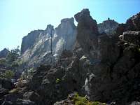
Two mountain chains cross Guatemala from west to east, dividing the country into three major regions: the western highlands, where the mountains are located; the Pacific coast, south of the mountains; and the Petén region, north of the mountains.
The southern edge of the western highlands is marked by the Sierra Madre range, which stretches from the Mexican border south and east, almost to Guatemala City. It then continues at lower elevations toward El Salvador, in an area known as the Oriente. The mountain chain is noted for its steep volcanic cones, including Tajumulco, the highest point in the country and Central America. Most of Guatemala’s active volcanoes are in this chain, and earthquakes occur frequently in the highland region.
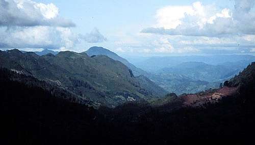
The Sierra Madre range
The northern chain of mountains begins near the Mexican border with the Cuchumatanes range and stretch east through the Chuacús and Chamá mountains and slopes down to the Santa Cruz and Minas mountains near the Caribbean Sea. The northern and southern mountains are separated by a deep rift, where the Motagua River and its tributaries flow from the highlands into the Caribbean.
Sierra Madre de Chiapas
From jaguars to harpy eagles, these wild jungles and cloud forests support a wide diversity of life. This range is home to some 750 species of plants, 22 amphibians, more than 60 reptiles, over 100 mammals, and well over 300 species of birds. These forests are also known to be home to many species of butterflies and salamanders that live nowhere else on Earth and is one of the largest fragments of intact mountain forest in all of Mexico, Guatemala, and El Salvador.
Cuchumatanes Range
Running north-west to the Mexican border is the Sierra de los Cuchumatanes, the highest range in Central America. The whole area is usually shrouded in clouds, but these mountains are also steeped in history. Guatemala was at the heart of the Mayan empire which, towards the end of the first millennium, also encompassed much of Belize and parts of Mexico, Honduras and El Salvador and began to fall apart in the 11th century. It was in these mountains, in 1524, that the Quiche, still the most numerous of the country's 26 indigenous peoples, were defeated by an army led by Spanish conquistador Pedro de Alvarado.
There are nine smaller mountain ranges in Guatemala: Sierra Los Cuchumatanes in Huehuetenango and Quiché (above 3,900m.); Sierra de Las Minas in El Progreso, Baja Verapáz, Alta Verapáz, Zacapa and Izabal (2,987 meters); Sierra de Chamá in Alta Verapáz (2,645 meters); Sierra de Chuacús in Quiché and Baja Verapáz (2,504 meters); Sierra de Santa Cruz in Izabal (1,210 meters); Sierra del Espiritu Santo in Zacapa and Izabal (1,486 meters); Sierra del Lacandón in Petén (636 meters); Merendón mountains in Izabal (1,144 meters); and Mayan mountains in Petén and Belice (above 900 meters).
Too Short A History
Guatemala’s history is all about the Maya. Mayan “centers” were spread across Peten until the 9th century A.D. The Mayan, whose writing system was the most advanced in the Americas during their time, left their mark via hieroglyphic writing, sculptures and a progression of pottery. The Mayan lasted the longest and the left the most signs of their existence of any culture in Central America. Their kingdom lasted from 1000 to 300 B.C. One of the most impressive signs of the Maya is their building development. Today, we know that the Maya didn’t use wheels in the practical sense, but carried such stones as limestone on their backs, to create massive structures, such as the temple pyramids in Tikal.
The Maya built elaborate cities just about everywhere on most any kind of terrain. In addition to buildings, Maya eventually mastered crop engineering, turning swamps into flourishing fields yielding corn, yams, ramon nuts, and forest fruits.
Other cultures that flourished in other parts of Mesoamerica were the Toltec, Olmec, and Mixtec. Today, the people of Guatemala include Ladinos, Indians, Red Caribs, and Black Caribs, the history of which is quite intricate.
After almost three centuries as a Spanish colony, Guatemala won its independence in 1821. During the second half of the 20th century, it experienced a variety of military and civilian governments as well as a 36-year guerrilla war. In 1996, the government signed a peace agreement formally ending the conflict, which had left more than 100,000 people dead and had created some 1 million refugees.
Getting There

Many airlines fly into Guatemala, including Iberia, KLM, American, and Delta. There are two major airports that serve international passengers: Guatemala City and Flores. The Flores airport serves passengers visiting the northern regions of Guatemala especially those wanting to see Tikal. Guatemala has just finished building a beautiful new airport terminal in Guatemala City. When you arrive at the airport, you will first go through Immigration, the lines can be long so be patient. After your passport is stamped, you will pick up your luggage and go through customs. Make sure you have your baggage receipts on hand or they will not let you leave with your luggage. Upon exiting the airport you will be accosted by people offering you taxi rides. The best solution is to have prearranged a pick-up prior to arriving. However, if you need a ride, accept the services of people who are driving real taxis and who have approved identification. Yellow taxis are the best and white taxis come in second for safety. Negotiate your fair in advance or make sure there is a meter in the car that works. Never accept a ride from someone who is not driving a taxi! You will get robbed and maybe hurt.
It is also possible to travel overland by bus from any of the neighboring countries: Mexico, El Salvador, Nicaragua, Costa Rica. You can also drive there via the Pan American Highway, which runs through Guatemala from Mexico in the north to El Salvador in the south.
Guatemala has no railway service. The most efficient way to travel is to take internal flights from Guatemala City and Flores on these airlines: AVIATECA, Aerocaribe, Aerovias. Guatemala also has a relatively cheap and easy-to-use bus service running throughout the country. However, during the rainy season, this cannot be relied on as some of the roads may become impassable or disappear altogether. Also, the bus drivers have a reputation for fast and reckless driving.
For more information, go to the Fact Sheet on getting around in Guatemala.
Red Tape
Most international visitors can visit Guatemala for up to three months without first obtaining a visa. There is a US$30 (or quetzal equivalent) airport departure tax that is payable at airline check-in desks.
Health Risks
Always seek up-to-date medical advice from your doctor or a travelers' health centre.
Malaria is present in some parts of Guatemala, particularly in the lowland regions that are popular with tourists. Anti-malarial medication should be taken while visiting the country. Dengue fever is endemic in the country, so mosquito repellent should be worn and as much clothing to cover the skin as possible.
There are two kinds of hospitals in Guatemala, public and privately owned. Avoid the public hospitals if at all possible. Private Guatemalan hospitals are reluctant to give treatment unless they have proof of satisfactory medical insurance. They have no legal obligation to treat you. It is therefore important to take out comprehensive medical insurance and carry documentation with you at all times. In addition, many hospitals and medical services are provided on a pay as you go or a-la-carte basis. You may have to pay for your care and then seek reimbursement from your insurance provider. Also, being a foreigner with insurance, or if they figure you can pay the hospital bill, you run a high risk of getting over-treatment if you visit a hospital. Things to watch out for are unnecessary surgery just to be sure, hospitalization in a private room with TV to get rest, unnecessary test like an aids-test for diarrhea.
It is also advisable to drink only bottled water and to eat only fruit and vegetables that have been washed and peeled.
A Word of Caution
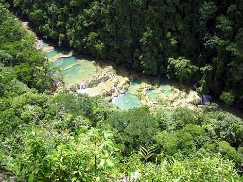
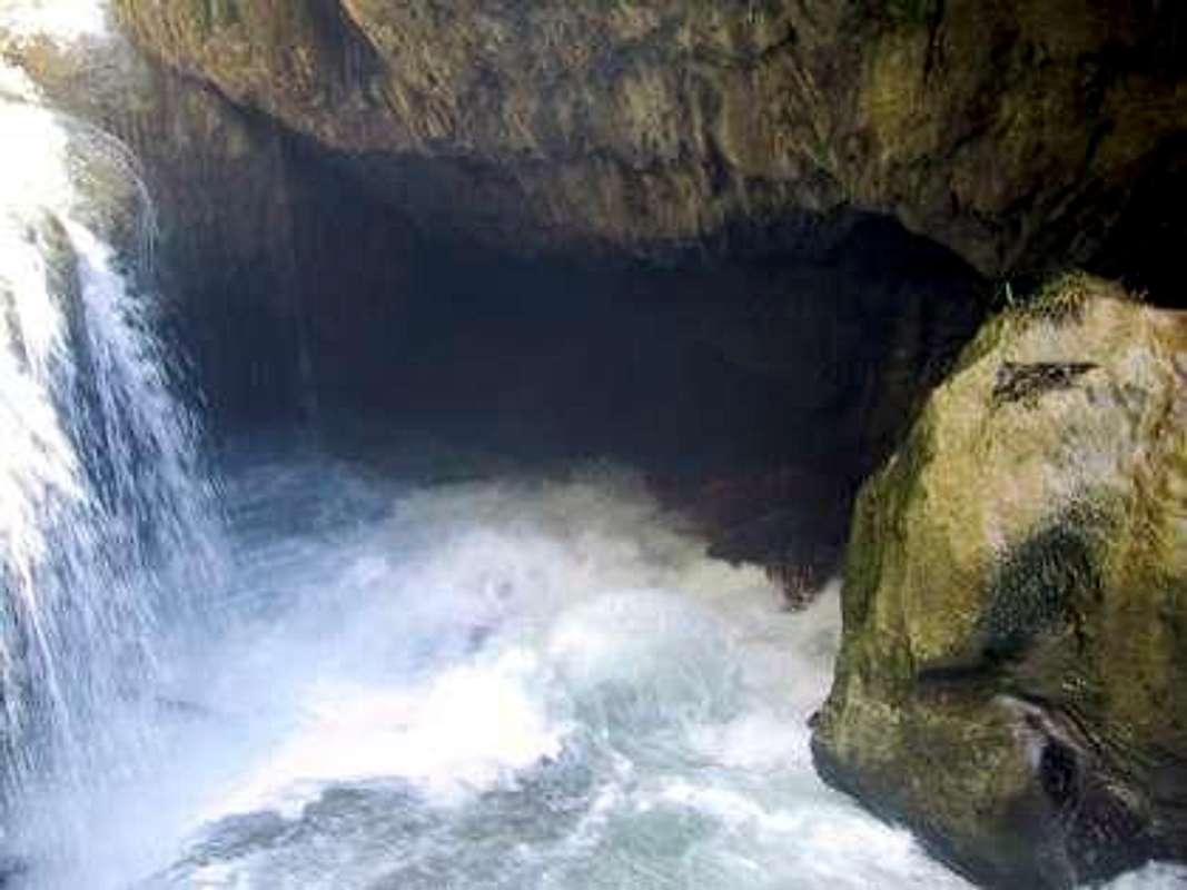
Semuc Champey
Guatemala still bears the scars of over thirty years of civil war and unrest. While the Peace Accords have been signed, severe inequality and poverty are everywhere and few people trust law enforcement and the legal system. Crime is a serious problem in the country and violent crimes are rapidly on the rise, especially rape. If you are robbed, do not resist, you will get hurt or killed. These people are not bluffing when they say they will use a gun or knife. Avoid traveling at night. Visitors should always be vigilant and prepared. In addition, the country is prone to extreme weather conditions, earthquakes, and several volcanoes are still very active.
Be extremely careful about taking pictures of children. There have been instances where tourists were taking pictures of cute kids and found themselves under attack by an angry and suspicious mob. Many people, especially in the countryside, believe that tourists come to Guatemala to steal their children.
All that being said, Guatemala is a wonderful country to visit and many people travel throughout the country without any problem.
Camping
There are very few camping facilities in Guatemala. Those that do exist are privately owned and generally appear to be an afterthought associated with some larger tourist development. Be careful of facilities that sell themselves as ecotourist facilities. Camping on private property is possible and some fincas (large farming estates) welcome campers. Make sure you talk to the owner or manager of the property before you set up tents or you may find yourself surrounded by a bunch of cowboys demanding payment for their protection. Camping on many of the volcanoes of Guatemala is popular, especially on Acatenango, Pacaya, Tacana, Agua, and Ipala. There is no fee for doing this and there are no services. As always, be alert and careful when camping. There is no 911 in Guatemala.
High Points
Top 10 Mountains
| Name | Elevation | Latitude/Longitude | |
|---|---|---|---|
| 1 | Cerro Cotzic, San Marcos | 3171m | 15.18/-91.9 |
| 2 | Siete Cruces,Solola | 3113m | 14.78/-91.41 |
| 3 | Tojchij, San Marcos | 3112m | 15.18/-92.01 |
| 4 | Tuicacaix, Quetzaltenango | 3084m | 14.85/-91.66 |
| 5 | Candelaria, Quetzaltenango | 3056m | 14.8/-91.51 |
| 6 | Cumbre Maria Tecun, Totonicapan | 3016m | 14.86/-91.21 |
| 7 | Cerro Tecpan, Chimaltenango | 2953m | 14.78/-91.01 |
| 8 | Cerro Serchil, San Marcos | 2949m | 15.03/-91.8 |
| 9 | Cerro Raxon, Alta Verapaz | 2948m | 15.15/-89.73 |
| 10 | Cerro Yolquen, Huehuetenango | 2930m | 15.9/-91.55 |
Top Ten Volcanoes
| Name | Elevation | Latitude/Longitude | |
|---|---|---|---|
| 1 | Tajumulco, San Marcos | 4220m | 15.044/-91.904 |
| 2 | Tacana, San Marcos | 4092m | 15.13/-92.10 |
| 3 | Acatenango, Chimaltenango | 3976m | 14.30/-90.52 |
| 4 | Santa Maria, Quetzaltenango | 3772m | 14.758/-91.54 |
| 5 | Volcan de Agua, Escuintla | 3765m | 14.465/-90.74 |
| 6 | Volcan de Fuego, Chimaltenango | 3765m | 14.28/-90.52 |
| 7 | Atitlan, Solola | 3557m | 14.6/-91.2 |
| 8 | Pico Zunil, Quetzaltenango | 3542m | 14.46/-91.27 |
| 9 | Santo Tomas, Quetzaltenango | 3505m | 14.71/-91.47 |
| 10 | Siete Orejas, Quetzaltenango | 3370m | 14.49/-91.37 |
Rock Climbing
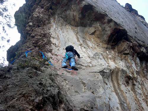
There are a number of places in Guatemala where you can rock climb and Guatemala is home to a growing group of dedicated climbers who are working hard to open new areas and routes. Below are descriptions of the three major areas. Information and descriptions come from Daniel Du Toit, Aaron Bergman, and myself.
Huehuetenango
Las Ventosas is a series of limestone boulders found high up in the Cuchumatanes Mountains past the small community of La Ventosa. A few problems have been established ranging from V0-V3 on different boulders but the potential is unlimited and highball is the name of the game. Be sure to bring some wire brushes and plastic ones to clean moss and dirt off where new problems can be made and don't scrub too much or else it can be possible to give the holds a "new" texture. Be careful if you venture to find new lines on the boulders higher up in the hill as some of the limestone is rotten and no good. Be sure to let someone know at the small tienda across the road from "la casona" that you are exploring the area and just climbing for fun.
The Piedras Cuaches area is very underdeveloped, there are many limestone boulders. You do have to do some hiking to get there and at 10,000+ feet, prepare to get a little winded. There are no clear trails so you will have to do some bushwhacking. The two areas are 1.The huito boulders, two boulders with tons of problems on them. They are on the trail to the Piedras Cuaches and 2. A set of boulders that are totally underdeveloped to the east of the Piedras Cuaches, really close to the road to San Juan Ixcoy on the same "mountain." It is very important that you ask the local cooperative at the entrance of the area for permission to enter, especially if you plan on camping out. This area has gone through many territory disputes, and the last thing they need is a gringo looking like he's going to buy the place.
Lake Amatitlan

There are over 20 routes ranging from about 5.8 to 5.12. The routes are generally crimpy and the rock ranges from slightly under vertical to slightly overhanging. The rock is sedimentary with some parts good and other parts very chossy. There is potential for more routes. From the road the cliff doesn’t look all that great, but it is worth the hike. The first cliff you come to has some fun short relatively easy routes as well as a couple of bouldering opportunities. The best and hardest routes are higher up. Other routes will be found scattered throughout the area. Many of the routes are bolted and suitable for top roping. There are a handful of multi-pitch routes very high up. If you climb here, be prepared to get dirty! In the rainy season, the temperatures are good the whole day but there can be afternoon showers.
This place has the best developed rock climbing in the country. It is definitely worth checking out if you are visiting Guatemala. The city of Quetzaltenango (Xela) is a perfect setting to take some Spanish classes and do a little climbing. The crag begins at over 9000 feet and offers some spectacular views of the countryside! Routes start at 5.9 and go to 5.12, though the locals may rate some of them 5.13. There is also a 5.14 project underway. The potential exists for new routes and the local climbers are working hard to add new lines. Most of the routes are bolted but there is some potential for gear routes. There are boulders everywhere though many are sharp and chossy. Most of the landings are bad, so a pad and spotter is advisable.
National Parks

Even though it is known that the Guatemalan government’s conservation efforts might be less of a priority than their attention to foreign investment, is has been a topic of concern at times in Guatemala. There is an organization working full time towards protecting the biological diversity in Guatemala. The organization is called the Defensores de la Naturaleza, which owns and protects the Reserva de la Biosfera de Sierra de las Minas. Thankfully, there have been some National Parks established over the years.
Maya Biosphere Reserve was founded in 1990 and includes many protected areas, including Tikal National Park and Rio Azul National Park.
Parque Nacional Lachua is located 418 kilometers by car from Guatemala City and includes a subtropical rainforest with mahogany, breadnut, and ceiba trees. Raccoons, coatis, peccary, and macaws are among the species of wildlife found in this park.
Parque Nacional Rio Dulce is a park based around the river that flows into the Caribbean. It covers 80 kilometers of land. Visitors may have the opportunity to observe mollusks, tapirs, alligators, manatees, spider monkeys, and turtles.
Other parks include the Pacaya Volcano Park and Lake Atitlan Park.