
|
|
Mountain/Rock |
|---|---|
|
|
49.19806°N / 20.22694°E |
|
|
Hiking, Mountaineering |
|
|
Spring, Summer, Fall, Winter |
|
|
7717 ft / 2352 m |
|
|
This peak doesn´t belong to the highest mountain in this area, and is often neglected. But it is missing piece of SP list of Tatras mountains, so I´ve decided to create a page dedicated to this peak, but due to lack of pictures I´ve used the pictures of other SP members (Tomas Kristofory, Tomek Lodowy, Blaze334, Visentin, julesblaidd and others.
![Kezmarske peaks and Huncovsky Stit from Veľká Svišťovka]() Huncovský štít on the left (image by visentin)
On the slopes of this peak, there is an astronomical observatory of the Slovak Academy of Science.
Huncovský štít on the left (image by visentin)
On the slopes of this peak, there is an astronomical observatory of the Slovak Academy of Science.
![Would you like to live here?]() Lomnický štít group. From left: Baranie rohy, Spišský štít, Pyšný štít, Lomnický štít, Vidlové veže, Kežmarský štít and Huncovský štít (the peak with snow covered slopes) ... image by Tomas Kristofory
First known ascents:
G. Dyhrenfurt, A. Martin - 8.3.1906 - from Huncovské sedlo
A. Grósz, A. Thern - 18.3.1921 - from Huncovská kotlina
Lomnický štít group. From left: Baranie rohy, Spišský štít, Pyšný štít, Lomnický štít, Vidlové veže, Kežmarský štít and Huncovský štít (the peak with snow covered slopes) ... image by Tomas Kristofory
First known ascents:
G. Dyhrenfurt, A. Martin - 8.3.1906 - from Huncovské sedlo
A. Grósz, A. Thern - 18.3.1921 - from Huncovská kotlina
![Lomnicky Stit from Tatranska Matliar]() Huncovský štít is the first peak on the right, in front of Kežmarský štít. (image by julesblaidd)
Climbers can find interesting routes in the western face (Western pillar).
Huncovský štít is the first peak on the right, in front of Kežmarský štít. (image by julesblaidd)
Climbers can find interesting routes in the western face (Western pillar).
![Lomnicky Stit]() Huncovský štít is the first peak on the right. (image by Blaze334)
Huncovský štít is the first peak on the right. (image by Blaze334)

Overview
Huncovský štít - Huncowski szczyt - Hunsdorfer Spitze - Hunfalvi csúcs It is a broad peak at the end of a side ridge leading from Kežmarský štít in SE direction. It is divided from Kežmarský štít by Kežmarská priehyba and Huncovské sedlo Pass (2307 m). Huncovský štít separates Skalnatá dolina Valley from Huncovská kotlina Basin. It has moderate southern and south-eastern scree slopes which made this peak easy accessible. This peak has two summits: north-western (lower) and south-eastern (main summit - 2352 m), separated by Huncovská štrbina. Huncovský štít is often visited by hikers, who are going further to Kežmarský štít. Huncovský štít on the left (image by visentin)
 Lomnický štít group. From left: Baranie rohy, Spišský štít, Pyšný štít, Lomnický štít, Vidlové veže, Kežmarský štít and Huncovský štít (the peak with snow covered slopes) ... image by Tomas Kristofory
Climbing and hiking
As I wrote earlier, this peak is easy accessible via its moderate southern slopes above Skalnatá dolina Valley; from Huncovské sedlo, from Skalnatá dolina Valley and from Huncovská kotlina Basin. Skalnatá dolina is easy accessible by cable car from Tatranská Lomnica (850 m) or by green marked trail from Tatranská Lomnica (2 h 45 min)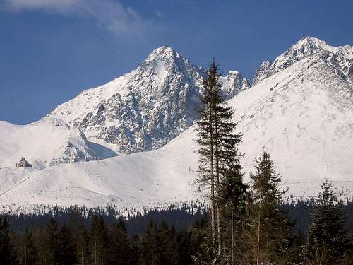 Huncovský štít is the first peak on the right, in front of Kežmarský štít. (image by julesblaidd)
 Huncovský štít is the first peak on the right. (image by Blaze334)
Red Tape
The whole area is a protected landscape and a part of High Tatras National Park, so it is forbidden for non-climbers. Even climbers cannot use routes with difficulty less than III grade of UIAA, except from access paths. Tatra National Park RegulationsMountain Rescue Team
HZS Vysoké Tatry Starý Smokovec 23 059 60 Vysoké Tatry tel.: +421 52/4422820, fax: +421 52/4422855, mobile: +421903624869 e-mail: vtatry@hzs.sk Avalanche situation: