
-
 6411 Hits
-
 84.82% Score
-
 19 Votes
|
|
Mountain/Rock |
|---|---|
|
|
41.81083°N / 9.23888°E |
|
|
Bavella |
|
|
Trad Climbing, Sport Climbing |
|
|
Spring, Fall |
|
|
3215 ft / 980 m |
|
|
Overview
Punta A Biciartula
Below the impressive peak named Punta Rossa, one of the most difficult summits of the Bavella Massif, defining to the East the Chain of Sgio Agostino, it's located a fine reddish buttress 250 m. high, overlooking the road D268 running from Solenzara to Col de Bavella: it's Punta A Biciartula. The name "Biciartula" - a Corsican dialect word meaning "lizard" - is due to a natural huge lizard's head sculpted on the upper part of the buttress. Punta A Biciartula appears like a beautiful orange spur of pure “Bavella” granite, facing South-East; on this cliff extraordinarily carved two superb “moderne” routes had been realized by two teams from Marsiglia in the years 2000 and 2001. On this magnificent granite the climbing styles are different and various, from the slabs in sheer adherence to the peculiar and vertical carved “tafoni”, involving quite an exciting climb.

|

|
Getting There
Road access to Col de Bavella
- From Bastia (Corsica eastern coast) follow the RN 198 towards Solenzara; less then 1 km. before Solenzara turn to right and follow the road D268 to Bavella Pass (km. 130 from Bastia).
- From Aiaccio (Corsica western coast) follow the RN 196 to Petreto, then the road N852 towards Aullene, reaching Quenza and Zonza (km. 90 from Aiaccio). From here follow the D268 to Col de Bavella.
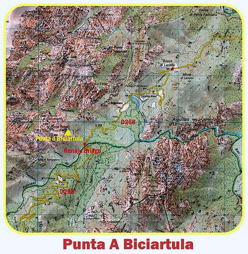
Road access from Col de Bavella to Punta A Biciartula
The buttress is situated along the East side of the road D268 (on the left coming from Col de Bavella), between Renaju Bridge and Polischellu Bridge. From Col de Bavella follow the road D268 down along the Eastern side towards Solenzara for about 10 km., reaching the Renaju Bridge. Park the car 200 m. after Renaju bridge in a pull-out on the left-hand side of the road, near a bend of the ancient road.

|

|

|
Walking approach
From the pull-out a steep trail with several cairns starts, entering into the wood. Exiting the wood, head to left to a shoulder, then scramble up a dry stream, getting the base of the buttress (45 minutes from the pull-out).
Punta A Biciartula routes overview
Punta A Biciartula routes overview from left to right (French Scale):
"Kalliste" - ED inf., 6b/6b+ obbl., 210 m., equipped. Fine route, the most difficult of the buttress
“La Celebration du Lezard” - TD sup., 6b obbl. 220 mt. The name is due to a gigantic monstruous lizard overlooking the upper part of the route. Equipped. Bring 12 expresses and some ribbons
“Alexandra” - TD, 6a+, 6a obbl. 220 m., equipped. It is the most affordable route of the wall. Bring 10 quickdraws, some little friends and some ribbons

|

|
Alexandra report

Alexandra report (French Scale)
Summit altitude: about 970 m
TD, 6a+, 6a obbl.
Length: 220 m.
Exposure: SE
First ascent: P. Clarac - J.L. Fenouil – R. Lamontellerie and E. Neville 2000
Approach starting: Road D268 Col de Bavella between Renaju Bridge and Polischellu Bridge
Huts: Gite d’Etape “du Col de Bavella”, Gite d’Etape “Les Aiguilles de Bavella”
A jewel showing pure “Bavella” orange granite. The first five pitches are sustained on 6a, 6a+. The starting point is near a characteristic tree below a steep slab sormounted by some enormous orange ”tafoni”.
P1 – After some technical moves along the slab, a final climbing on the superb “tafone” leads to a belay below another huge orange “tafone”.6a+
P2 - Frome the belay head diagonally towards left to climb the left edge of the “tafone”, then a corner and finally some slabs slantways to right. 6a
P3 – Diagonally towards left with technical moves, still diagonally towards a corner. Climb another slab to a stance below another great “tafone”. 6a+
P4 – Climb straightly the “tafone” overhanging the stance, then “a tafoni and slabs’ system” with very pleasant climb. Belay below another “tafone”. 6a.
P5 - A block move to climb the tafone on its left-hand side, then slantways toward right climb some little walls leading to a stance near a tree. 6a+
P6 – Some blocks, then traverse easily towards left reaching some superb “tafoni”. Ribbons
P7 - A peculiar move across the hole in the “tafone”, then some others easy “tafoni” and an ending slab to the summit. 4b.
Descent: one 25 m. abseil along the small NW face – on the opposite side to the ascent route. Reach a little saddle. Scramble down the rocky and vegetated East gully, to the second abseil equipped belay. 30 mt. abseil. The third 15 mt. abseil down some block leads to the bottom of the gully situated on the right-hand side – facing out – of the cliff.
")
|

|
Nature and climate
On Bavella Massif nature is wild and peculiar; in Corsica we can find more than 5% of authoctonous kinds of flower and plants, in addition to authoctonous fauna. On the contrary, several kinds of animal current inside Mediterranean countries are away from Corsica, like squirrels and vipers.

|

|

|
Climate is the typical one of the mediterranean middle-mountain areas situated at these latitudes: often very hot in summer and with cold and snowy winters; early and middle Spring and early Fall are the better seasons to climb. Due to Bavella closeness to the sea, winds are often stronger how much they are at the same height in the Alps. Rainfall sometimes are important and dangerous when joined with strong winds. On the contrary, sometimes we can find some long periods of drought.
Red Tape
Bavella is really a fantastic world, a preserved milieu situated inside a Regional Park. Free camping and bivouac are not allowed. Fires are strictly forbidden. Maximum care is required to keep for the future this extraordinary environment.
When to climb
Due to its limited height and its SE exposition, the cliff may be very hot in summer. Best seasons to climb Punta A Biciartula are Spring and Fall.
Where to stay
COL DE BAVELLA
- Auberge du Col de Bavella – Hotel and Gite d’Etape AUBERGE DU COL DE BAVELLA
- Les Aiguilles de Bavella – Gite d’Etape GITE D'ETAPE LES AIGUILLES DE BAVELLA
ZONZA
- Hotel L’Aiglon, Hotel de la Terrasse - Municipal Camping of Zonza, Camping La Riviere (Zonza)
Meteo
Guidebooks and maps

Guidebooks
“Bavedda – Aiguilles entre ciel et torrents: Escalade, Rando, Canyon” by Jean Louis Fenouil and Jean Paul Quilici - FFME
“Rocca é Sole” Massif de Bavedda by Jean Paul Quilici and Francis Thibaudeau
“Corse paradis de l’escalade” by Martial Lacroix
Maps
IGN 4253 ET “Aiguilles de Bavella – Solenzara”