
|
|
Canyon |
|---|---|
|
|
37.30310°N / 112.9324°W |
|
|
Canyoneering |
|
|
Spring, Summer, Fall |
|
|
Overview
I have been told that Mystery Canyon was historically named because the bottom is blocked by a falls and the middle section too, so before canyoneers or climbers descended the canyon, it was a "mystery" as to what was in the canyon. This is a beautiful canyon, but in my opinion has been over developed with climbing anchors, many of them fairly new.Even though many of the technical challenges have been tamed down, don’t get the wrong idea that this canyon is for the inexperienced. It would be foolhardy for anyone to try and descend Mystery Canyon without the proper skills. There have already been several parties rescued from the canyon-don’t be another one.
This canyon is highly recommended for those that have the proper skills needed, but whom are not ready for some of the more challenging canyons elsewhere in Zion or on the Colorado Plateau. At a minimum every member of the group should be well versed in rope skills used by rock climbers and especially in rappelling.
Mystery canyon had its first descent several decades ago. At least one place, rebar is pounded into a hole for an anchor attesting to the creativity or frugality of early canyoneers. The canyon now sees many parties in the May through October season.
Even with all the permanent anchors and development in the canyon, it is still a beautiful route. Highlights include a short but interesting narrows, high walls, greenery, and the last section with several waterfalls and pools. The last section is the best part of the canyon.
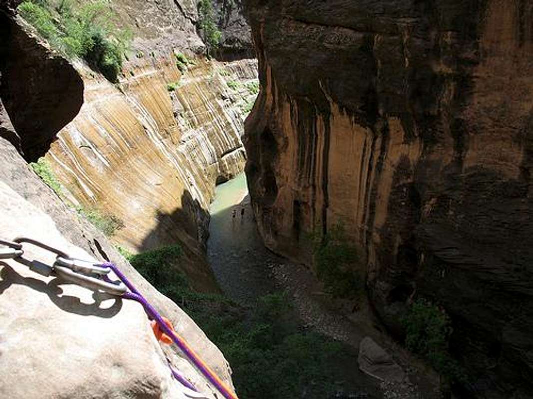
Last pitch in Mystery Canyon. The Zion Narrows is below. The rock is wet and slippery, so you have to be careful not to slip and embarrass yourself in front of all the gawking tourist and their cameras and camcoders. Try to look cool.
Getting There
Hurray for the shuttle bus system. This makes access very easy.Weeping Rock Trailhead
Because you must ride the shuttle bus system in the only season that is practical to descend Mystery Canyon, detailed directions are not needed. From the Springdale or the Zion Visitor Center (or any other shuttle stop in Zion Canyon), simply take the shuttle bus to Weeping Rock. The hike to the head of the canyon begins here.
Temple of Sinawava
You will exit at the Temple of Sinawava Trailhead. This is the easiest trailhead to find in the world because it is at the end of the line for the shuttle bus. You can’t go wrong.
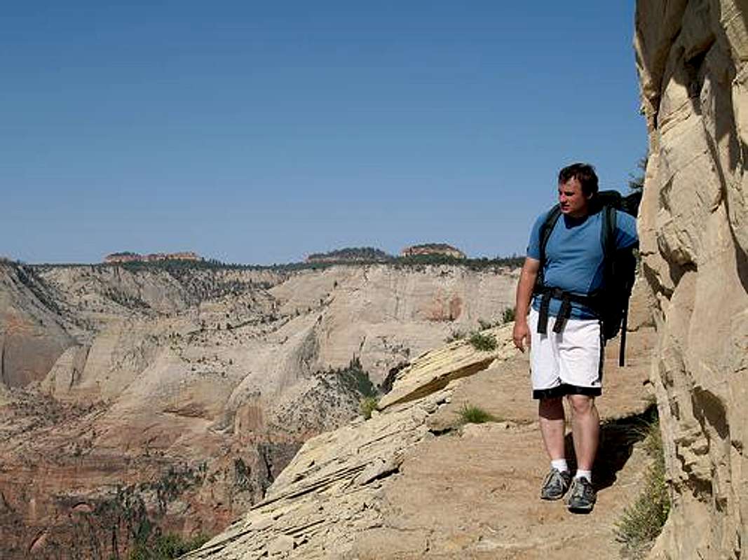
This was taken right below Observation Point on the route to Mystery Canyon.
Routes Overview

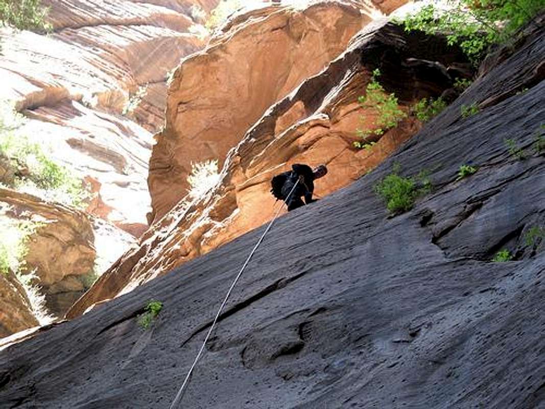
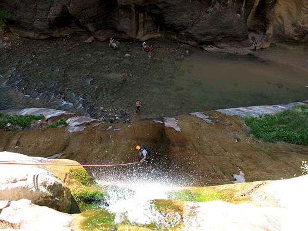
rapping into Mystery Springs2
Approach to the head of the canyon
There are at least two approaches to the head of the canyon.
The recommended route is the trail from Weeping Rock, past Observation Point, and along the East Mesa Trail to the head of the canyon. This is the only practical route, requires no car shuttle, and is the most scenic option.
An alternate route is from the East Mesa Trailhead. This route requires much less elevation gain, but requires a long car shuttle (the shuttle bus does not go to the East Mesa Trailhead), and is less scenic. This route is not recommended. Only the laziest of all canyoneers will consider doing this route to save a few thousand feet elevation gain. If you try this route, shame on you!
Whichever route is chosen, make sure you are at the head of the right canyon before descending. Although I don’t understand why, several parties have gotten lost and ended up in the wrong canyon needing rescue. With a map in hand, the canyon is easy to find.
Descent Route
There is only one descent route. Follow the canyon to the North Fork Virgin River. Once in the canyon there are no navigational difficulties. After a long start through the “Death Gully”, there are several downclimbs and rappels before reaching the river. Most sources give the number of rappels at between 11-13, but many drops are downclimbable. We did the route in five raps, but a belay is in order for several of the downclimbs. Do whatever is safe for your own party and make sure to check all anchors.
See the ROUTE PAGE for details on the route.
Echo Canyon and Mystery Canyon combo
Since both canyons share the same trailheads and part of the access route, you can do both Echo and Mystery Canyons together in one day. If you are feeling stong and have a full day, this is the recommended option to take. See the Echo Canyon page.
Coming down the wall at Mystery Springs.
Clean Canyoneering Ethics
In my own opinion, consider this to be a sacrificial canyon and a good example of what wilderness canyons should never become. What could be a more interesting route has been bolted to the point that some of the challenges have been lost and many of the obstacles can be downclimbed. Since this is a popular canyon, the bolted stations in the canyons should remain, but if you bolt, please only replace existing anchors in the canyon.Red Tape
Permits are required to descend Mystery Canyon. Due to the extreme popularity of the canyon, it would be wise to get a permit in advance. Below is the site to get advanced reservations:Advanced ReservationsAdvanced Reservations
Here are the regulations from the National Park Service:
Reservations are available for Mystery Canyon. They are also available for a wide variety of additional areas. Reservations can be made up to 3 months prior to your trip date.
A reservation is different from a permit. You will need to go into the Zion Canyon or the Kolob Canyon Visitor Center the day before or the day of your trip to pick up your permit and check the most current weather conditions.
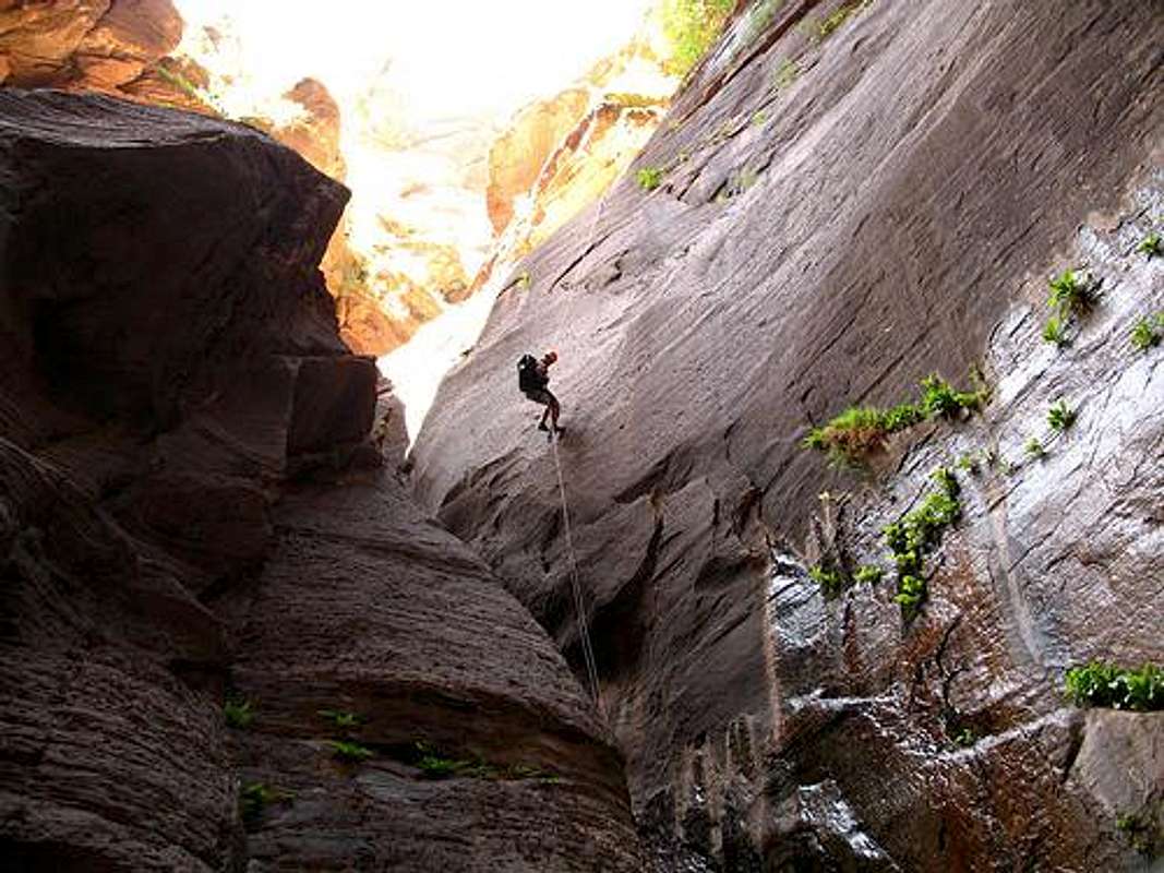
The rap into Mystery Springs in Mystery Canyon. Permits are required for all technical canyons in Zion National Park.
Camping
Although there is camping available on the East Mesa Trail, it is recommended you do the trip as a day trip only. Most parties take anywhere from 6-10 hours.Seasons
May through mid-October is the normal canyoneering season for Mystery. May, September, and early October are the most pleasant seasons to go. June through August can be very hot (though cool once you hit the water) and with the water in the canyon, late October through April can be quite cold. Winter descents are not recommended.Flash floods are a danger in this canyon, especially mid-July through September. Make sure to check current weather forecast at the visitor center backcountry desk.
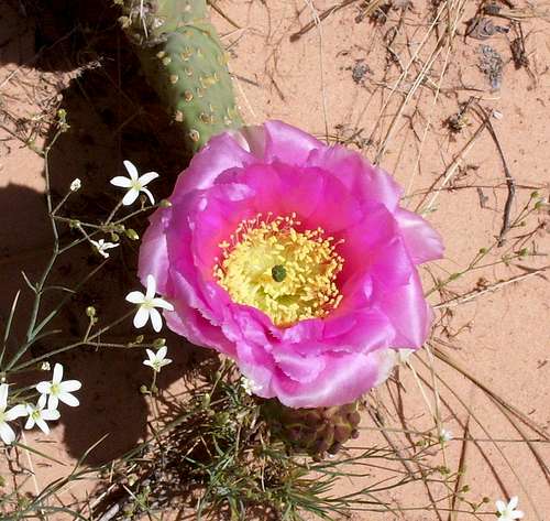
In May, the Prickly Pear Cactus are in full bloom
In Late April, early May, or October a wetsuit is recommended. You probably don’t need to bother mid-May through September unless it is unusually cold or wet. In mid May 2007, we had only a few pools up to waist deep in relatively warm water, but this is not always the case. Usually, or at least in the past, Mystery Canyon is known to have several pools to swim. Check at the backcountry desk for current conditions.
Prepare to get wet.
Canyon Conditions
Weather Forecast for Zion Canyon:CLICK HERE
Weather and climate data for the Zion Canyon, elevation 4050 feet. *National Weather Service Data 1918-2007.
Keep in mind that at the head of the canyon, it will be cooler. In the lower end of the canyon, all the water around makes hot weather pleasant. The middle sections of the canyon can be quite hot.
| MONTH | AVE HIGH | AVE LOW | REC HIGH | REC LOW | AVE PRECIP (in) |
| JAN | 52 | 29 | 73 | -15 | 1.67 |
| FEB | 57 | 33 | 81 | -4 | 1.84 |
| MAR | 64 | 37 | 91 | 10 | 1.91 |
| APR | 73 | 44 | 95 | 21 | 1.17 |
| MAY | 83 | 52 | 106 | 22 | .79 |
| JUN | 94 | 61 | 114 | 35 | .47 |
| JUL | 100 | 69 | 115 | 45 | .99 |
| AUG | 97 | 67 | 112 | 50 | 1.42 |
| SEP | 90 | 60 | 110 | 33 | 1.06 |
| OCT | 78 | 49 | 99 | 17 | 1.07 |
| NOV | 63 | 37 | 85 | 0 | 1.23 |
| DEC | 53 | 30 | 75 | -5 | 1.34 |