

-
 10282 Hits
-
 83.1% Score
-
 16 Votes
|
|
Mountain/Rock |
|---|---|
|
|
45.71241°N / 10.67189°E |
|
|
Hiking |
|
|
Spring, Summer, Fall, Winter |
|
|
4196 ft / 1279 m |
|
|
Overview
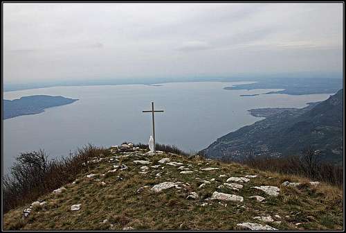 The view from Cima Comer on the southern part of Lago di Garda
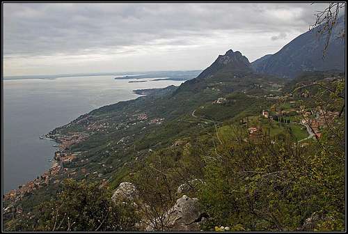
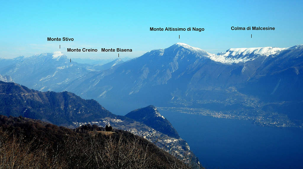
Above the northwestern shore of Lago di Garda there are quite many summits with excellent panorama. Well, you will say with 1279 m it must be a poor hill only, but the fact is that Lago di Garda lake level is only at 100 m and also that all those mountains are falling towards the lake with very steep slopes, some of them even with sheer, almost vertical cliffs. In the middle part of the lake such a summit is Cima Comer. It is very popular and if with anything, it excells with a great view on the southern part of the lake and also on the strong chain of Monte Baldo across the lake. The view towards the north-east is also very fine, we see a great part of the upper Garda lake, and interesting is also the view on the neighbouring summits which are mostly higher, so they mostly obscure more distant views towards the west and north. The summit is very popular with hikers. I have no information if in its cliffs there are any attractive climbs, and it is also possible that some people would enjoy to fly from the summit with a paraglide. As the whole area around Lago di Garda is great for biking and mountain biking, also Cima Comer could be included in a bike tour, but the last 45 minutes of ascent must be done on foot.
Getting There
 Gargnano
You may want to start the tour already on the lake shore, but the majority of visitors come on top either from Sasso village or from Rifugio Alpini. The latter tour is really short. The most recommendable tour is a round trip of some 4 hours which includes also a visit of very picturesque hermitage od San Valentino. That tour is recommended in all guidebooks dealing with the Garda lake area. Sasso, 546 m, is a nicely situated village on a sunny terrace above Gargnano. We drive some 8 km by a good road (very popular with bikers) up from the lake, the village is less than 1 km right of the main road. The parking place is in the beginning of the village. If you'd really decide to drive even up to Rifugio Alpini, you must continue by the main road further up and deter right on some 750 m, above the village of Formaga. The road, which above ends in Briano, brings you just below the hut where you park on 990 m. That's the trailhead for Cima Comer and also for the neighbouring Monte Denervo, 1459 m.
The Hermitage of San Valentino
 San Valentino
Some 30 minutes above Sasso in sheer vertical cliffs, good 700 m high, there is the hermitage which was built in 17th century as a refuge from plague. The small church was built as a votive offering and is today well renewed. Its picturesque position below an overhang and cute architecture make the visit of this pearl a real must.
Red Tape
No special limitations.
Routes On Cima Comer
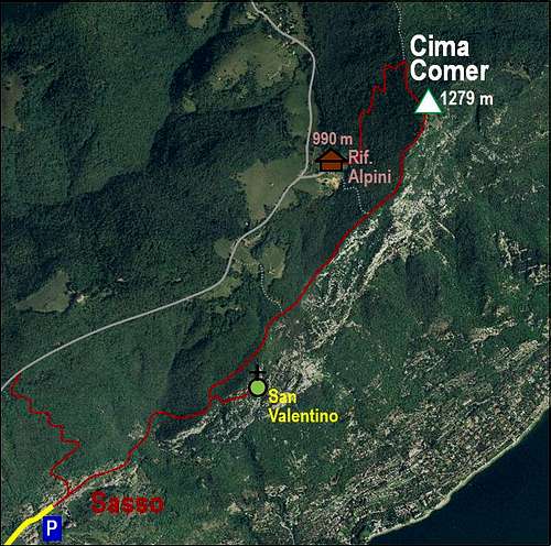
1. Cima Comer from Sasso, 546 m.
This is an overall easy, on many places panoramic ascent. It goes mostly through the woods, but close enough to the open ridge edge, from which we can enjoy views on the lake. On some places the path is narrow, on the upper part also quite weak, but it is nowhere too exposed and orientation is easy - allways by the ridge edge up (marks No. 31 and No. 38). Also the visit of San Valentino goes by some very exposed ledges, but they are broad enough and the path is well beaten. The overall difficulty of the whole round tour on the SAC scale would be T2, 4 h. The ascent only can be done in 1 h 30 min, but taking into account also the visit of San Valentino, it's really some more that 2 h.
 On the way up to Cima Comer
 Along the ridge
Route description. From the parking place we continue through Sasso, and then from the end of the road by a well beaten mule track across the slopes. We gain altitude slowly, do some distance, then cross a creek and then ascend more considerably. Nice views back on the plateau and Monte Castello di Gaino open. After some 20 min of ascent we find ourselves on a small shoulder, where to the right the path to San Valentino branches. We take it, it soon descends sharp right, down through a ravine. So we lose some 30 m of altitude, but then the path takes a broad, but exposed ledge and leads us horizontally into the walls. At the end it ascends again. We reach a small wooden door guarding the access, on the other side we ascend over a short rocky ridge and reach a broader horizontal ledge where the church is placed below an overhang. Some 10 min from the crossroads. To continue the tour on Cima Comer we return to the crossroads and cotinue right through the woods. On one place the path is a bit ruined (2012), there's even a short cable to help, but overall the path is easy and comfortable. It ascends the side ridge, where we turn left and continue ascending. On top of the next ridge step a path offers us an exit to the left, but we continue by the ridge, which again gets panoramic. By a hunters post on the ridge there's another exit path to the left, it supposedly brings us to Rif. Alpini. But we continue in the vicinity of the main ridge. The path gets weaker and steeper, but without any difficulties we reach the baldy summit of Cima Comer. From Sasso good 1 h 30 min, 30 additional minutes for San Valentino visit.
2. From Rif. Alpini, 990 m.
From the mountain hut we follow the marks into the woods, a good path goes in the NE direction. In many turns it leads us up the forrested slopes. Soon we reach the place below the forrested saddle between Monte Denervo on the left and Cima Comer on the right. The first summit can be also reached by a path, but we go right and in a few minutes reach Cima Comer. Les than 45 min from the hut. If we came up from Sasso by the path #1, then we best descend to Rif. Alpini, go from there left by the road until we do enough distance to find ourselves above Sasso. There the marked path deters from the road left down. It is broad, but covered with rough rubble. Through the woods we are soon down in the village. No need to advise, but the best return option is to prepare in advice bikes at Rif. Alpini!
Mountain Huts
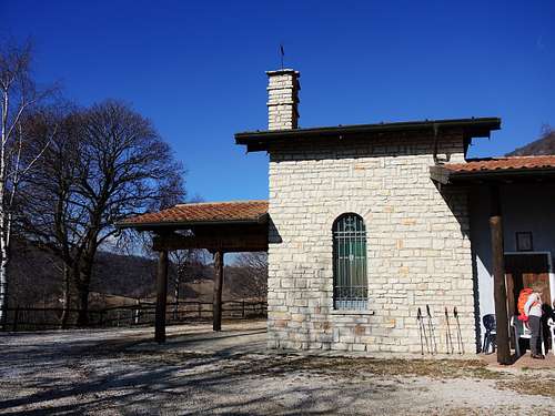
Rif. Alpini, 990 m. It is private, opened only in weekends. Not needed for the ascent itself.
When To Ascend?
On Cima Comer we can go any time of the year.