
-
 5245 Hits
-
 77.48% Score
-
 8 Votes
|
|
Mountain/Rock |
|---|---|
|
|
45.77090°N / 10.08572°E |
|
|
Download GPX » View Route on Map |
|
|
Hiking, Trad Climbing |
|
|
Spring, Summer, Fall, Winter |
|
|
4081 ft / 1244 m |
|
|
Overview
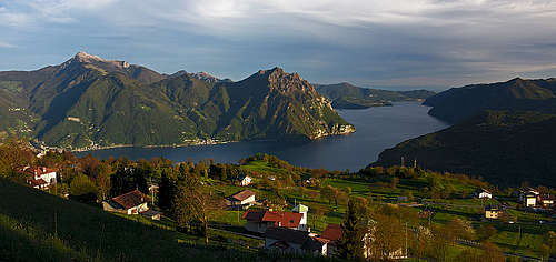
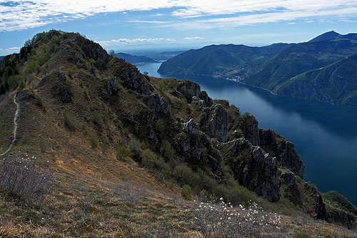
In the close surroundings of Lake Iseo, Corna Trentapassi is the main mountain. You may say that 1244 m of altitude doesn't make an important mountain, but the lake shore is only 200 m above sea level, so due to its magnificent panorama and nice routes Corna Trentapassi is very popular. Some routes, also quite difficult ones, ascend on top from the shore of the lake, others from higher trailheads on the other side.
Corna Trentapassi is a mountain for hikers. One of the long routes is a medium difficult ferrata, requiring also some easy free climbing. I guess the crags above the lake shore are also appropriate for technical and free climbing. Due to dirt roads, reaching high, the mountain is visited also by bikers. We saw them only riding down (but also walking along their bikes), due to steep and rugged summit trails they for sure carry bikes on the summit on shoulders.
Piramidi di Zone
In the broader area, a nice hike is also the round tour through the Piramidi di Zone Natural Reserve. Earth pyramids are really fascinating there!
The Name
The name of our mountain is another example of ridiculous italianization of local toponymes. The original name is Trè Tapàs, which means Three Spikes or Three Thorns. Its three sharp summits are indeed clearly distinguished from many viewpoints around the Lake Iseo.
Geology
Corna Trantapassi is predominantly made of Upper Triassic crystalline dolomites of neritic and carbonate platform, only on the southern part of its broad massif there are also limestones and marly limestones.
Geography
Show a bigger map
The OpenTopoMap above is accurately showing the situation, close-up to see the trails on Corna Trentapassi!
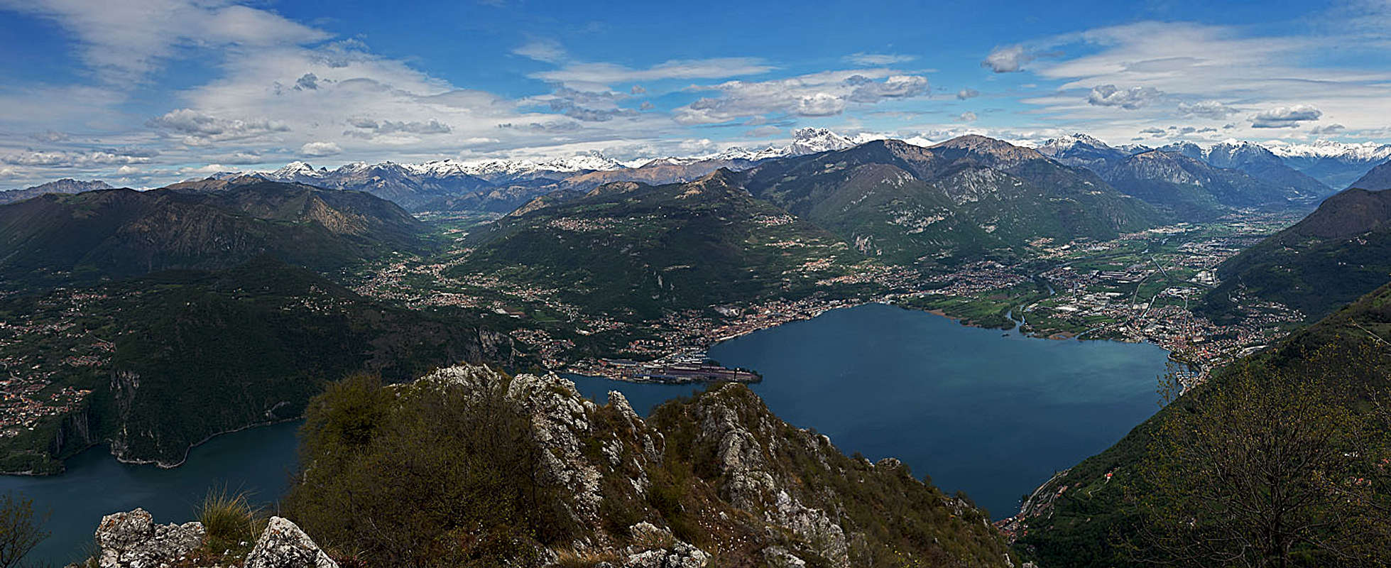
On the main summits many mountain ridges are meeting. The sharpest one is the north ridge, coming up from near the village of Toline. In this ridge there's the Northern Foresummit (Anticima Nord), 1175 m. From the south and in upper regins southwest another strong ridge comes up from the hamlet of Vello. The other two main ridges are coming up from the east and from the south-southeast, meeting on the Eastern Foresummit (Anticima Est), 1192 m. The eastern ridge comes up from Passo Croce di Zone, 903 m, waving over a few ridge bumps. The southern and in upper regions southeastern ridge is the strongest of all. It starts just above the town of Marone on the lake shore, the first summit in it is Anticima Punta Cunicolo, 768 m. Then the sharp Punta Cunicolo comes, 1034 m, and beyond Forcellino del Gadöl, 925 m, the second most important summit in the group, Monte Vignole, 1070 m. From there, the ridge continues northwards on the equally high Dosso Tondo, 1070 m, and in a long arc a bit down on Forcellino del Zuf, 1050 m. From there a broader shoulder ascend towards the NW on Anticima Est.
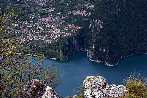
On the lake shore, the towns around Corna Trentapassi are: Pisogne and Toline on the north and Marone and Vello on the south. They are all connected by a most beautiful biking track, dedicated also to hikers and runners. The asphalted line goes through a picturesque rocky scenery just above the lake shore, the main moto road goes a bit higher, all the time underground. The distance is some 11 km. Southeast of the Corna Trentapassi summit is the cauldron of Zone, a nice plateau surrounded with mountains.
Panorama
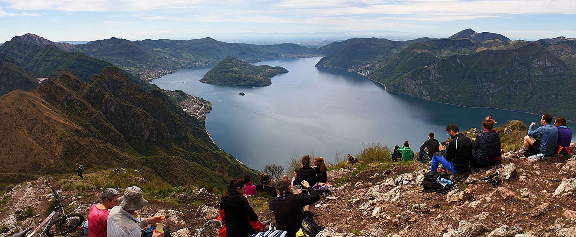
The summit of Corna Trentapassi is one of the best panoramic points above Lake Iseo. The most beautiful view is along the lake towards the south, but great is also the northern view, on the upper part of the lake, along Val Camonica and on the highest mountains of Orobie and Adamello groups. Towards the east, the broad Monte Guglielmo is occupying a big part of the horizon, while on the west many summits of Pre-Alps are being nicely seen.
Equally great as distant views are also the views down on the Lake Iseo, especially on the vertical rock slabs of Bogn, on the western lake shore.
Getting There
The towns and villages on Lake Iseo shore can be reached by the main road, running along the eastern shore. Bus, train and ship connections are rare, so be sure to make a sound itinerary in advance. When we walked from Toline to Marone along the lake shore (end of April), the only option to return was - hitch hiking!
On the other side, there are the following trailheads in the area of Zone:
- Cislano, 580 m. To visit the Natural Reserve of Zone earth pyramids.
- Cusato, 660 m, a part of Zone village. For the normal ascents on Corna Trentapassi and Monte Vignole.
- Passo Croce di Zone, 903 m. For the eastern ascent on Corna Trentapassi.
The Routes
All difficulty grades are on the Swiss Hiking Scale.
1. The round tour through the Piramidi di Zone Natural Reserve is described on a separate SP page. Difficulty T2, 1 hour.
2. SE route via Monte Vignole
This route can be nicely combined with the Normal SE ascent into a round tour (in any direction).
From Cusato, 660 m, we start walking towards Corna Trentapassi, but already at the last houses we turn left and follow the marks across the creek. Soon the path takes the SW direction, crosses the slopes of Monte Vignole, and then in a few long turns ascends Forcellino del Gadöl. There we turn right and start ascending steeply along the main ridge. This is the most difficult stretch (T3), requiring some additional care in steep terrain. The last stretch to Monte Vignole is then a bit easier. From Monte Vignoli we clearly see the summit of Corna Trentapassi, but the ridge till there will still take us another 1 hour. Over a gentle saddle we first ascend Dosso Tondo, then we continue by the main ridge on Forcellino del Zuf, where from the right the normal ascent route joins. In many switchbacks we then continue towards the Eastern foresummit. It can be also detoured by the southern side and then only the last 60 m of summit ascent are awaiting us. Difficulty altogether is T3, 2 h 15 min.
3. Normal SE route

This route can be nicely combined with the SE route via Monte Vignole into a round tour (in any direction).
From Cusato, 660 m, we start walking towards Corna Trentapassi, all the time staying on the right side of the creek (looking up). Good asphalted path brings us in 35 min to Cascina Coloreto alpine meadow, 900 m. There we turn left and following the marks in some 15 min reach Forcellino del Zuf, 1050 m. There we turn right and in many switchbacks continue towards the Eastern Foresummit. It can be also detoured by the southern side and then only the last 60 m of summit ascent are awaiting us. Difficulty altogether is T2, 1 h 30 min.
4. East route. I guess Passo Croce di Zone, 903 m, can be reached from the centre of Zone by a narrow road by car. On the saddle a good marked path deters left. Before ascending Anticima Est of Corna Trentapassi, the path crosses two saddles in the eastern ridge. Difficulty altogether must be T2, some 1 h 15 min.
5. Normal route from Toline, 200 m. From the N not only the ferrata climbs on the summit of Corna Trentapassi. More towards the east from Toline also a normal hike up ascends on Forcella Occidentale Trentapassi, 964 m, one of the saddles in the eastern ridge. Then right on the highest point.
6. Northern ferrata. It's a popular climb, requiring some 3 h. Partly a very steep marked trail (No. 212), partly a ferrata, but some sections are not secured and requre easy free climbing up to UIAA degree II. The route crosses the Northern Foresummit.
7. Southern route from Vello, 200 m. From the hamlet a trail ascents first to the small church of Madonnina, there it branches into two variants, the left one being a normal (easier) one. After joining on some 660 m, only one steep trail ascends towards the highest point.

8. Southern route from Vello, 200 m, via Forcellino del Zuf. This trail goes more eastwards of the trail #7 and joins the normal SE ascent on the notch below the Eastern Foresummit.
9. The whole S ridge from Marone, 200 m. It must be a long, also quite demanding ascent, overcoming all the summits of the south ridge. But the trail is all the time there.
When To Ascend?
Corna Trentapassi can be ascended in all seasons, but in winter time conditions should be considered carefully. Due to low altitude deep snow and ice on the ridges are only rarely an issue, but due to some steep ridge sections in hard conditions take the appropriate equipment.