
|
|
Mountain/Rock |
|---|---|
|
|
45.84706°N / 10.80667°E |
|
|
Trentino |
|
|
Hiking, Scrambling |
|
|
Spring, Summer, Fall, Winter |
|
|
4134 ft / 1260 m |
|
|
Overview
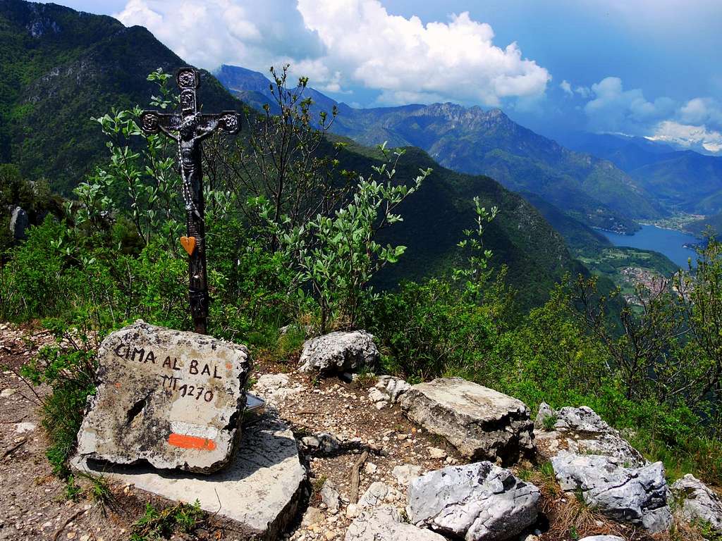
Cima Al Bal 1270 m
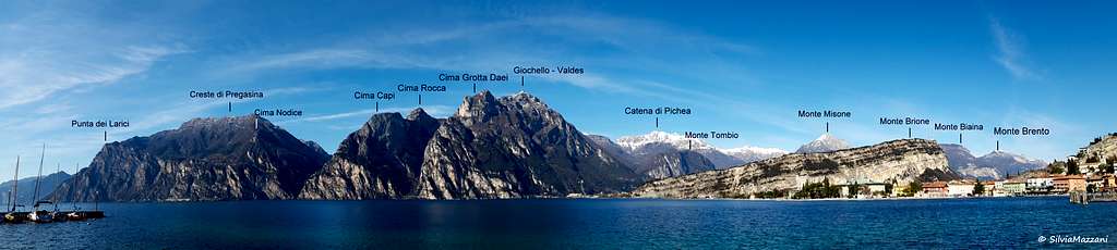
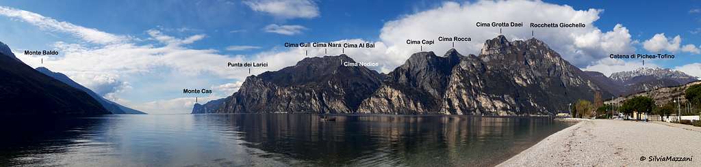
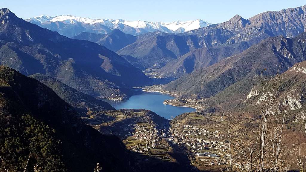
Cima Al Bal 1260 m is a rocky mountain belonging to the Monti del Garda, a subsector of the Prealpi Bresciane and Gardesane. It's located nearby the border between Trentino and Lombardy regions and closely overlying the Western shore of Lago di Garda, which it dominates with exceptional views.
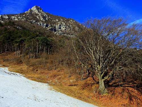
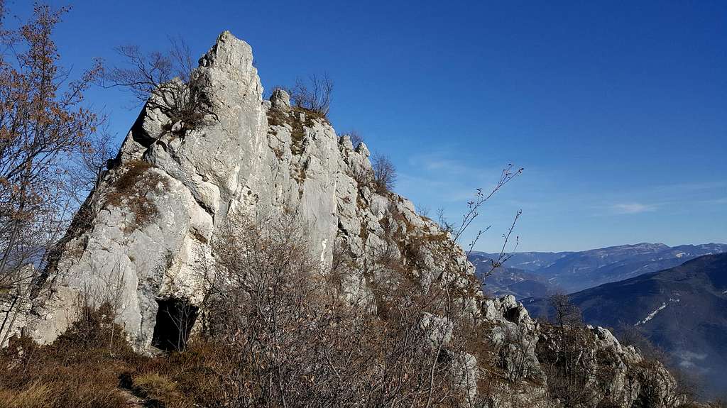
Cima Al Bal is aligned along a ridge formed by different peaks; it's the Northernmost peak climbed by the so-called Pregasina Ridges, a rather long and wild itinerary across an high rocky ridge dominating the Garda Lake and Val di Ledro, with unforgettable views. Cima Al Bal is frequently climbed starting from Pregasina as the first goal along this ridge. The setting is pre-alpine and the route can be climbed during the middle seasons months, or also in winter in the absence of snow on these airy and exposed ridges. Rather hot in summer.he ascent to the summit involves a steep climb and some easy rock steps that don't exceed the I grade UIAA, avoidable through a less direct variation. The ridges, in reason of their strategic location, were involved in the First World War and along the itinerary you will meet countless remains of shelters, trenches, caves and tunnels as well as a small military town. The trail runs through the Italian lines, which faced the nearby Cima Capi, where there were located the Austro Hungarian troups.
Cima Al Bal m. 260 è una montagna dall'aspetto dolomitico appartenente alle Alpi di Ledro, un settore delle Prealpi Bresciane ed è situata vicino al confine tra le due regioni del Trentino e della Lombardia, sovrastando la sponda occidentale del Lago di Garda, che domina con panorami eccezionali. Cima Al Bal è allineata lungo una cresta formata da diverse sommità; è la prima vetta a Nord e viene scalata per prima dalle cosiddette Creste di Pregasina, un itinerario piuttosto lungo e selvaggio attraverso un alto crinale roccioso che domina il Lago di Garda e la Val di Ledro, con scorci indimenticabili. Cima Al Bal viene spesso scalata partendo da Pregasina come primo traguardo lungo questa cresta. L'ambiente è pre-alpino e il percorso può essere effettuato durante i mesi primaverili e autunnali o anche in inverno in assenza di neve su queste creste e sposte. In estate a volte può essere molto caldo. L'ascesa alla vetta comporta una salita ripida e alcuni facili passaggi su roccia che non superano il grado I UIAA, evitabili attraverso una variante meno diretta. Le creste, per la loro posizione strategica, furono interessate dalla Prima Guerra Mondiale e lungo l'itinerario si incontrano innumerevoli resti di rifugi, trincee, grotte e gallerie, nonché una piccola cittadella militare. Il sentiero attraversa le linee italiane, che si affacciavano sulla vicina Cima Capi, dove si trovavano le truppe austro-ungariche.
Getting There
Access: from the Brennero autoroute exit Rovereto Sud and take the road to Arco and Riva del Garda. From Riva del Garda follow the road to Val di Ledro, which is reached through two long tunnels. About 300 meters after the exit of the secondtunnel, you find on the left the narrow but paved road leading to the village of Pregasina 532 m. Leave the car in the small parking lot below the church.


Route: Cima Al Bal from Pregasina
Cima Al Bal from Pregasina via Cima Nodice and Passo Lè
Summit quote: 1260 m
Difficulty: EE
Difference in level: 750 m from Pregasina
Exposition: North, East, West
Time required: 4 hours to Cima Al Bal up and down reversing the same route, 6 hours round trip
Starting point: Pregasina m 522

The route starts from the church of St. George in Pregasina 532 m, a hamlet of Riva del Garda, following the track towards Cima Nodice. From the parking lot up to the road above near the church and turn left near a wooden signpost, walking on a small road to an obvious crossroad indicated by a signpost. We leave on the left the main itinerary and turn to the right steeply uphill on a narrow concrete road. After a very steep first stretch we continue up a more moderate slope to the fork indicated by a signpost in locality Tof m 660. To the left it directs the path n. 422 towards Passo della Rocchetta, we maintain the right hand, following the path n. 429. When we get to a third fork, we leave on the left the path n. 429 to Bocca di Lè and turn right onto the path n. 429A, following the signpost to the Scala Santa and Cima Nodice.


After a narrow rocky passage under a singular spire called "Popo de Lè", the trail passes close to the remains of some military constructions of the WWI. Here it begins the beautiful section called "Scala Santa", a series of steps carved into the rock provided by an iron cable, that allows to overcome this rocky stretch by an easy walk. After the rocky steps we reach a point where it starts a good warpath well marked by red-white signs. This path entirely surrounds the summit of Cima Nodice and runs through trenches and caves carved into the rock. Here at first we ignore this path to get the summit of Nodice in 2 minutes, following a brief not well worn track leading to the remains of the summit military observatory. We briefly return to the military ring surrounding the summit, we walk along it following the red-white marks and we descend on the other side and after reaching the Cemetery of the Alpines we get directly Bocca di Lè 806 m.

|

|

|

|

|

|
Here turn to right on path 429 that descends to Biacesa and at a new crossroads with the signpost "Cima Al Bal" we take the left path n. 430 starting the long traverse, which touches all the peaks that surround the Pregasina plateau: Cima al Bal (or Cima Nora), Cima Strussia, Cima Nara (or Cima dei Coi - 1376 m), Cima Guil. This part of the route runs through the ridge that joins the tops, with some rock passages to be tackled with the help of hands (short passages of I UIAA degree), and requires surefootedness. Once having climbed Cima Bal we have two options:
. reverse the same route
- alternatively continue Southwards along the Pregasina ridges - The track always follows the ridge along one of the most spectacular stretches of the route, with several ups and downs. In front of us we can already see the next peak, Cima Nara, the highest point of the whole crossing. The path 430 bypasses the summit along the Eastern side (towards the Garda Lake). Anyhow, if we don't want to miss the highest point, when we are getting to a small crossroads marked by a wooden stake we must turn sharply to the right, leaving the main trail 430. We climb up some easy rocks, leading to the summit of Cima Nara 1376 m, also called Col Coi, marked by a small signpost.

|

|

|

|

|

|
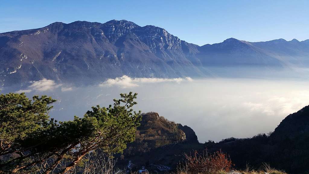
From the summit with some up and down the route joins the path 430 which descends decisively passing on the West side and crossing a beautiful forest, getting to the marked saddle of Passo Chiz. The last climb leads to the summit of Monte Guil (no indication), the last summit. A brief descent gets the beautiful meadow saddle of Prati di Guil. With a sharp left turn, the route takes the path 422 towards Passo Rocchetta, traversing under the Western slopes of Mounte Guil (Garda Lake side), getting the fascinating and characteristic large saddle of Passo Rocchetta. From Passo Rocchetta we can chose amongst three paths, all running to Pregasina: the path 130 Creste di Reamol to the right, a path that goes down right away in the middle and another path on the left. We follow the middle trail, running down inside the forest to reach the wonderful glade of Malga Palaer. From the shelter we proceed along the forest road to the right, following the signs to Bocca Larici. Once reaching Bocca Larici 881 m we continue westwards (to the right) towards the promontory of Punta Larici and, after passing through the settlement of Malga Larici, we reach the summit of Punta Larici, excellent panoramic point over the entire Garda Lake. From Punta Larici we take the crests trail, in the first section traversing with breathtaking view over the lake, then, after a steep descent, joining the forest road. Following this latter rightward we come back to Pregasina.
Italian version
Il percorso parte dalla chiesa di San Giorgio in Pregasina 532 m, frazione di Riva del Garda, seguendo la traccia verso Cima Nodice. Dal parcheggio si sale alla chiesa e si svolta a sinistra vicino alle tabelle segnaleetiche, camminando su una piccola strada fino a un evidente bivio indicato da un cartello. Lasciamo a sinistra l'itinerario principale e giriamo a destra in salita su una stretta strada di cemento. Dopo un primo tratto molto ripido proseguiamo su una pendenza più moderata fino al bivio indicato da un cartello in località Tof m 660. A sinistra il sentiero n. 422 verso il Passo della Rocchetta, manteniamo invece la destra seguendo il sentiero n. 429. Arrivati a un terzo bivio, lasciamo a sinistra il sentiero n. 429 per Bocca di Lè e svoltiamo a destra sul sentiero n. 429A, seguendo le indicazioni per Scala Santa e Cima Nodice. Dopo uno stretto passaggio roccioso sotto una guglia singolare chiamata "Popo de Lè", il sentiero passa vicino ai resti di alcune costruzioni militari della Prima guerra mondiale. Qui inizia la bellissima sezione chiamata "Scala Santa", una serie di gradini scavati nella roccia forniti di un cavo metallico, che permette di superare facilmente questo tratto. Dopo i gradini rocciosi raggiungiamo un punto in cui inizia un buon sentiero di guerra ben segnalato dai segni bianco-rossi. Questo percorso circonda interamente la cima di Cima Nodice e attraversa trincee e caverne scavate nella roccia. In un primo momento ignoriamo questo percorso per raggiungere la vetta di Cima Nodice in due minuti, seguendo una breve traccia che porta ai resti dell'osservatorio militare della cima. Ritorniamo brevemente all'anello militare che circonda la vetta, camminiamo lungo di esso seguendo i segni bianco-rossi e scendiamo dall'altro lato. Dopo aver raggiunto il Cimitero degli Alpini prendiamo in direzione di Bocca di Lè 806 m. Qui si gira a destra sul sentiero 429 che scende a Biacesa e ad un nuovo bivio con il cartello "Cima Al Bal" prendiamo il sentiero a sinistra n. 430. Inizia qui la lunga traversata che tocca tutte le vette che circondano l'altopiano di Pregasina: Cima al Bal (o Cima Nora), Cima Strussia, Cima Nara (o Cima dei Coi - 1376 m), Cima Guil. Questa parte del percorso attraversa la cresta che unisce le cime, con alcuni passaggi di roccia da affrontare con l'aiuto delle mani (brevi passaggi del grado IIAA), e richiede passo sicuro.
Una volta saliti su Cima Al Bal ci sono due possibilità:
- ritornare per lo stesso itinerario
- proseguire verso sud lungo le creste di Pregasina. L'itinerario segue sempre la cresta lungo uno dei tratti più spettacolari del percorso, con diversi saliscendi. Davanti a noi possiamo già vedere la prossima vetta, Cima Nara, il punto più alto dell'intera traversata. Il sentiero 430 scavalca la vetta lungo il versante orientale (verso il lago di Garda). Se non vogliamo perderci il punto più alto, arrivati a un piccolo incrocio segnato da un paletto di legno dobbiamo girare nettamente a destra, lasciando il sentiero principale 430. Risaliamo alcune rocce facili, che conducono alla sommità di Cima Nara 1376 m, chiamata anche Col Coi, segnata da un piccolo cartello. Dalla cima con un alcuni saliscendi il percorso si riunisce al sentiero 430 che scende decisamente passando sul versante Ovest e attraversando un bel bosco, arrivando alla sella di Passo Chiz. L'ultima salita porta alla cima del Monte Guil (nessuna indicazione), l'ultima cima. Una breve discesa porta alla bella sella dei Prati di Guil. Con una brusca virata a sinistra, il percorso imbocca il sentiero 422 verso il Passo Rocchetta, attraversando sotto le pendici occidentali di Mounte Guil (lato Lago di Garda), raggiungendo l'affascinante e caratteristica ampia sella del Passo Rocchetta. Dal Passo Rocchetta possiamo scegliere tra tre sentieri, tutti in direzione Pregasina: l'aereo sentiero 130 delle Creste di Reamol a destra, un sentiero che scende subito nel mezzo e un altro sentiero a sinistra. Seguiamo la via di mezzo, scendendo nella foresta per raggiungere la meravigliosa radura di Malga Palaer. Dal rifugio procediamo lungo la strada forestale sulla destra, seguendo le indicazioni per Bocca Larici. Giunti a Bocca Larici 881 m proseguiamo verso ovest (sulla destra) verso il promontorio di Punta Larici e, dopo aver attraversato Malga Larici, raggiungiamo la vetta di Punta Larici, eccellente punto panoramico su tutto il lago di Garda. Da Punta Larici prendiamo il sentiero delle creste, nella prima sezione attraversando con vista mozzafiato sul lago, poi, dopo una ripida discesa, raggiungiamo la strada forestale. Seguendo quest'ultimo verso destra torniamo a Pregasina.
Red Tape
No permits, no fees required.
Hiking and scrambling grades of difficulty
VERSIONE INGLESE
T - Turistico (Tourist): Itineraries on wide, clear and well worn paths, sometimes on mule tracks or gravel roads. The routes are never exposed, don't give any orientation problems and don't exceed 2500 meters of altitude. Suitable also for children.
E - Escursionisti (Hikers): Itineraries on marked trails, even narrow and with possible steep and impervious sections. They are never exposed and don't give any orientation problems. They can tread different kinds of ground, such as forests, gravel, meadows, pastures, easy rocks, etc.). They form the majority of the trails that wind up in the mountains and require a certain habit to walk; you need equipment suitable for the altitude and resistant footwear with soles suitable for rough terrain.
EE - Escursionisti Esperti (Experienced Hikers): Itineraries for hikers with experience and good knowledge of the mountain. Some of these paths may have exposed sections, however brief, which require firm foot and no dizziness. They require the ability to adapt to particular terrain, such as steep grassy slopes or stretches of rocks with difficulties that can reach the 1st degree of the UIAA scale. They can also reach high altitudes (3000 m or more). Sometimes they may include unmarked sections, requiring a good sense of orientation. Snow slopes are possible, however which can be overcome without specific mountaineering gear (rope, harness, crampons, ice-axe).
EEA - Escursionisti Esperti con Attrezzatura (Experienced Hikers with equipment - The same as EE, in addition these routes require the use of via ferrata equipment (lanyards, harness, carabiners, heat sink, helmet). This kind of itineraries range from the trails with short easy and not much exposed sections, previously equipped with fixed ropes and iron pegs, to the true and more difficult Via Ferratas climbing on rocky walls or on aerial ridges and ledges, previously equipped with long stretches of iron ropes, iron steps, ladders without which proceeding would constitute a real climbing. It is necessary to know how to use the technical equipment and have a certain habit of exposure and mountaineering terrains.
VERSIONE ITALIANA
T - Turistico: itinerari su sentieri ampi, evidenti e ben tracciati, a volte su mulattiere o strade sterrate. I percorsi non sono mai esposti, non danno problemi di orientamento e non superano i 2500 metri di altitudine. Adatti anche ai bambini
E - Escursionisti: itinerari su sentieri segnalati, anche stretti e con possibili tratti ripidi e impervi. Non sono mai esposti e non danno problemi di orientamento. Possono percorrere diversi tipi di terreno, come foreste, ghiaioni, prati, pascoli, facili rocce, ecc.). Costituiscono la maggior parte dei sentieri che si possono incontrare in montagna e richiedono una certa abitudine a camminare. Richiedono inoltre un equipaggiamento adatto all'altitudine e calzature resistenti con suole idoneee ai terreni accidentati
EE - Escursionisti Esperti: itinerari per escursionisti con esperienza e buona conoscenza della montagna. Alcuni di questi percorsi possono presentare sezioni esposte, per quanto brevi, che richiedono piede fermo e assenza di vertigini. Richiedono la capacità di adattarsi a terreni particolari, come ripidi pendii erbosi o tratti rocciosi con difficoltà che possono raggiungere il I grado della scala UIAA. Possono anche raggiungere quote elevate (3000 m o più). A volte possono prevedere tratti non segnalati, che richiedono un buon senso dell'orientamento. Sono possibili pendii nevosi, che possono essere superati senza attrezzatura specifica per l'alpinismo (come corda, imbragatura, ramponi, piccozza)
EEA - Escursionisti Esperti con Attrezzatura - Come l'EE, in più questi percorsi richiedono l'uso di attrezzatura da via ferrata (cordini, imbragatura, moschettoni, dissipatore di calore, casco). Questo tipo di itinerari spazia dai sentieri con brevi tratti facili e poco esposti, dotati di corde fisse e/o pioli di ferro, verso le vere e più difficili Vie Ferrate che affrontano pareti rocciose o creste aeree, dotate di lunghi tratti di corde fisse generalmente in acciaio, gradini di ferro e/o scale senza cui la progressione diventerebbe una vera e propria scalata. È necessario essere a conoscenza delle modalità di utilizzo dell'attrezzatura tecnica e avere una certa abitudine all'esposizione e ai terreni alpinistici.
When to Climb
Best seasons are Spring and Autumn. Summer months may be very hot. In wintertime only in absence of snow and ice.
Accomodation
Different possibilities of accomodation in Riva del Garda, Val di Ledro and Pregasina
Bibliography
"Prealpi Bresciane" by Fausto Camerini - Collana Guide dei Monti d'Italia, CAI-TCI
Maps:
KOMPASS sheeet 071 – Alpi di Ledro Valli Giudicarie 1:50.000
LAGIRALPINA sheet 016 - Alpi di Ledro - Tremalzo 1:25.000
Meteo Forecast
Meteo Trentino
Meteo arpalombardia