
|
|
Mountain/Rock |
|---|---|
|
|
45.94518°N / 10.76985°E |
|
|
Trentino |
|
|
Hiking, Scrambling |
|
|
Spring, Summer, Fall |
|
|
7044 ft / 2147 m |
|
|
Overview
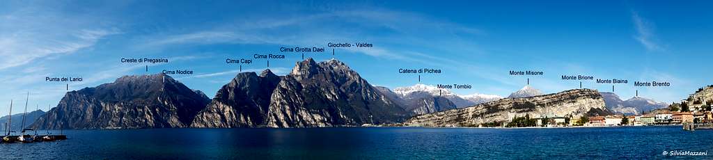
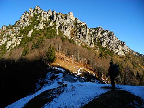
Cima di Pichéa m. 2147
Cima di Pichéa m. 2147, belonging to the Alpi di Ledro, a subsector of the Prealpi Bresciane e Gardesane is a mountain lined up on the long ridge situated between Lago di Garda and the Giudicarie and joining the two saddles of Bocca di Trat and Bocca dell'Ussol. This ridge is traveled by a portion of the Sentiero della Pace (Peace Trail, n. 455). More precisely Cima di Pichéa lies between the Mazza di Pichéa 1879 m, a rocky summit dominating the Bocca di Trat, and Monte Tofino 2151 m. Cima di Pichéa is inaccurately called by some people as Corni di Pichéa. This habit can cause confusion in recognizing the peaks. In fact, the Corni di Pichéa are a set of rocky spiers located along the ridge between the first rocky point, called Mazza di Pichéa, and the real Cima Pichéa.
The ascent to the Cima di Pichéa can be performed in conjunction with the neighboring Mazza di Pichea or alternatively as one of the summits on the long crossing between Bocca di Trat and Bocca dell'Ussol. Another option is to climb only Cima di Pichéa as a goal itself. These peaks, like many others in the Alps of Ledro, have been a theater of the World War I since they were very close to the Austro-Hungarian border with Italy. Still today, walking on the highest ridges, it's easy to observe what remains of the war-trenches and caves.
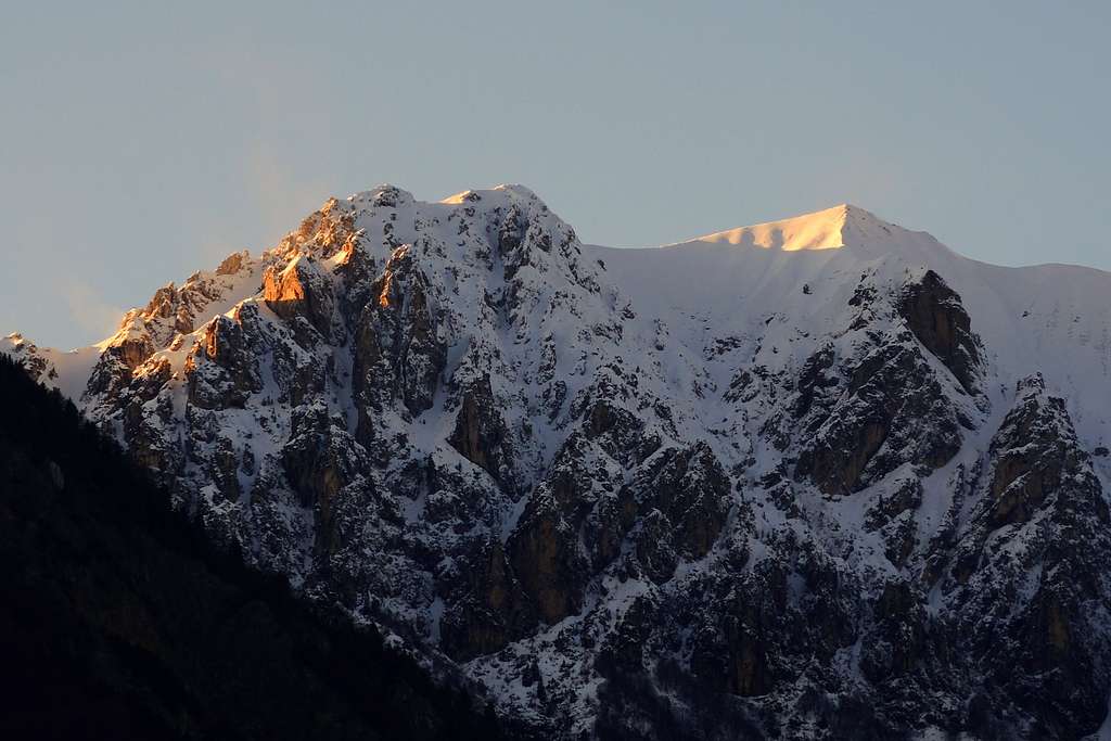
The view offered are really huge: from Lago di Garda to Tre Cime Bondone (to the NE), Monte Stivo and Monte Baldo (to the East), Monte Misone, Paganella and Brenta Dolomites (to the North), Presanella, Adamello and Carè Alto (to the West) and the neighboring Alpi di Ledro.

Cima di Pichéa 2147 m, appartenente alle Alpi di Ledro, un sottogruppo delle Prealpi Bresciane e Gardesane, è una montagna allineata sulla lunga costiera situata tra il Lago di Garda e le Giudicarie e che congiunge le due selle di Bocca di Trat e Bocca dell'Ussol. Questa costiera è percorsa da un ramo occidentale del Sentiero della Pace, che collega il Passo del Tonale al Lago di Garda. Più precisamente Cima di Pichéa si trova tra la Mazza di Pichéa 1879 m, vetta rocciosa che domina la Bocca di Trat, e il Monte Tofino 2151 m. Cima di Pichéa è da alcuni erroneamente chiamata Corni di Pichéa. Questa abitudine può creare confusione nel riconoscere le cime. I Corni di Pichéa sono infatti un insieme di guglie rocciose situate lungo il crinale tra la prima prominenza rocciosa, denominata Mazza di Pichéa, e la vera Cima di Pichéa.
La salita alla Cima di Pichéa può essere effettuata in concomitanza con quella alla vicina Mazza di Pichea, o in alternativa come una delle vette della lunga traversata tra Bocca di Trat e Bocca dell'Ussol. Un'altra opzione è scalare solo la Cima di Pichéa come meta a sè stante. Queste vette, come tante altre delle Alpi Ledro, furono teatro della Prima Guerra Mondiale, in quanto molto vicine al confine tra Austria e Italia. Ancora oggi, camminando sui crinali più alti, è facile osservare ciò che resta delle trincee e delle caverne di guerra.
I panorami offerti sono davvero vasti: dal Lago di Garda alle Tre Cime Bondone (verso NE), Monte Stivo e Monte Baldo (verso Est), Monte Misone, Paganella e Dolomiti di Brenta (verso Nord), Presanella, Adamello e Carè Alto (verso Ovest) e le vicine Alpi di Ledro.
Getting There

The starting point to climb the mountain is Bocca di Trat m. 1587.
Access to Malga Trat: from the Brennero autoroute exit Rovereto Sud and take the road to Riva del Garda. From here follow the road to Val di Ledro, pass the tunnel, entering the valley and skirting the Lago di Ledro. Reach Pieve di Ledro, located at the end of the lake, where you must leave the main road and turn to right to Val Concei, getting to the small village of Lenzumo. At the end of Lenzumo turn to right again (signposts Rif. Nino Pernici), taking a 7 km. mountain road which rises with several hairpins to Malga Trat m. 1502 (about 50 km from Rovereto). The road is closed in its last 500 meters, so leave your car in an obvious pull-out on the right side of the road. An alternative way to reach Bocca di Trat is starting from Malga Grassi m. 1056, which can be approached by car from the settlement of Campi, above Riva del Garda. This second possibility involves a significant increase in the level difference.
Access to Malga Grassi: from the Brennero autoroute exit Rovereto Sud and take the road to Riva del Garda. From here follow the road to Tenno, then Pranzo and Campi. In Campi take the gravel road to Malga Grassi. At the end of the road leave the car in the parking lot.
Il punto di partenza per salire la montagna è la Bocca di Trat 1587 m.
Accesso a Malga Trat: dall'autostrada del Brennero uscire a Rovereto Sud e prendere la strada per Riva del Garda. Da qui si segue la strada per la Val di Ledro, si supera la doppia galleria, si entra nella valle e si costeggia il Lago di Ledro. Raggiungere Pieve di Ledro, situata all'estremità Ovest del lago, dove bisogna lasciare la strada principale e svoltare a destra per la Val Concei, arrivando al piccolo paese di Lenzumo. In fondo a Lenzumo svoltare ancora a destra (indicazioni Rif. Nino Pernici), percorrendo 7 km. di strada di montagna che sale con diversi tornanti a Malga Trat 1502 m (circa 50 km da Rovereto). La strada è chiusa negli ultimi 500 metri, quindi si lascia l'auto in un evidente spiazzo sul lato destro della strada. Un modo alternativo per raggiungere Bocca di Trat è partire da Malga Grassi 1056 m, raggiungibile in auto dall'abitato di Campi, sopra Riva del Garda. Questa seconda possibilità comporta un aumento significativo del dislivello da superare.
Accesso a Malga Grassi: dall'autostrada del Brennero uscire a Rovereto Sud e prendere la strada per Riva del Garda. Da qui si segue la strada per Tenno, poi Pranzo e Campi. A Campi si prende la strada sterrata per Malga Grassi. Alla fine della strada lasciare l'auto nel parcheggio.
Route: Cima di Pichéa from Bocca di Trat
Cima di Pichéa from Bocca di Trat
Difficulty: EE
Difference in level: 500 m from the road to Malga Trat

Route description
- From the parking lot at the altitude of 1440 m follow the gravel road leading to Malga Trat 1502 m. Take the path 413 rising inside the wood and getting to the large saddle of Bocca di Trat m. 1581. From the saddle three short diversions from our itinerary to the Cima di Pichea are possible, all worthy. On the right and just a few steps from the saddle there is the Rifugio Nino Pernici 1601 m.

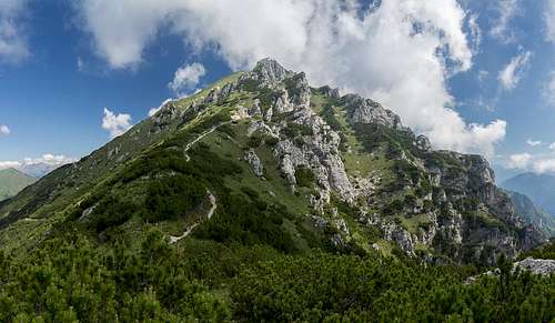
It's lying in a fine location with good views to the rocky summit of Mazza di Pichea and Lago di Garda and can be reached with a short deviation to the right from our itinerary. When we come back to the Bocca di Trat we take on the left the path n. 420 named "Sentiero della Pace", rising and skirting the South-West side of Mazza di Pichea. Another brief but absolutely deserving digression leads to the WWI Cave "Ludwig Riccabona" (see the next point). Returned on the main path soon we reach another junction. In fact above and rightward we find a short trail, it's another short digression leading to the rocky summit of Mazza di Pichéa 1879 m. The climb involves a brief scramble aided with fixed ropes. If you decide to do the short but worth deviation, after getting the summit of Mazza di Pichéa, downclimb to reach again the junction and take again rightward the main path n. 420. The route continues among the pastures following at first a mainly flat track that crosses the meadows. Then we go up to gain an important shoulder. There are some easy rocky passages to overcome, skirting a rocky band. On easier ground we gain the ridge of Cima di Pichea and then, again with a short not marked deviation from the main path 420, the summit of Cima di Pichéa (cairn) which can be reached without difficulty following the remains of a trench dating back to the First World War. We are now in sight of the top of the Tofino: a large saddle divides the Cima di Pichèa from this summit.

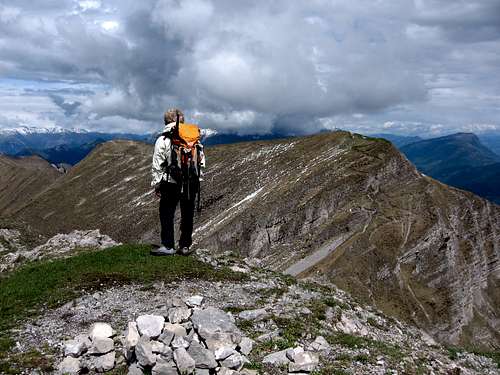
Descent: reversing the same route
Route: Corno di Pichéa from Malga Grassi
Cima di Pichéa from Malga Grassi
Difficulty: EE
Difference in level: 500 m from the parking lot near Malga Grassi
From the parking lot follow for a short distance a concrete road and then turn left following the SAT trail number 402. Return to the road for a stretch and then return again to the SAT 402 trail. Go up into the woods until you reach the former Malga Dos dei Fiori. From this point follow the dirt road uphill until you reach Bocca di Trat where the itinerary joins the previous one from Malga Trat. See the description in the previous chapter.
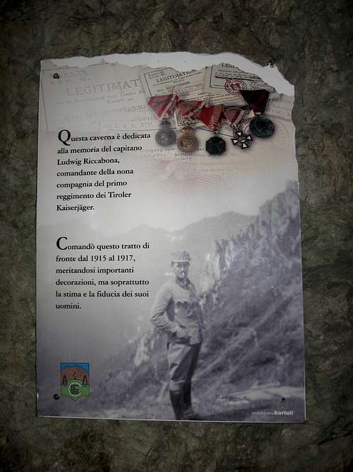
WWI - The Cave "Ludwig Riccabona"
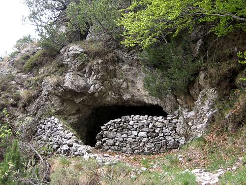
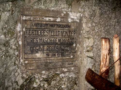
From the Bocca di Trat it begins, well signposted, the path n. 420 that climbs diagonally to the North-West, sometimes in the woods. In this stretch we border, well marked by the signposts, an old cave used during the First World War as a refuge, that can be reached with a short and worthy detour. It's the Ludwig Riccabona cave. During the First World War the position under the Mazza di Pichea was used by the lookouts of the Austro-Hungarian army to monitor the Val Concei. On the Bocca di Trat, considered strategic, there was in fact an important logistic center of the Austro-Hungarian army. Here it fought a company of the Tyrolean Kaiserjagers under the command of the Captain Ludwig Riccabona. Near the cave it has been recently built a copy of the Captain's war hut. Ludwig Riccabona, to whose memory the gallery is dedicated, was commander of the Kaiserjäger corps stationed in Valle di Ledro.
Red Tape

No fees no permits required. Cars are not allowed in the last 1 km on the road to Malga Trat.
When to Climb
The best period goes from May to November
Hiking grades of difficulty
T - Turistico (Tourist): Itineraries on wide, clear and well worn paths, sometimes on mule tracks or gravel roads. The routes are never exposed, don't give any orientation problems and don't exceed 2500 meters of altitude. Suitable also for children
E - Escursionisti (Hikers): Itineraries on marked trails, even narrow and with possible steep and impervious sections. They are never exposed and don't give any orientation problems. They can tread different kinds of ground, such as forests, gravel, meadows, pastures, easy rocks, etc.). They form the majority of the trails that wind up in the mountains and require a certain habit to walk; you need equipment suitable for the altitude and resistant footwear with soles suitable for rough terrain
EE - Escursionisti Esperti (Experienced Hikers): Itineraries for hikers with experience and good knowledge of the mountain. Some of these paths may have exposed sections, however brief, which require firm foot and no dizziness. They require the ability to adapt to particular terrain, such as steep grassy slopes or stretches of rocks with difficulties that can reach the 1st degree of the UIAA scale. They can also reach high altitudes (3000 m or more). Sometimes they may include unmarked sections, requiring a good sense of orientation. Snow slopes are possible, however which can be overcome without specific mountaineering gear (rope, harness, crampons, ice-axe)
EEA - Escursionisti Esperti con Attrezzatura (Experienced Hikers with equipment - The same as EE, in addition these routes require the use of via ferrata equipment (lanyards, harness, carabiners, heat sink, helmet). This kind of itineraries range from the trails with short easy and not much exposed sections, previously equipped with fixed ropes and iron pegs, to the true and more difficult Via Ferratas climbing on rocky walls or on aerial ridges and ledges, previously equipped with long stretches of iron ropes, iron steps, ladders without which proceeding would constitute a real climbing. It is necessary to know how to use the technical equipment and have a certain habit of exposure and mountaineering terrains.
Accomodation

Different possibilities of accomodation in Val di Ledro Along the route we find the Rifugio Nino Pernici 1601 m
Bibliography

"Prealpi Bresciane" by Fausto Camerini - Collana Guide dei Monti d'Italia, CAI-TCI