
|
|
Mountain/Rock |
|---|---|
|
|
46.43738°N / 13.51593°E |
|
|
Hiking, Mountaineering, Ice Climbing, Big Wall, Mixed, Scrambling, Via Ferrata, Skiing |
|
|
Spring, Summer, Fall, Winter |
|
|
8209 ft / 2502 m |
|
|
Overview
 Beljaski stolp / Campanile di Villaco, 2247m and climbers on the summit.
Cime Castrein / Kostrunove spice, 2502m is the mountain located in the Vis group and it is the neighbour of mighty Vis, 2666m. It is located between two notches. On the west side is the notch Forcella Lavinal dell Orso / Skrbina sprednje Spranje, 2138m where starts alos the Montaz group. The notch on the east side is Forc. Mose, 2271m. Both notches are very popular Winter goals with some nice couloirs. The summit of the Kostrunove spice is rarely visited in the comparison with Vis. Just below the summit, crossing the south ridge, goes the ferrata Anita Goitan. It goes just some 10 meters below the main summit. You reach the main summit from the ferrata over the old military paths. On the summit is the real treasury of the rests of the First World war. Many bunkers, paths and some other stuff are visible here.
 Beljaska igla (Ago di Villaco, 2050m).
To the both notches fall the steep grassy and somewhere also rocky slopes. Over both slopes, west and east, goes the ferrata Anita Goitan. The north side is much more impressive. Over 800 meters high face falls down to the end of the valley Zajezera / Saissera. Some hard climbing routes go there. To the south side also falls down the south face, to the slopes above the hut Rif. Corsi, 1874m and down to the meadow Malga Grantagar / Viseva planina, 1530m. Here are two big towers. One (the lower one) is called Beljaska igla (Ago di Villaco, 2050m). The higher one is called Beljaski stolp (Campanile di Villaco, 2247m). Both are approachable only with climbing. The normal approach is very airy climbing route with the difficulty UIAA III. But there is many nice climbing routes directly above the Rif. Corsi (hut). Check the route overview section.
Kostrunove spice is primarily climbers and hikers mountain. Because its upper part is steep also on the west and east side it is not appropriate for tour skiing. Still, some lower lying slopes and couloirs offer in spring very nice skiing opportunities.
The view from the summit of Kostrunove spice is amazing. Specially the view on mighty Vis that is directly above us. You can see the whole Montaz group and also the whole Julian Alps. In good visibility you see also the giants of Hohe Tauern group in Austria.
Getting There
The approach valley to the Western Julian Alps will probably be the highway through Val Canale (Udine - Tarvisio). But of course it doesn't reach the heart of this mountain group.
The map of the area.
For the south ascent you must deter from the highway in Chiusaforte and travel through Rakolana (Reklanica, Raccolana) valley to Sella Nevea (Nevejsko sedlo) pass, 1142 m. Then over the pass and down to the altitude around 1000 meters where the macadam road starts. A bit upper is a big parking place. This point can also be reached from Tarvisio towards south through Valle Rio di Lago (Jezerska dolina).
For the north ascent you deter from the highway some seven kilometers west of Tarvisio and drive south into the Valbruna (Zajzera) valley. The road ends on an alpine meadow on the altitude of 1000 m.
Tarvisio and Valle Rio di Lago (Jezerska dolina) can also be reached from east, from Slovenia (from the Sava valley or over the Predel (Predil) pass and of course also from north, from Austria (from Villach).
For some tourist information see the Tarvisio tourist page.
Maps:
- Tobacco Map 019 - 1:25000 - Alpi Giulie Occidentali Tarvisiano.
- Julijske Alpe - Zahodni del (Western part). Planinska zveza Slovenije. 1:50000.
Route Overview
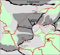 A map of the area - marked routes.
 Marked routes
1. From the Rif. Corsi (hut), 1874m over the notch Forc. Mose, 2271m. It start by the Rif. Corsi, 1874m and goes over the south slopes of Vis, 2666m all the way to the notch Forc. Mose, 2271m. Then over the east slopes you reach the south ridge. From the notch you follow the ferrata Anita Goitan. And then over the south ridge over the old military paths to the summit. Description.
2. From the valley Zajezera / Saissera over Forcella Lavinal dell Orso / Skrbina sprednje Spranje (notch), 2138m. This route goes from the north side to the notch and then also over the west part of ferrata Anita Goitan to the south ridge and then over the military paths to the summit. Description.
3. From the valley Valle Rio di Lago (Jezerska dolina) over Forcella Lavinal dell Orso / Skrbina sprednje Spranje (notch), 2138m. This route goes from the south side to the notch and then also over the west part of ferrata Anita Goitan to the south ridge and then over the military paths to the summit. Description.
 Beljaski stolp (Campanile di Villaco, 2247m). Climbing routes
1. Normal approach on Beljaska igla (Ago di Villaco, 2050m). Airy climbing with difficulty UIAA III.
2. Normal approach on Beljaski stolp (Campanile di Villaco, 2247m). Airy climbing with difficulty UIAA II-III.
3. South ridge of Beljaska igla (Ago di Villaco, 2050m). UIAA IV+/III-IV.
 Montaz, 2754m seen from the notch Sprednja spranja / Lavinal dell'Orso in Winter. Winter routes and ski routes
1. Ski route from the south side to the notch Forcella Lavinal dell Orso / Skrbina sprednje Spranje, 2138m. It starts on the meadow Malga Grantagar / Viseva planina, 1530m and then goes over the grassy slopes to the notch.
2. Ski route from the north side to the notch Forcella Lavinal dell Orso / Skrbina sprednje Spranje, 2138m. It starts in the valley Zajezera / Saissera and goes through the whole valley all the way up to the notch. The last 50 meters are steep.
3. Mojzes`s couloir directly to the notch Forc. Mose, 2271m from the north side. 45°. Skiing estimation is III. This route is popular only in Winter season when the couloir is full of snow.
4. Kiss or kill. V/5, M6, 600m, 8 hours. 85°-90°/70°. First climbed by Luca Vuerich and Michelle Martina. Climbing route, popular in Winter season.
5. Kis ali vino. V/M5+, 600m, 5 hours. 90°+/30°- 90°. First climbed by Mirko Kranjc and Marko Prezelj. Climbing route in Winter season. Here is the photo of the route.
There is also possible skiing from the summit down the south (or SW) slopes and face, but that it is an alpinistic ski tour.
For more information about climbing routes just send me private message.
Red Tape
No limitations or special permits.When To Climb
The best and the easiest time is in the snowless season. That is in Summer and Autumn. But also in Winter there are some nice routes for climbing. But be careful because of avalanches and the loneliness of north face. In snow season there is very popular to ski down the north slopes and face through some nice couloirs.Camping
 Rif. Corsi, 1874m below the south face.
Some huts and bivouacs.
On south,east side:
- Refiugio Guido Corsi (hut), 1874m
On north:
- Rif. Attillio Grego (parking place 400 m below it in Valbruna or on Sella di Somdogna, 1398m, 15 minutes away), 1395 m.
- Bivacco D. Mazzeni (bivouac), 1630m, below the north nad west face on big slopes.
Then a lot of camping places you can find in the valleys around Vis and Montaz group.