
-
 5648 Hits
-
 84.27% Score
-
 18 Votes
|
|
Mountain/Rock |
|---|---|
|
|
46.41282°N / 13.48509°E |
|
|
Hiking, Mountaineering, Scrambling, Via Ferrata, Skiing |
|
|
Spring, Summer, Fall, Winter |
|
|
7713 ft / 2351 m |
|
|
Overview

The SE slopes

Monte Cregnedul and Punte Plagnis
Intro
What is nowadays called Monte Cregnedul / Vrh Krnega dola is the south-easternmost pillar of Montaž mountain chain. It is a nice hiking goal, which can be reached by an ex military mule track, but also by a side jump from ferrata Ceria Merlone, which crosses the whole chain. The old mule track, you wouldn't believe, is even done by some experts as a mountain bike descent.
A Mess With Names
On an old Italian military map the points 2411 m and 2351 m were by mistake exchanged. So, today the higher peak is "wrongly" called Punta Plagnis / Špice v Planji and the lower one Monte Cregnedul / Vrh Krnega dola. Actually the rocky peak 2411 m is the true peak above Krni dol (ravine), while the three lower elevations south of it are rising directly above the grassy ridge of Planota / Plagnota (which in Slovenian language means a plane, a more flat part of the ridge), so their natural name should be Punte Plagnis. But the mistake was done and it stayed so.
In the text which follows, I will write the majority of names only in Italian (Furlani), even if most of toponymes have also Slovenian and some of them also German names. As we saw, some names, like Cregnedul, have a Slovenian origin only and their current Italian version is nothing more than a written vocal shell.
Geology
It is typical for the central chain of western Julian Alps. The upper part of Monte Cregnedul is built of the Upper Triassic limestone, but the base of the massif is made of crystalline dolomite from the Upper Triassic period. This base can be found on the lower areas on the eastern side of Monte Cregnedul. In the southern areas, however, near Casera Cregnedul di Sopra, the original rocks are covered with much younger, Pleistocene glasial deposits, the same picture as on the whole Altipiano del Montasio.
Character and Geographic Facts

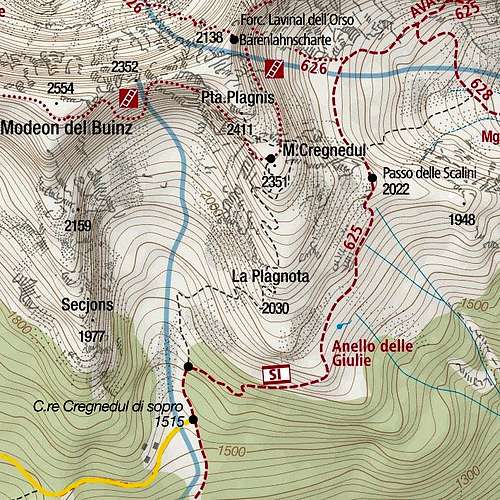
Modeon del Buinz and Punte Plagnis
If we divide the Montaž chain in three parts, the most south-eastern part is a compact crest of high mountains. After reaching the highest points on Foronon del Buinz, 2515 m, and Modeon del Buinz, 2554 m, the crest lowers on Forca de la Val (notch), 2352 m, and then continues on Cime delle Puartate, 2436 m and Punte Plagnis, 2411 m (the "should-be" Monte Cregnedul). Already NE of Cime delle Puartate, there is a deep notch of Lavinal dell'Orso, 2138 m, beyond which the main crest of Julian Alps continues on Viš group. But the Montaž chain continues a bit more towards the SE. After Punte Plagnis it lowers on the important notch below Monte Cregnedul, ca. 2320 m, and then continues on the rocky towers of Monte Cregnedul itself. The highest tower is the one just above the notch, but by most visitors the next elevation is considered as the summit of Monte Cregnedul. Soon after it, the ridge starts lowering considerably. And it also branches immediately. The southern branch is the grassy ridge of La Plagnota / Planota, the E-SE ridge is a similar grassy ridge which first lowers on Passo delli Scalini, 2022 m, and then after the next rocky elevation lowers down in the woods above Sella Nevea. Between these two grassy ridges there are broad, but steep meadows, reaching the very summit rocks of Monte Cregnedul. More rocky and precipituous is of course the NE face, which forms together with the face of Punta Plagnis and Cime delle Puartate a monolythic wall above the valley below Forcella Lavinal dell'Orso. From Cregnedul di Sopra alpine meadow towards the north a broad, but in the upper part also a steep valley goes. It's natural end is on Forca de la Val, 2352 m, on the main crest. In times of tour skiing this valley and the upper ravine offer a quite popular ski tour and also in summer from Forca de la Val you can descend without bigger problems there. From this valley a steep ravine ascends also towards the notch between Punte Plagnis and Monte Cregnedul.
Summit Views
From the summit of Monte Cregnedul we can enjoy great views only towards the east, south and west. Towards the NW Modeon del Buinz is obscuring the view, but it looks great itself. Towards the north, the nearby rock towers of Punta Plangnis are obscuring distant views. The overall scenery is very nice however. In a clear day, great is the view on Mangart and Jalovec, two giants of Julian Alps on the east. On the south the whole chain of Canin/Kanin mountains is stretching, below them we nicely see Sella Nevea and its ski slopes.
 Viš group |
 Towards the east |
 Kanin / Monte Canin |
Getting There
Even if Forcella Lavinal dell'Orso can be also reached from the north, from Saisera, you will most likely use for ascents on Monte Cregnedul trailheads on the southern side. See the main page of Viš and Montaž group how to drive in Saisera, Val Rio del Lago and Val Raccolana! The saddle between the latter two valleys is Sella Nevea. Suitable trailheads are:

Morning biking

Casere Larice
1. Altipiano del Montasio - the big parking place below Pecol meadow, 1502 m. From there it is best to use a mountain bike to reach Casere Cregnedul di Sopra, 1515 m, because the road goes almost 5 km quite horizontally. Bikes are suitable, of course, if you also return to Cregnedul di Sopra.
2. Sella Nevea, 1162 m. From there you have to walk up 1 h to reach Casere Cregnedul di Sopra, 1515 m (but it looks that a direct road goes there as well).
3. Val Rio del Lago - parking place on 1025 m. That is also the trailhead for ascents in Viš group. By a mountain road (closed for public traffic, but still not too steep for a mountain bike) you reach in 1 h 20 min Malga Grantagar, 1530 m.
Ascent Routes
On a separate page, I will describe only the southern mule track, which is the route, specific for Monte Cregnedul. Ferrata Ceria Merlone is already described on a very good page by ganesh70.
1. From Forcella Lavinal dell'Orso by Sentiero attrezzato Ceria-Merlone. If we go there over Cregnedul di Sopra, 1515 m, we need till there some 30 min by bikes from Pecol or on foot 1 h (either from Pecol or from Sella Nevea). Then we continue towards the E around the ridge and then across the SE slopes of Monte Cregnedul on Passo degli Scalini, 2022 m. 1 h 30 min. (This pass has its name since 1890, when on the NE side of it some stone steps were cut.)
 Across the SE slopes |
 Passo degli Scalini |
From Passo degli Scalini we descend 100 m towards the N and then go towards the W on Forcella Lavinal dell'Orso - 45 min. Altogether around 3 h. Approximately the same time you will need to ascend from Val Rio del Lago, 1025 m, to Malga Grantagar and further on the notch.
 Towards Lavinal dell Orso |
 Montaž from Lavinal dell Orso |
From Forcella Lavinal dell'Orso you enter the NE face of Cime delle Puartate. Some first rock passages are not protected, then you use the first ledges and good cables lead you up over steep wall steps. Whereever possible, the route uses good ledges, leading you far towards the left. The path is very picturesque, exposure is great, but protection devices are also very good. Passing the NE edge of Punta Plagnis the path reaches very steep grassy slopes. There the path is narrow and exposed, on a few places not protected (grassy slopes). Finally it reaches slabs which the path overcomes with a ladder. So you reach the notch between Punte Plagnis (right) and Monte Cregnedul (left).
 The N walls of Monte Cregnedul and Punte Plagnis |
 Ferrata Ceria Merlone goes by nice ledges |
 Ceria Merlone |
There you turn left (Ceria Merlone climbs right up) and follow an ex military path around the corner. You pass caverns and then turn left on the nearby summit. 1 h from the Forcella Lavinal dell'Orso. Difficulty of ferrata is C (Austrian grade), or PD, difficulty on the Swiss Hiking Scale is T4.

On the southern slopes
2. Southern mule track. During World War I Italian army was holding positions on Montaž group, while Austro-Hungarian army was holding Viš group. The southern mule track on Monte Cregnedul is slowly decaying, but is still today very comfortable and easy, only in hot summer days it is more recommended for a descent. On the web there are even posts of mountain bikers who ride up the very beginning of it, then they carry bikes on the top and ride down (except the upper 20 meters). The path goes from Cregnedul di Sopra directly up, holding on the slopes of La Plangnota and avoiding the final rocks by the left side. Difficulty of most of the tour is T2, only the final ascent is T3. 2 h 15 min. Descent can be done by the same route or you can continue by ferrata Ceria Merlone to Forca de la Val and then descend directly from that notch towards the south.
3. From Passo degli Scalini. I am not sure if it is not a mistake, but there are reports that also from this notch a direct ex military path goes up by the east ridge, avoiding on top the summit rocks of Monte Cregnedul. If true, that path must be much steeper, more decayed and so more difficult. It is also possible that authors confused the east ridge with the ridge of La Plagnota, where old ex military paths indeed connected trenches and caverns.
Mountain Huts and Bivouacs
Monte Cregnedul ascents can be done in one day, but on those mountains there are many huts surving the purpose of traversing the whole crest of Montaž mountains.
1. Rifugio Alpino "Casere Cregnedul di Sopra", 1515 m. (http://www.caserecregnedul.it/) These nice huts are the best starting point for the ascent on Monte Cregnedul. They can be reached from the big parking place on Altipiano del Montasio (below Pecol) in 1 hour walk or good 30 min bike. The nice, mostly very panoramic road goes almost horizontally across the slopes. From Sella Nevea it is 1 h of walk up by path No. 625.
 Casere Cregnedul di Sopra |
 Casere Cregnedul di Sopra |
 Casere Cregnedul di Sopra |
2. Rifugio Brazza, 1660 m, stands on Altipiano del Montasio. From the big parking place it's 20 minutes of walk up.
3. Malga Grantagar, 1530 m. The hut was renewed in 2004, but I'm not sure if they also offer beds there. 1 h 20 min from Val Rio del Lago.
4. Rifugio Corsi, 1874 m, is the most important base for southern ascents in Viš group, but many people start crossing also Montaž chain from there. The hut is reachable in some 2 h 30 min from Val Rio del Lago.
5. Bivacco Luca Vuerich, 2531 m, stands on the summit of Foronon del Buinz and is used by those who do long crossings of Montaž group.
Red Tape
No limitations. Mountain roads on alpine pastures other than Pecol are closed for public traffic.
When To Climb?
Monte Cregnedul can be climbed vitually any time of a year, only in deep snow and when summit slopes are icy the ascent is not recommended. In winter conditions ice pick and crampons are required. The summit of Monte Cregnedul itself is not a typical ski tour, more popular is the nearby tour on Forca de la Val.