
-
 9439 Hits
-
 85.36% Score
-
 20 Votes
|
|
Mountain/Rock |
|---|---|
|
|
46.47876°N / 13.35967°E |
|
|
Hiking, Mountaineering, Scrambling, Skiing |
|
|
Spring, Summer, Fall, Winter |
|
|
6398 ft / 1950 m |
|
|
Overview

Montaž
Memories on visits of mountains on which you were in fog, are accompanied with a sweet bitterness and a strong wish to come there again. If any, one of such mountain for me is Monte Schenone / Lipnik. I belive its summit offers one of the most beautiful views on Montaž, the king of Western Julian Alps. But on our first visit this monumental peak showed only for a few seconds...
Next time I was there on a ski tour. Alone, too late and without equipment to reach the top. And almost the whole day Montaž was resting in clouds...
Otherwise the views from Monte Schenone / Lipnik are nice in all directions. It does not fly really far in distances, except towards the north and south. From Montaz towards the west the long crest of Monte Cimone / Strma peč stretches. Across Canal del Ferro there is the hard reachable Zuc dal Bor - a whole mini-massif, on which we look from the eastern side. Also the views to Carnic Alps main ridge and towards the central crest of Eastern Alps are very rewarding. A full 360 degree panorama from the top can be found here.
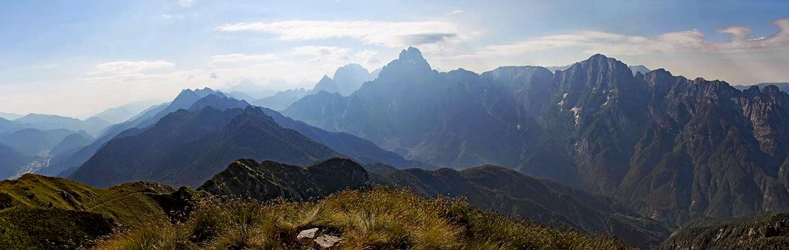
Eastern panorama from Monte Schenone / Lipnik
Geography

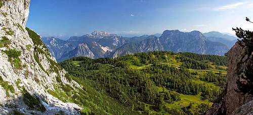
Montaz from Monte Schenone

Monte Schenone / Lipnik from the east
The northern chain of Vis and Montaz group is also named Catena di Malborghetto / Naborjetske gore. They have their name by the town in Val Canale / Kanalska dolina, north of the range. These mountains are quite low in comparaison with Viš or Montaž, but their biggest advantage is a great view on the main part of the group. From nowhere Viš and Montaž look so fine as from Pizzo di Mezzodi / Poldnašnja špica, Due Pizzi / Dve špici, or - from Monte Schenone / Lipnik. The latter is not the last summit on this range. Even more towards the west there is a few meters higher Jôf di Dogna / Dunjski vrh, 1961 m. But due to a nice mountain road Monte Schenone / Lipnik is far more often visited.
So, towards the north there's Val Canale / Kanalska dolina, towards the south there's Dogna/Dunja valley. Below Pontebba, where Val Canale turns towards the south it is named Canal del Ferro / Železna dolina. In a small village in Canal del Ferro, in Pietratagliata, a narrow mountain road ascends over steep slopes towards the east. Over a few alpine meadows it reaches some 1700 m high saddle between Monte Piccolo / V Kapelu, 1748 m and Monte Schenone / Lipnik, 1950 m, and then descends down, on Sella Biéliga, 1479 m, and further down towards the south into Dogna/Dunja valley, thus encircling our mountains. The saddle 1700 m below Monte Piccolo / V Kapelu is also called Za Kuglom / Anhaltersattel.
Actually, the summits of Monte Schenone / Lipnik, 1950 m, and Jôf di Dogna / Dunjski vrh, 1961 m, could also be treated as two peaks of only one mountain, but let us see how posting on SP evolves. In future we might have two pages or only one. The tour from M. Schenone on Jof di Dogna took me almost one hour. In the ridge between the two peaks there are some more rocky elevations, which have the following altitudes (from the NE to SW): 1927 m, 1921 m, 1934 m, 1863 m, 1909 m, 1926 m.
East of Monte Schenone / Lipnik in the main ridge there is Lanež, and after a distinct notch the summit, called Clap del Jovel / Sleme Laneža, 1845 m.
The northern slopes of Monte Schenone are rocky and steep. The southern slopes are steep too, but rocks are intermitted with grass, so more passages are possible. Lower below these slopes end in a hopeless wilderness of Rio Mas and its side ravines, ending finally in Dogna.
Maps: Tabacco, No. 18. 1:25000.
Getting There

Hiking-up from Malga Poccet
The trailheads for Monte Schenone / Lipnik can be reached from the highway Udine - Tarvisio. But you must exit the highway in Pontebba (and drive southwards by the local road).
1. From Pietratagliata village, in Canal del Ferro, you can drive eastwards by a narrow ex military mountain road. It winds up a steep slope, but is during summer good maintained, so you can reach without problems after some 7 km Malga Pocet (meadow), 1325 m. There the road is closed, but a good idea is to drive with a mountain bike up to the saddle below Monte Piccolo.
2. In Dogna village we can deter from the main road and drive into Dogna valley till the village of Chiout, 838 m. There a mountain road deters towards the north, but it is fortunately closed for public traffic. You can again drive up with a bike and reach by the road the saddle below Monte Piccolo. If you go on foot, you can do a shortcut already much below Biéliga meadow and ascend the summit of Monte Schenone / Lipnik by the marked path No. 601.
The meadows north and east of Monte Schenone / Lipnik can also be reached by paths from the north, from Val Canale / Kanalska dolina. The path from Pontebba/Tabelj, 561 m, is also marked (no. 601), and so is the path from Bagni di Lusnizza, 635 m, on Sella Biéliga / Dol.
Routes Overview
Hikes
1. From Malga Poccet.
The shortest ascent comes from the saddle 1700 m, below Monte Piccolo / V Kapelu. But the marked path doesn't go from the highest point of the saddle. A non-marked path is cut through pine bushes and soon you hit the marked path No. 601, coming from the right. If you walk up from Pietratagliata or from Malga Pocet, 1325 m, you leave the road on the first curve above the hut and follow a weak trail (yellow-red marks) towards the east. It brings you on the mountain road again on the section above Ricovero Jeluz. Then you follow the road, but only to the next big turn, where plates direct you right off the road - you continue in the same direction, or a bit towards the SE. This is the path No. 601 (white-red marks). It gains the side ridge above the saddle, then you cross up the eastern slopes of Monte Schenone and soon reach Forcella, 1846 m, a distinct notch on the ridge, which descends from Monte Schenone to Clap del Jovel.
 Gaining the notch on the E ridge.
Now turn sharply rigt and follow a broad ex military path (mulatiera), which ascends just below the main ridge towards the top of Monte Schenone / Lipnik. The broad path crosses steep grassy slopes, then it gains the main ridge, goes just a few meters by the northern side and immediately returns back, on a picturesque, broad enough ledge, which crosses the eastern slopes of the foresummit. Soon after, below the main summit the scene repeats, only that it is crossed not by a ledge, but by grassy slopes. Finally, you gain ruins of barracks just below the summit and on top you have only a few meters. Altogether 1 h 45 min from Malga Pocet and only 1 h from the saddle.
 East ridge |
 Foresummit with the ledge |
 By the nice ledge |

Casera Bieliga
2. From Casera Biéliga.
Coming up by the mountain road from Dogna/Dunja valley, from Chiout, 838 m, you don't need to walk by the road just to Casera Biéliga. On the altitude of 1351 m a marked path (No. 601) deters left from the road and continues straight up through woods. The path goes all the time close to the ridge, above the Biéliga alpine meadow and across the slopes to the saddle before Clap del Jovel, where marked path No. 602 joins from the right (from the east), coming from Sella Biéliga. But we continue by a comfortable military path in the same direction (towards the NW), cross the southern slopes of Clap del Jovel and reach Forcella, the notch behind it. Then as described in #1 to the top.
3. Crossing to Jôf di Dogna / Dunjski vrh, 1961 m.

Jof di Dogna from Monte Schenone
From the summit of Monte Schenone / Lipnik you can continue towards Jôf di Dogna / Dunjski vrh by the main ridge. But it is narrow and exposed and the weak trail soon disappears. If you wish to ascend the twin peak, it is more recommendable to follow the marked path No. 602. In order to do so, descend from Monte Schenone / Lipnik a few minutes back towards the east (by the approach, described in #1). Soon you will find yourself on a crossroads. Over a steep, grassy slope the path no- 602 descends towards the south. Take some care there! You will first lose some 50 meters of altitude, then the path, again from the World War 1, starts crossing towards the right by a distinct, nice grassy ledge. It is generally broad, but some care is still needed. Reaching the pine bush area you lose again some altitude, but then the path starts ascending again and you reach the main ridge. Follow it towards the left. Don't go by the main ridge, but follow the marked path, where it goes over the northern slopes. After an hour you will reach the panoramic Jôf di Dogna / Dunjski vrh. This route, in reverse direction, can be also a possible approach to Monte Schenone / Lipnik if you attempt crossing both peaks, starting below in Dogna/Dunja village, 450 m. At the entry of the valley start pursuing the path no. 602 towards the north. But you will need some 4-5 hours to the top of Jôf di Dogna / Dunjski vrh and another hour to Monte Schenone / Lipnik.
4. From Chiout Zucuin.
On the map there is another possible ascent from Dogna/Dunja valley. A non-marked path starts in Chiout Zucuin, 808 m, and goes directly northwards into Rio Mas ravine. It must have been an old shepherds passage, which high above hits the marked path no. 601.

A biking paradise...

Over alpine meadows
A Mountain Bike Tour
Yes, I have a hot wish for 2007 - to encircle Jof di Dogna / Dunjski vrh and Monte Schenone / Lipnik with a bike and of course ascend the latter by its normal approach too. Some time in autumn, when larches are golden, preferably!
The tour in sections: Pietratagliata, 520 m - (2 h 30 min) - Malga Poccet, 1320 m - (30 min) - Ricovero Jeluz, 1515 m - (30 min) - Saddle below Monte Piccolo / V Kapelu, 1700 m - (1 h) - Monte Schenone / Lipnik, 1950 m - (30 min) - Saddle below Monte Piccolo / V Kapelu, 1700 m - (10 min) - Malga di San Leopoldo / Gorenja Lipaljska planina, 1565 m - (15 min) - via Sella Biéliga / Dol to Casera Biéliga / Velika planina, 1454 m - (45 min) - Chiout, 838 m - (30 min) - Dogna/Dunja, 425 m - (30 min) - Pietratagliata, 520 m. Altogether 1525 m of altitude, some 7 h 15 min to 8 h of biking and walk-up.
My guess would be that it is better to start ascending by bike from Pietratagliata. The road to Malga Poccet will be in shadow in the morning. From there the road ascends to Ricovero Jeluz and further on the 1700 m high saddle below Monte Piccolo / V Kapelu. There one would leave a bike, ascend in an hour Monte Schenone / Lipnik, and come back by the same route. The rest is a bike descent on Malga di San Leopoldo / Gorenja Lipaljska planina, further down on Sella Biéliga / Dol, then by Casera Biéliga / Velika planina and down to Chiout in Dogna/Dunja valley. By the asphalt road down the valley of Dogna/Dunja to the village with the same name and then by the main Canal del Ferro valley towards the north to Pietratagliata.

The view on Montaz

Skiing from Monte Piccolo
A Ski Tour
Monte Piccolo / V Kapelu, 1748 m. This summit above the saddle, where the mountain road reaches its highest point is also a nice goal of a ski tour. It is panoramic, easy, but the majority of the tour goes unfortunately by mountain roads. So, your main goal shoud there really not be skiing, but some walking and enjoying great panoramas. The ski tour can be done in a high winter from Chiout (by the road), and from Malga di San Leopoldo / Gorenja Lipaljska planina by the fine eastern slopes, or I guess also from the other side, from Pietratagliata. In winter 2007 I met there quite some people walking with snow-shoes.
The other goal of tour skiing is Clap del Jovel / Sleme Laneža, 1845 m. You first reach the broad saddle of Sella Biéliga, 1479 m, where you deter westwards, following the summer route No. 602. Through light woods and open terrain it brings you on a undistinct saddle south of the summit, from where you have just a few minutes on top.
Red Tape
No limitations.
Huts And Camping

Demolition in the wood

Ricovero Jeluz
There are no official mountain huts around, but you can get some support on alpine meadows, where home products are being sold. North of Monte Schenone / Lipnik, by the mountain road there is Ricovero Jeluz, 1515 m. It is allways opened and has a bed, table and a stove.
When To Climb?

Don't touch!

Autumn time
Monte Schenone / Lipnik can best be ascended in summer and autumn. In late autumn it doesn't matter if days are short, as we can drive-up with a car till 1325 m. In spring it can be easilly ascended till the saddle 1700 m, but above quite some care is needed when the steep grassy slopes are covered with snow. With an ice pick and if snow is hard with crampons, following the path to the summit should not be too hard also in winter. The neighbouring Monte Piccolo and Clap del Jovel are also easy tour skiing goals.
And remember: to enjoy the best views on Montaž, you should best come on top in late afternoon!