-
 1173 Hits
-
 77.48% Score
-
 8 Votes
|
|
Mountain/Rock |
|---|---|
|
|
46.50282°N / 13.46769°E |
|
|
Hiking |
|
|
Spring, Summer, Fall, Winter |
|
|
3960 ft / 1207 m |
|
|
Introduction
Monte Nebria is a small mountain, but it still offers a nice outing, views around and some insight into the history of Val Canale.
In adition to this popular name, Monte Nebria has also its old Slovenian name: Podgorski vrh.
Overview
| See full screen |
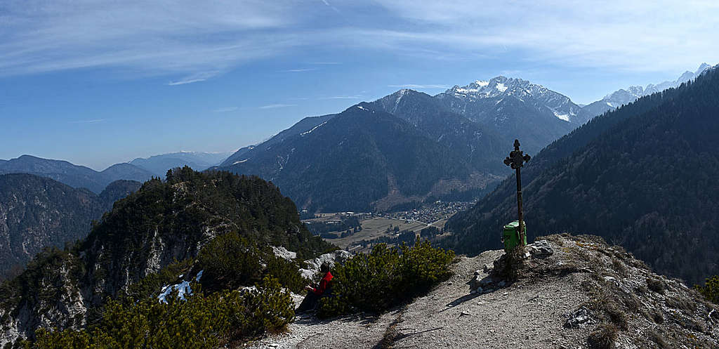
Val Canale / Kanalska dolina lies on a geologic fault and separates the Western Julian Alps from the Carnic Alps main streak (Eastern part). Monte Nebria rises just in the middle of the valley. It's interesting that the Fella / Bela river flows north of it, so geographically Monte Nebria belongs to Julian Alps. But geologically the fault runs south of the mountain, over the Forcella Nebria, so Monte Nebria geologically belongs to Carnic Alps. And indeed, its rocks are similar to those of the mountains on the right bank of Fella river. The central position was the reason that Monte Nebria had always also military importance. And still today, you can see there many remains from the World War I and also later times. The mountain has a form of a ridge, running in the W-E direction. It has three summits. The eastern one has 1194 m, the western one 1207 m and there's also a NW fore-summit of the latter, measuring 1206 m. The northern face of the mountain is steep, rocky and rugged, no normal path or route goes over there - only the NW ridge is hosting an ex military trail. The southern side is also steep and rocky, but allows to find good passages there. A military road reaches from the Forcella Nebria almost to the summit ridge, it's even today damaged by rock slide only on one place. Mostly forested and not too rocky is also the eastern ridge, hosting the second path. |


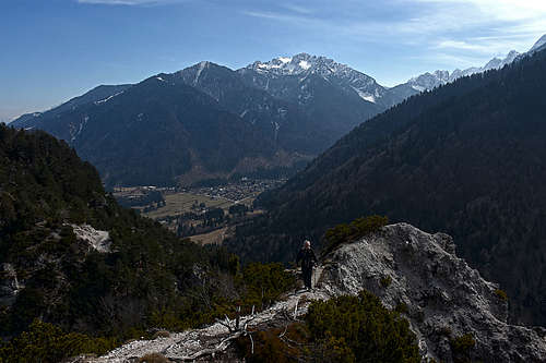
The views from the summit are also worth ascending there. In addition to those, running along Val Canale, some of the summits of Carnic Alps are seen, the majority of Malborghetto Chain and some peaks of the high part of Western Julian Alps. In the distance there are some summits of Western Karawanks and on the west some other summits of Carnic Alps.
Getting There

By the Val Canale the A23 highway runs, if you exit it near Camporosso, you are already very close to the two villages where the main trail heads for Monte Nebria are:
- On the western outskirts of Ugovizza / Ukve. For the NW route the trail head is at 46.510091814584115, 13.46370313712334.
- For the western road on Forcella Nebria the trail head is near Malborghetto: 46.50478244749159, 13.448999078618664.
- For the eastern road on Forcella Nebria the trail head is near the Julian Alps Chalet Resort, on the road to Valbruna / Ovčja ves: 46.50092517962139, 13.48442588426863.
Routes Overview
There are three main routes on the summit of Monte Nebria. They can be combined in round tours, to connect some of them, consider using also (mountain) bikes.
Reaching Forcella Nebria: Over this broad, grassy saddle (941 m) a mountain road goes, closed for public traffic. It starts on the W-NW near Malborghetto / Naborjet and on the E-SE in Valbruna / Ovčja vas. But the most recommendable is the 30 min trail from the east, from the trail head #3. You simply go westwards by a good path, higher mountain road.
-
Southern military road.
Difficulty: T3/ mostly T1. It starts on Forcella Nebria, 941 m. First it does two long turns, then (after being ruined - covered with landslide debris) goes through a tunnel (battery not needed), then the last 3 turns bring you just below the summit ridge. Before the road end, to the left (W) a path branches, bringing you on the saddle 1130 m, between the E and W summit. Then towards the W-NW by the a bit narrow and steep main ridge on the highest (W) summit - T3 difficulty (actually, it's more T2). 1 h altogether. -
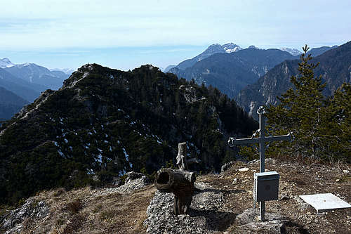
![On the summit of Monte Nebria East]()
On the summit of Monte Nebria East East ridge trail, No. 658
Difficulty: T2. It's marked, well beaten, in normal conditions quite easy. From the trail head #3 you start walking up towards the W (towards Sella Nebria), but already after some 200 m the inscription directs you to the right - across the creek. You pass by a big bunker, continue up the slope (cutting a cart-road turn), then towards the W and after a big right turn up again on the E ridge. Then more or less by the forested ridge or just below it till below the eastern summit. Near the main ridge you pass also a sink hole, secured by a wooden fence. The E summit is worth visiting as well - it's only a few minutes by a non-marked trail to the right. For the main summit you continue by No. 658 a bit more towards the W (slightly down), reach the end of military road and then immediately leave it. With a help of a metal wire you descend a steep scree and find yourself on the saddle 1130 m. Then on the highest point as on route #1. 1 h 30 min altogether. -
N-NW route
It comes up on the NW fore-summit directly from Ugovizza / Ukve. It's a good, not demanding ex military trail going up the forested slope in many turns (T2). Along the path there are many remains from the World War I. From the NW fore-summits it's only a few minutes to the main summit. 1 h 30 min.
When to Ascend?
You can hike up on Monte Nebria almost any time of season - by the military road, of course. Only hard winter with a lot of snow is not recommended, as the summit part of the route is narrow and can be tricky in deep or hard snow.