
-
 7801 Hits
-
 83.1% Score
-
 16 Votes
|
|
Mountain/Rock |
|---|---|
|
|
46.44378°N / 13.56800°E |
|
|
Hiking |
|
|
Spring, Summer, Fall |
|
|
6273 ft / 1912 m |
|
|
Overview
 Monte Re summit scenery
 From the N
 From the SW
 From the south
In comparison with the highest summits of Julian Alps, Monte Re is nothing special. Nor by its height, nor by beauty or climbing importance. It doesn't have high rocky walls, and as these are abundant in the neighbouring mountains, nobody goes in the crags of Monte Re. The highest attraction of this mountain is its panorama.
Because of a relatively isolated position, high above the valleys of Rio del Lago / Jezernica and Rio Freddo / Mrzla voda, Monte Re offers a great panorama, by which the mountain is known. Hikers are coming up almost exclusively from the southern side, from the town of Cave del Predil / Rabelj. Even if this town is on postcards allways shown with Cinque Punte / Pet špic (Five Peaks), these are too hard to become popular and the real home mountain of the town is Monte Re. The mountain belongs to Jof Fuart / Viš group. It rises in the ridge, dividing the before mentioned two valleys, being actually the last one, before the ridge comes down to the confluence of the two creeks. On the SSW the Sella delle Cave, 1334 m, is dividing Monte Re from other, higher mountains of the group. Over this pass a path connects the two valleys. Actually all the slopes of the mountain are steep, also rocky, and covered with dense woods and on top with pine bush. Just the last meters are grassy, allowing the famous panorama.
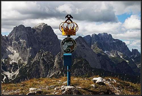
Andrej Mašera writes in his guidebook: "The legend says that the name of the mountain comes from the Langobards' king Alboin, who supposedly ascended the mountain in the year 568, to have a view on Furlania plane. That is highly unlikely, because the plane can not be seen from the top and the ascent is too steep and tiresome for a king. Still, the legend is here and on the top of mountain we don't have the usual cross or ciarn but a nice crown." In German language the mountain is called Koenigsberg.
The Mine
 Miners' cross on Piccolo Monte Re
Half of the SE face of Monte Re shows a terrific wound - the rest of a big zinc and lead mine, which was operating till 1991. There is evidence that the mine's origins are back in times of Ancient Romans, in 11th century it was already very big. End of 19th century the whole town was living for the mine and the evidence in 1959 shows that 1130 men were working in the mine. In 1961 around 65.000 tons were excavated. Today only a handful of maintenance workers are performing the last close-down tasks and the mine museum is being established.
One interesting feature of this mine is also a 5 kilometers long tunnel, connecting the mine and the valley of Koritnica on the Slovenian side of the border. The tunnel starts 240 meters below the level of the town and comes out on the other side in Log. In the past, waste waters were drained by the tunnel into Koritnica and further into Soča river and through the tunnel also workers from the Slovenian side were daily going on the job by a railroad. The tunnel was also of a great importance during the World War I and to a lesser degree in the World War II (partisans made a diversion in it, the consequence of which was that Germans killed all men in Strmec village). Today, there are plans to arrange the tunnel for tourist visits (thus establishing the deepest underground border crossing in the world), currently only the safety has still been the issue.
The geology of Monte Re is quite complex. Hiking on its top you will encounter mostly limestone (Trias period - the so-called Schlern Dolomit), which is covering the upper parts. But in the mountain there are intrusions of various minerals, from the volcanic Riofreddo intrusion to several others, resulting at the end in the masses, containing a lot of zinc and lead.
Summit Views
 Lago del Predil from Monte Re
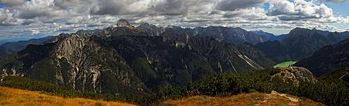 Mangart and Jalovec group - enlarge to see details!
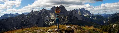 Viš and Montaž group - enlarge to see details!
The finest part of the panorama is the view on Viš group. We see it already quite from the side, we have a direct view on the summits above Rio Freddo / Mrzla voda, but the high summits of Viš and Montaž are also nicely seen. To be honest - the view on the group of Viš and Montaž from Cima del Cacciatore / Kamniti Lovec, from across Rio Freddo / Mrzla voda, is more beautiful and complete than the one from Monte Re. On the western side there are the high slopes of Cima del Cacciatore / Kamniti Lovec, towards the north the view is quite open to the lower hills above Tarvisio/Trbiž cauldron, and further to the Austrian mountains. The next important chapter is the eastern part of panorama. From Monte Re we are seeing the group of Mangart and Jalovec from a different perspective. Its wild northern part looks like a real chaos of limestone, because we don't see the valleys, going parallelly towards the main crest. The southern part of the group shows giant summits of the group - all like on a parade: Mangart, Jalovec, Pelc, Loška Stena. Right of this group we can also see a part of Krn group and more towards the right a part of Kanin/Canin group. A special attraction of Monte Re panorama is the view on Lago del Predil / Rabeljsko jezero, just south of our mountain.
 Towards the north Towards the north |
 Mangart and Jalovec Mangart and Jalovec |
 Mangart group Mangart group |
Other Interesting Features Nearby
 Rio delle Cascate waterfall
If you are in Cave del Predil / Rabelj, here are a few hints what to visit, in order to add some spice to the short tour on Monte Re:
- Lago del Predil / Rabeljsko jezero. Beautiful glacial lake with crystal clear water and a nice island, 1500 meters south of the town. Some hikers do a walk around the lake (3 hours 30 minutes), which is 1300 meters long and 500 meters wide.
- Rio delle Cascate Waterfall. On the southern side of Cave del Predel you go eastwards by the creek to a nice waterfall (10 minutes).
- The mine and its features.
The Lake Legend
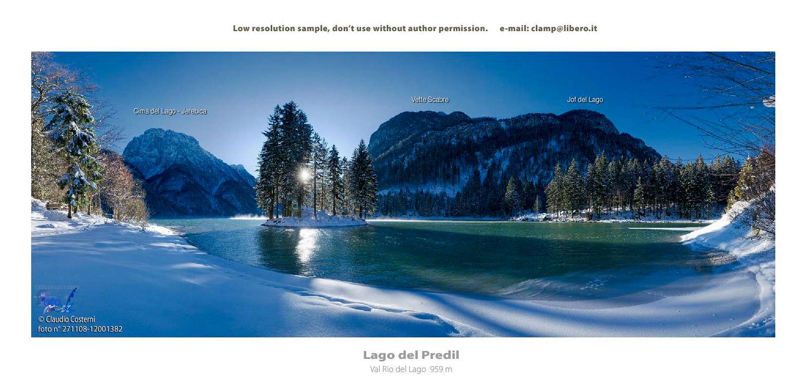 ClaudioNC - Lago del Predil in winter
Lago del Predil / Rabeljsko jezero lives with a legend which was recorded by a Slovenian poet Simon Gregorčič:
On the place, where today you see a big lake, once there was a beautiful and fertile valley. So, it was densely populated by people, but they were known as being very cold and hostile.
In one dark and cold winter night, when all the inhabitants of the village were warming themselves in houses by fireplaces, a poor woman with her young son came from far away in the village. Looking for help she knocked on all door, but nobody let her in. Only at the end of the village she saw a small house with a window warmly lit, she knocked, and was hospitably and with great care accepted by a family, gathered around a fireplace.
Soon afterwards a fierce storm raged over the valley. Strong winds were blowing, the earth was shaking. Strong, wild water streams rushed down the mountain slopes and the next morning saw a whole valley flooded. All houses disappeared, only the hospitable house at the end of the village, where the lady and her son were so kindly accepted, was spared, receiving sunshine on a small island. It's family was the only one rescued, while the Lady and her son (Madonna and Jesus) soon disappeared. Today they say, that when someone goes to the lake in Christmas night, he can still hear the bells of the sunken village loudly ringing. There's nothing to be seen today on the small island, however pictures from less than 100 years ago still show a small house on it.
Getting There
See the main area pages of Julian Alps how to get into Val Rio del Lago and Cave del Predil / Rabelj. There are three approach directions:
- From the north, driving from Tarvisio by the valley southwards up.
- From the south-west, arriving in the valley over the pass of Sella Nevea. Till there you drive through Raccolana valley, from the Udine-Tarvisio highway you deter in Chiusaforte.
- From the south-east, arriving in the valley over the pass of Predel/Predil (so, from Slovenia).
The trailhead for the ascent on Monte Re is practically in Cave del Predil / Rabelj town. On the SW side, where the entry into the big mine is, you can still drive some 50 meters up in Caroli resort, where you park. The road further on can still be passable by car, but the road is quite demolished, because since the mine is not operating any more, it is not being used much.
Ascent Route On Monte Re
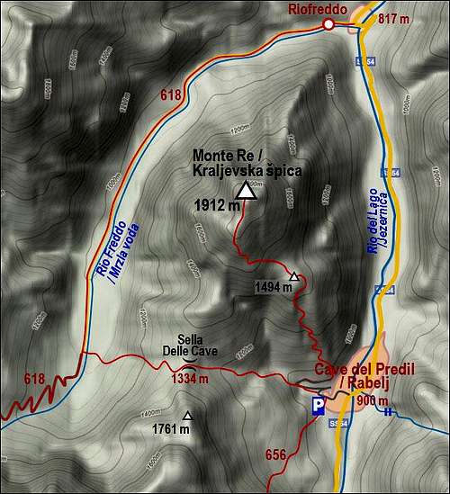 The map of Monte Re
From Caroli, some 950 m, you continue by the road along the Rio dei Combattenti creek. The road does two turns, on the third one you will see a marked path, deterring from the road westwards, towards Sella delle Cave. Don't go by it, continue by the road instead. It ends by a big mine building, where the trail on Monte Re starts (1023 m). The path was build and marked in 1977.
A well visible plate with inscription "Monte Re" directs you across the ravine (right), where you find a good, well beaten path. It is marked and you can not lose it, but the trail bears no number. Almost immediately the path starts ascending in many turns directly upwards. The slopes are steep, as on the whole mountain, the direction is northwards. The ascent itself is quite boring, we can amuse ourselves only admiring nice pine trees around and spotting perhaps time to time some view around. In good one hour and a quarter we reach a panoramic elevation, point 1494 m (Piccolo Monte Re), which is close to the half of ascent. Just below it we can go some 100 meters to the right and find the highest laying rests of the mine. On the point 1494 m there is an interesting cross, made of unusual materials and mine items.
After a few meters down the meadow, the trail starts to ascend again through the woods. There are even a few steep passages, a short rocky ledge and we are already on the more open southern ridge. Especially beautiful is the view on the nearby Viš group. The path by the ridge is cut in dense pine bushes. In the next 15 minutes we are on the southern fore-summit, then we go again a few meters down and in the next 10 minutes we are by the golden crown. Some 3 hours from the town, good 2 hours 30 minutes from the parking place above it.
Maps: Tabacco No. 019: Alpi Giulie Occidentali Tarvisiano. 1:25.000.
 Towards Viš Towards Viš |
 Summit ridge Summit ridge |
 The summit The summit |
Mountain Huts & Red Tape
No hut on the mountain, no red tape. Even if the nature is so devastated by the mine, in the upper part of the mountain nature is as beautiful as anywhere on more rarely ascended mountains.
When to Climb?
Monte Re can be climbed virtually any time of a season. Only when snow is deep, the ascent can become very hard. The southern orientation of the route guarantees that also during winter and spring the ascent can often be possible. The slopes are not very exposed to lavines, except, as said, when really there's a lot of fresh snow. Skiing from the top comes probably on nobody's mind.
Your Help Needed
Please add, if you have information:
- About ascent routes from other sides. Hunter paths from Rio Freddo valley?
- Winter ascent experiences.