
|
|
Area/Range |
|---|---|
|
|
42.90700°N / 19.40700°E |
|
|
7470 ft / 2277 m |
|
|
Overview
 Sinjajevina - Babji Zub (2277 m)
On the Tara - Piva (rivers) vast plateau Durmitor (2523 m) is placed on the northwest, while it's closest neighbour is placed on the southeast. That's the beautiful Sinjajevina mountain, one of most specific mountains of Montenegro. The older name for this mountain is also Sinjavina.
Geographically, this mountain belongs to the High Mountains & Plateaus Region of Montenegro. Some geographers classify Mt Sinjajevina a mountain plateau, but it also holds the largest pasture range in Montenegro. The direction of Sinjajevina follows the rest of the Dinaric ranges, from east to west.
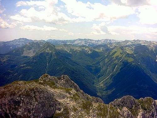
 Panorama of Babji Zub area
 On the ridge of Babji Zub (2277 m)
Geologicaly, it's composition is cretaceous limestone. From a morphological standpoint, this high mountain plain avarages 1600 m in height, with only these peaks of higher elevation: Babji Zub (2277 m), Jablanov Vrh (2203 m), Gradiste (2174 m), Savina greda (2101 m), Veliki Pecarac (2042 m), Starac (2022 m) and Babin Vrh (2013 m).
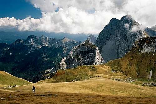
 Impressive massif of SINJAJEVINA
 Impressive massif ob Babji Zub (Torna, 2277 m)
 Stolovi group
Mt Sinjajevina's relief is rolling due to glacial activity. The complexity of this mountain is due to it's bordering rivers of Tara, Moraca, Tusinja & Bukovica. It stretches from SE to NW, from the towns of Kolasin to Njegovudje (near the Durmitor National Park). The Sinjajevina massif is 40 km long & 15 km wide, and is specific about it's carstic fields and beautiful grassy slopes. The soil composition is arid terrain due to the lack of forest covering and exposure, which has caused it's rather unique foliage.
The highest peaks of Mt Sinjajevina are:
- Babji Zub (2277 m)
- Jablanov Vrh (2203 m)
- Gradiste (2174 m)
- Sto (2172 m)
- Savina greda (2101 m)
- Veliki Pecarac (2042 m)
- Veliki Starac (2022 m)
- Babin vrh (2013 m)
- Sto (1959 m)
- Korman (1923 m)
- Mali Starac (1921 m)
 Winter climbing on Babji Zub (2277 m)
Mt Sinjajevina is also the home of 2 lakes:
- Zabojsko Jezero (1486 m, 19 m deep)
- Zminicko Jezero (1295 m, 4 m deep)
These lakes are in the process of natural extinction. Mt Sinjajevina has also numerous ponds nourishing it's existing livestock and wildlife.
The terrain is ideal for mountainbiking, and in the winter months for lengthy skiing. Mt Sinjajevina is easily accessible also from Durmitor National Park, what offer many possibilities for climbing and biking routes in Sinjajevina region.
LOCATION:
 Sinjajevina from Moracke Planine
Sinjajevina is placed in the heart of Montenegro, in it's central part, on the NW from Kolasin town and E from Savnik town. Sinjajevina is surrounded by many beautiful mountains and national parks. This beautiful mountain is situated on the SE from Durmitor National Park (2523 m), Maglic (2388 m), Bioc (2397 m), Volujak (2336 m), Ljubisnja (2238 m), on the NW from Prokletije (2694 m), Komovi (2487 m), Hajla (2403 m), Visitor (2211 m), Bjelasica (2139 m), Kucka Krajina Mountains (2184 m) and Mokra Planina (2003 m), on the N from Moracke Planine (2226 m), Maganik (2139 m), on the E from Golija (1942 m) and Vojnik (1997 m), on the SW from Kopaonik (2017 m), Golija (1833 m), Radocelo (1643 m), Zlatar (1626 m), Cemerno (1579 m), Javor (1519 m), Mt Zlatibor (1496 m) mountains in Serbia, on the W from Pester (1617 m) mountain in Serbia.
 Moracke Planine (2226 m) from the top of Sinjajevina
 |  |  |  |  |
Routes Overview
BABJI ZUB (TORNA, 2277 m)Coordinates: 42°51'47.5'' N ; 19°23'01.0'' E
Route: Kolasin town (940 m) - Gornje Lipovo - Klisura (1189 m)(T2) 1h - Katunina (1418 m)(T3) 1.30h - Djedov Do - Dzavrlje - Babji Zub (Torna, 2277 m)(T3+T4) 2.30h: 5h
Height difference: 1088 m
Lenght: 7.5 km
Duration: 5h
Trail: Partial marked
Registration book with stamp on Babji Zub (2277 m) summit
 Babji Zub (2277 m)
ACCESS: Gornje Lipovo and the settlement of Klisura (1189 m) is where the trails begins. The marked path goes above the locales of Katunina, steeply ascends through the forest, to 1600 m. It then goes above the forest and beside the rock through called Popov Do, then breaks through the Djedov Do valley Pass (1943 m). From this pass the view opens to Mt Maganik (2139 m). From there turn east, and then a slight descent northward along shortcuts through the rocky slopes of Torna and the former katun of Djedov Do. Continue to the end of this amphitheatre to Dzavrlje, a classic glacial trough. From this point there is a marked path leading west to the upper ridge Mt Torna. The ascent crosses steep grassy steppes, made up of loose stones that easily slide and represent a potential danger. On the highest peak of Torna - Babji Zub (2277 m), there is an official register book. The view from the summit includes the Plasnica Valley, the hamlet of Lipovo and towards the south, the Moracke Planine (Moraca Mountains, 2226 m).
As an alternative, the return from Babji Zub can be made by steep descent on a former livestock trail through the village of Redice, then to the settlement of Polje Dragovica (T3, 4h). Farther on, there is an asphalt road 14 km long to the settlement of Mioska on the Kolasin-Podgorica road.
JABLANOV VRH (2203 m)
Coordinates: 42°54'26.1'' N ; 19°24'25.4'' E
Route: Kolasin town (954 m) - Gornje Lipovo (1208 m) - Vratlo Pass (1730 m)(T2) 1h - Pilac (1872 m)(T2) 1h - Jablanov Vrh (2203 m)(T3) 1.30h: 3.30h
Height difference: 995 m
Lenght: 8 km
Duration: 3.30h
Trail: Unmarked
ACCESS: By car from Kolasin, through the village of Gornje Lipovo, to the village of Kaljica Selo, on a narrow asphalt road (13 km), following the Plasnica River ravine is where this route begins. From the settlement of Klisura, take the often winding gravel road to the Vratlo Pass, which is the entrance to the Sinjajevina plateau. The Jecmen Do katun (shepherd's cottage) is westward, but go eastward passing by the Pilac katun, a few shepherd's cottages. Continue east-northeasterly towards the steep and grassy slopes of Jablanov Vrh. This part of the ascent is strenuous and demanding but it is well worth the effort for it's splendid views of the Moracke Planine (Moraca Mountains) mountain range, with it's highest peak being Kapa Moracka (Lastva, 2226 m). There is a partial fence on the summit, once intended for a grave. From the summit southeastward, descent can be made to the Savina Voda (1782 m) spring, with a small reservoir of and artificial lake, offering nice refreshment and bathing during the summer months (1h-T2). From the Savina Voda spring descend through Savino Zdrijelo (1880 m), along a shepherd's trail to the Puletic katun and on the village of Gornje Lipovo (Knez Do)(2h-T2).
 |  |  |
Getting There
 Beauty of SINJAJEVINA
By plane:
The closest airport is the one in Podgorica (70km away).
If you are planning to come via Serbia, you can use the Belgrade (Beograd) Airport in Beograd (Belgrade) city, capital of Serbia and Montenegro.
Information about flights and tickets on JAT Airways web page.
By train:
Beograd - Bar (Bar - Beograd) railway passes through Mojkovac and Kolasin. In winter, there is a special ski-train for Kolasin from Bar and Podgorica. When you get off it, a ski bus will take you straight to the ski resort.
By Bus:
From Beograd (Belgrade):
Beograd (Belgrade) - Cacak - Uzice - Zlatibor - Nova Varos - Prijepolje - Bijelo Polje - Mojkovac - Kolasin
From Podgorica:
Podgorica - Kolasin
For the bus tickets and informations about but lines see Belgrade Bus Station page.
By car:
From Beograd (Belgrade):
Beograd (Belgrade) - Cacak - Uzice - Zlatibor - Nova Varos - Prijepolje - Bijelo Polje - Mojkovac - Kolasin
From Podgorica:
Podgorica - Kolasin
- Mojkovac - Kolasin road goes from the E side of Sinjajevina
- Mojkovac - Djurdjevica Tara road goes from the NE side of Sinjajevina
- Djurdjevica Tara - Savnik road start from the W side of Sinjajevina (lower quality of the road)
- Savnik - Kolasin goes on the SW side of Sinjajevina
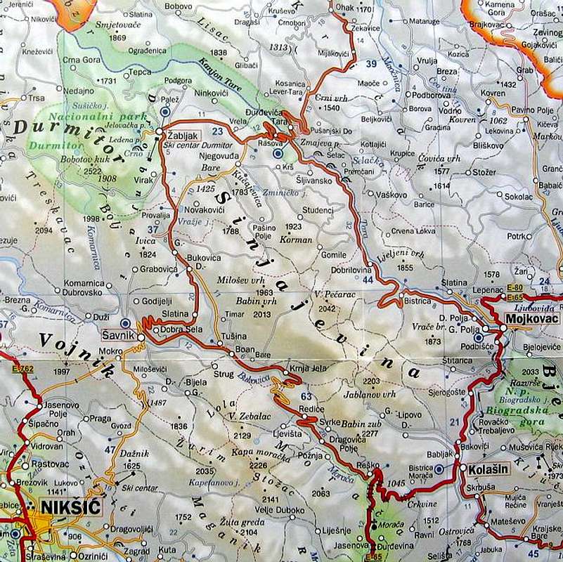
The map of Sinjajevina and it's surroundings
You should drive along the central Montenegrin highway, which connects the seaside to the towns: Cetinje - Podgorica - Kolasin - Mojkovac - Bijelo Polje; and goes on to Serbia (Belgrade city). This road is passable during most part of the year. It is closed only in case of abundant snowing or great rockslides. The landscape along the highway is particularly picturesque in the segment of the Moraca River Canyon between Podgorica and Kolasin. This part of the canyon is called “Platije”. The highway is built along the edge of the narrow canyon. Thus, you can enjoy in observing the beautiful contrast between steep, dark cliffs and light, green river, while round, white peaks of Bjelasica glow in the distance. At moments, this beauty becomes scary!
From Podgorica you can also take the village road for Kolasin. It goes across Lijeva Rijeka, Verusa and Matesevo. One part of it goes along the Tara River, which in this area is like a small, gentle and playful spring. The road is narrow, but in good condition. From the north, you will reach Kolašin if you take the highway that passes through Mojkovac. If you are coming from the east you should go across Andrijevica through Matesevo to arrive to Kolasin. You will be surprised by the difference in the landscape of the northern and the southern access to Kolasin. Unlike the south, the vegetation in the north is more lush, green and soft.
If you travel by car you will not depend on local bus routes. Buses are quite regular along the main roads, but if going by bus you will not enjoy as much in beautiful rural landscapes. In particular, the recommendation is that you do not take a bus in winter snowy days. It is better to rely on the train then, because roads might be impassable.
 |  |
When To Climb
Sinjajevina (2277 m) offer nice hiking and climbing adventures. The Sinjajevina peaks you can climb whole year. If the snow is hard and frozen, bring with you the crampons and ice axe.The best period for the Sinjajevina peaks climbing is mid June - mid October.
 |  |  |
Camping
In the Mt Sinjajevina (2277 m) area don't exist mountain huts, so you can freely use your private bivouacs and sleeping bags and put them belowe the peaks of the Sinjajevina. Also, you can use empty shepherd's lodges for stay inside. |
Mountain Conditions
The best meteo for Mt Sinjajevina (Kolasin town) is YUBC NET page. 5 days meteo, 4 times daily:Kolasin town
 |
Red Tape
No fees or extra fees for entering the Mt Sinjajevina.No permits needed either.
Usual rules of behaviour for NP's do apply.
 |