
|
|
Area/Range |
|---|---|
|
|
43.44000°N / 19.43000°E |
|
|
4908 ft / 1496 m |
|
|
Zlatibor
"Golden Pine Mountain"
"Golden Pine Mountain"
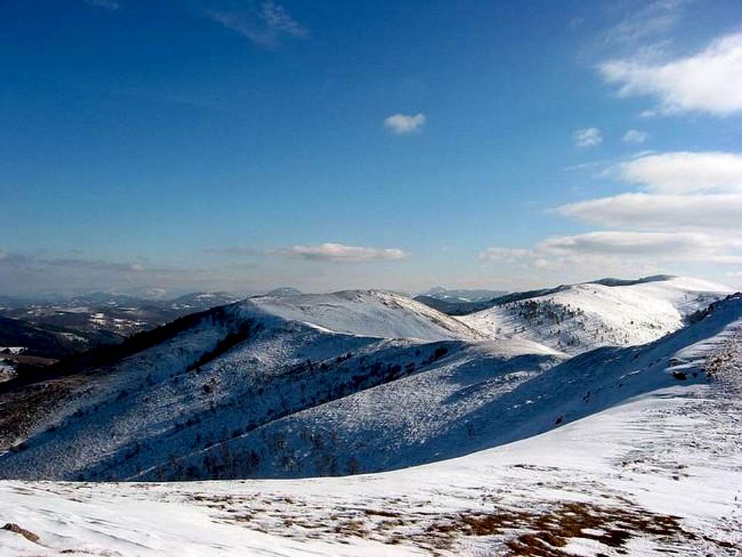
Cigota (1422 m) summit view
Name ZLATIBOR (ZLATI=golden, BOR=pine) means "Golden Pine". On Zlatibor you can see many pine trees and that's the reason why people called this beautiful Serbian mountain as "Golden Pine Mountain".
Zlatibor mountain is placed in the heart of Serbia, in its very central part, 230 km from Beograd (Belgrade), capital of Serbia and Serbia&Montenegro.
The Zlatibor Mt. is situated in the southwestern part of Serbia at the height from 700 to 1496 m above sea level (the highest peak is Tornik). The everage height of Mt. Zlatibor is about 1000 m above sea level. It is intersected by numerous rivers, streams and ravines.
Three highest peaks of Zlatibor massif are: Tornik (1.496m) - the highest peak of Zlatibor, Brijach (1.480m) and Chigota (1.422m).
Basis of Mt. Zlatibor is a spacious wavy plateau intersected by rivers and mountain streams and overgrown by thick grass and conifer tree forest. It is situated 27km away from Uzice town.
Territory of Zlatibor massif is more than 350 square km big, 30 km long and 12 km wide.
The central Zlatibor plateau is about 1000 m high in average, and there are a few easily visible peaks in the surrounding.
Zlatibor is, first of all, an extraordinary beautiful mountain, with a pleasant climate, with spacious sloping grounds, rich pasture-grounds and mountain brooks. There are about 1000 square km of meadows and risings, sloping grounds and dry grounds, abysses and chasms...
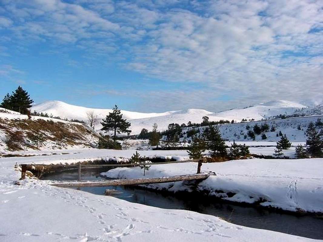
Winter scenery on Zlatibor mountain
Zlatibor as a geographical unit encircles the territory between the rivers Susica and Uvac and the eastern slopes of Mt. Tara and western slopes of Mt. Murtenica. The villages Kremna and Mokra Gora belong to it in the northwest, Mt. Murtenica, Zlatibor piedmont area, that forms a pass towards the nearby Tara and the Sandzak mountains, belong to it in the southeast.
Touristic concept of Zlatibor include the vast plateau 30 km long and 12 km wide, which spreads from northwest towards southeast, bordered by the mountain peaks of Gradina, Crni Vrh, Cigota, Murtenica, Tornik, Cavlovac, Vijogor and the upper course of the river Susica. On this place touristic settlements like Ribnica, Kraljeva Voda, Palisad, Oko and Cajetina started developing at the end of last and the beginning of this century.
The micro climate is very special here - there is a great number of sunny days during the year (more then 200), and the "rose of the winds" is flowering exactly above Zlatibor. Zlatibor is famous as an air spa where mountain and sea streams collide. The summers are hot and the winters are mild. It rains relatively often and there is a snow from October to May.
Zlatibor is declared as a therapeutic region, for all acute and chronic diseases of respiration organs, of thyroid gland, of all kinds of anemia , etc. The stay on Zlatibor is recommended for convalescence after infectious diseases and surgical operations too.
Zlatibor is, first of all, an extraordinary beautiful mountain, with a pleasant climate, with spacious sloping grounds, rich pasture-grounds and mountain peaks. There are about 1000 square km of meadows and risings, sloping grounds and dry grounds, abysses and chasms...
Nature was generous with Mt. Zlatibor giving it its beautiful scenery, rolling heights overgrown with pine, fir, and spruce forests here and there, vast meadows decorated with white narcissuses and other colourful flowers, very pleasant and mild climate, a great number of sunny days, unpolluted air and other amenities.
Owing to specific climate to harmonius relationship among wooded areas and spacious meadows covered with streams, unpolluted air, healthy and clear water, a great number of sunny days, wonderful ski terrains, characteristical air streams (continental and mediteranian), its suitable sea level hight, the most wanderful landscape, friendly hosts... Zlatibor has developed into a famous summer and winter tourist resort with the longest tourist tradition in Serbia. Current capacity of tourist objects is 6500 beds. Unofficially about 130.000 visitors spend about 600.000 nights on Zlatibor a year (in hotels, rest homes as well as in private rooms).
Mountain peaks:
A description of Mt.Zlatibor peaks from the book "On the fragrant Mt. Zlatibor", written by Sreta A.Popovich, published in Belgrade in the year 1908: "...Putting aside those braids of mountain saddles and hights we notice immediatelly, that on the very top of Zlatibor, in Dobroselica, Tornik (1496 m) raises proudly, decorated by a thick coniferous forest. On the north there is Sargan across which a road leads from Uzice to Bosnia and Hercegovina, and where the remainders of a Turkish bridge are still standing. On the southeast there is Murtenica, a famous mountain 60 km in the scope, richest with forests. It consists of many parts with special names and it is overgrown with fir forest, pine forest and hasel grove at the borders. On the northwest side of Zlatibor plateau there is Gruda with its stunted forests of cerris, oak and hornbeam and there is a nice view of Zlatibor from there. Another bigger peak is Gradina above Cajetina. As the air is as clear as crystal our glance pointed towards the southwest exceeds the present borders of Serbia and stops at the magnificent top of Durmitor. Komovi is to the south and we can recognise the blue shape of Sar Planina on the southeast. Let's turn now towards the southeast. The mountains Ovcar and Kablar are in front of us and they seem to be so near that you could throw a stone to them. To the right, from Rudnik a big crest of mountain branches off and Bukulja, Kosmaj and Avala raise there."
The highest peaks:
01) Tornik (1496m)
02) Brijach on Murtenica (1480 m)
03) Chigota (1422 m)
04) Konjoder (1337 m)
05) Chuker (1359 m)
06) Liska (1.346m)
07) Viogor (1281 m)
08) Borkovac (1.260m)
09) Kobilja Glava (1176 m)
10) Gruda (114O m)
11) Gradina (1149 m)
12) Crni Vrh (1177 m)
The Rivers:
Mt. Zlatibor plateau inclines towards the north and northwest, which caused that all the water flows off to the Black Sea basin by the Drina, the Djetinja and the Moravica. The rivers and streams are rich with various kinds of fish such as chub, gudgeon, traut, "mladica" and "lipljan". The strong river Uvac with its deep river bed and very nice canyons flows through the southern part of Zlatibor. Its tributaries are: the Shupljica in Negbina, the Rasnicki Potok (brook) in Rasnica, the Dobroselicki and the Sharanski potok in Dobroselica, and the Tisovica at Ojkovica. The Uvac flows into the Lim and later into the Drina. Crni Rzav has its headwaters under the northwestern parts of Mt. Murtenica in Carevo Polje and flows through the central part of mt. Zlatibor plateau. On some parts there are some very beautiful and interesting canyons. Its tributaries are: the Ribnica, Obudovica, Bele Vode, Jablanicka Reka. It joins the Beli Rzav and they form the Rzav which flows into the Drina. There are no other rivers in the northern part of Mt.Zlatibor except the Sushica, that has got its name because its water disapears into limestone during the summer. Its source is under Gruda and it flows into the Djetinja. The biggest tributaries are Dzambica Potok, Grabovica, Kriva Reka, Prijanski Potok and the Balashica. Veliki Rzav flows along the eastern border of Zlatibor. Its tributaries are: Bela Reka, Ljubishnica, Katushnica with its two tributaries the Rakovichki
and the Gostiljski Potok (where there is the waterfall from the picture, located behind the football field), and the Prishtavica with the Ponor.
The Lakes:
On Mt. Zlatibor there are two artificial lakes: The bigger one is in Ribnica on the river Crni Rzav. Its area is about 10 square km. It's rich with all kinds of fish, such as: chub, gudeon, traut, carp, tench and sheatfish.
In the very centre of the tourist town Zlatibor, the smaller lake, intended for tourist needs, is situated. It is surrounded by pleasant paths and benches for the visitors to have a rest. In summer they can swim and sunbathe there, and they can skate on its icy surface in winter (it is called "The Zlatibor Sea").
Legends about Zlatibor:
There are three legends about the origin of today's name Zlatibor ( ZLATI-BOR: zlato=gold, bor=pine tree): By the first one Zlatibor is supposed to get its name by white pine trees with yellow conifer (the colour of old gold), which used to cover the rolling slopes of Zlatibor. There has only one such tree remained (in the village of Negbina) and it was given the scientific name Pinus silvestris variegata Zlatiborica, by eng. Omanovich, who studied those conifer trees. In the second it is said that Zlatibor got its name because it was so rich with pine tree forests, that the immigrants from Montenegro and Hercegovina boasted: "It is really a pine tree made of gold!" The third legend says that it got its name by the mountain pastures, that get a yellow, a golden colour in autumn. Which of these legends is the right one make a decision by yourselves! Or, better come to Zlatibor, maybe you'll hear a new version in the song of Zlatibor pine trees!
History:
The first inhabitants of Zlatibor region were the Illyrians, namely their tribe Partyiny. The remnants of their culture -ornamental ceramics are being met in the caves and steep hights, where they used to live. Today these places are called "gradine" and there are three on Zlatibor (chajetinska, krivorechka, shljivovichka). In the museum collection of the library in Chajetina we can see some fragments of pottery with the characteristic decorative design engraved into the clay by a finger nail. The culture and life of the Illyrians have been studied exclusively from the "tumulus" (the tombs), which are found on Zlatibor in a great number on various locations (Krivorechka Gradina (the place Vishevina), Kremna, a wider area from Ljubish to Mushvet, Braneshko Polje).
At the beginning of our epoch the Romans dominate in this region with their culture much higher than the previous one.They build new fortreses, a net of new roads (Machkat - Chajetinska Gradina -the river Uvac). The Roman tombstones date the second and the third century A.D. Most of them are in Kremna and there are reliefs inspired by the motives from the nature and sometimes by God Atis - in the figure of a nice youth.
After the 9th century these places are being settled by the Slovenes, who also build fortreses and rebuild "gradine". There's a very interesting fortress on Gradac in Dobroselica, where we can see the remnants of a bulwark. There are some remnants of a stone pedestal in the shape of a bench that was probably used for observing. There are also some animal bones found built in the base (probably for religious reasons) and there is a lot of medieval material found on this location (a top of a spear, a knife, a copper ring...).
About the year 1180 Serbian King Stevan Nemanja connects Zlatibor and Uzice town to the independant Serbian state.
In the 16th century The unpreserved monastery Rujno was the cultural and educational centre of the former district (zhupa) Rujno. In that monastery one of the first Serbian printing shops worked. Recently the position of the former monastery Uvac (and maybe also of the Church Janja - being sung about in folk songs) has been discovered in Stublo on the river Uvac. According to traditional stories the monastery was that "Church Janja", which was the richest far around. The monastery possesed beautiful and good pastures above the valley on Orlic and Orahovica. Milk from there was transported to monastery by boats. The canals in which the boats were placed can still be identified. Thanks to researching and and work of the National museum in Uzice the monastery Uvac has been reestablished and the church with the "konak" (the overnight stay) have been rebuilt and sanctified. The church in Bela Reka is worth being mentioned among the old churches on Zlatibor. It has unusually small dimensions. It has only one nave and one cupola.
Etno Culture:
On Zlatibor characteristic churches "brvnare" (log cabins) were built, some of which still exist in Dobroselica and Jablanica. In many Zlatibor villages there are places called "crkvine" on which, according to tradition, wooden churches existed. It is supposed that some of them were being burnt by the Turks during the period of 1st Serbian rebellion like those in Mokra Gora and Kuchani, while the others, which survived the Turkish reign, became ruins because of their old age. The churches in Sirogojno, Chajetina, Ljubish, Machkat, Negbina and Shljivovica are ofrecent date.
Flora:
Characteristics of vegetation on Zlatibor on its serpentine ground is given by the forest community of Pinetum nigrae silvestris and vast pastures. That enables a great choise of interesting, rare and medicinal herbs. Some of them are:
~Gentiana lutea -"lincura" - medicinal (stomach problems)
~Teuricium montanum - "trava iva, ivica, gorski cmilj" - a medicinal herb (it is said: " ...this herb makes a dead man alive again"). It is antiseptic, it is good for stomach and intestine diseases.
~Achillea millefolium-"hajducka trava"- medicinal and good for honey
~Thymus serpyllum -"majcina dusica"- it has a calming and salutary effect
~Centarium erythraea -"kicica"- it improves digestion
~Symphytum officiale l.-"gaves"-for healing wounds and bone fractures
~Sorbus aucuparia L.-"jarebika"- a nice decorative bush or a tree
~Narcissus poeticus -"narcis", "zelenkada"- decorative meadow flowers
Endemic sorts:
~Halacsya sendtueri - "cvakija"
~Verbascum bosnense - "divisma"
~Haplophyllum boissieranum - "rutvaca"
A note: Some plants on Zlatibor are on the way to die out and they are under protection of the state,therefore citizens of Zlatibor are kindly asking all the visitors of Zlatibor to pick only as many plants as they need for their medicine.
Mushrooms: Besides the plants nature lovers can also find pleasure in picking mushrooms. The most frequent on these terrains are:
~Macrolepiota promineus -"suncanica"- (in high pine forests)
~Lactarius deliciosus -"rujnica"-(in young pine forests)
~Suillus granulatus -"vucji hleb","slinavka"-(on the borders of pine forests)
~Coprinus comatus -"gnojistarka"-(on moist fertilized meadows).
Caution! You mustn't drink any alcoholic drinks before and after the meal prepared with this mushroom!
 |  |  |  |
About Serbia
Geographical position:SERBIA is situated in the center of the Balkans, on the most important roads, which connect Europe and Asia, and covers the territory of 88.361 square kilometers. The length of the borders is 2.397 kilometers. In the east it borders upon Bulgaria, in the northeast upon Romania, in the north upon Hungary, in the west upon Croatia and Bosnia and Herzegovina and in the south upon Albania and Macedonian.
Serbia is the crossroads of Europe and geographically and politically important territory. International roads and railways, which pass down the valleys of its rivers, are the shortest connection between Western and Central Europe, on one side, and Near East, Asia and Africa, on the other side.
Serbia is in CET- central Europe time zone (GMT+1hour). Summer time is from the end of March till the end of October (GMT+2 hours).
Capital: Beograd (Belgrade): over 2.000.000 citizens
Currency: Dinar
Relief:
North Serbia, Vojvodina, is mostly a plain, while Central and South Serbia are hilly and mountainous. 15 of the mountain peaks reach the height of over 2000 meters, and the highest is Djeravica (2656 m) - (now on territory under UN protectorate) on Prokletije. Serbian rivers belong to the basins of the three seas- Black Sea, Adriatic Sea and Aegean Sea. Three of them are floatable: Danube, Sava and Tisa. The longest is Dunav (Danube). Its total flow is 2.857 kilometers and it flows 588 kilometers through Serbia.
Climate:
The climate in Serbia is temperate and continental with nuance between the four seasons. Summers are hot and winters are cold and snowy.
Population:
There are 7.478.820 inhabitants in Serbia (not counting Kosovo and Metochy), and that’s 94.1% of the entire population of Serbia&Montenegro. Serbs make 66% of the inhabitants, Albanians 17%, Hungarians 3.2% and then there are the Romanians, Romes, Slovakians, Croatians, Bulgarians, Turks, etc. The population is mostly of the Orthodox Christian faith. However, there are other religious communities: Islamic, Catholic, Protestant, Jewish, etc.
Language and letter:
In Serbia people use Serbian language of aecavic and iecavic pronunciation. It belongs to the group of south Slovenian languages and it is most similar to Bosnian, Croatian and Macedonian languages. A great number of our words are of a foreign origin, mostly Turkish and German, but today there are more and more anglicisms. Serbian language consists of 30 voices and two letters - Cyrillic and Latin characters. What makes it unique among other languages is a simple rule by which it is written and read: one letter for each voice and vice versa. You will mostly meet Latin characters, but the names of the streets and the information at the bus and railway stations and at post offices are written in Cyrillic. Therefor, it would be very useful if you learned the capital letters of Cyrillic, at least. Most of the young people speak English, less German, French and Russian, but Spanish and Italian are getting more and more popular, every day.
Currency: Dinar
 |  |  |  |
Getting There
No extra fees for paying. In Zlatibor center you have many places for parking. Near many renting houses also.By plane:
To Beograd (Belgrade) airport. Than by bus, train or car to Zlatibor Mountain (Belgrade-Zlatibor 230 km).
To Nis airport. Than by bus, train or car to Zlatibor Mountain.
Information about flights and tickets on JAT Airways web site.
By bus:
Beograd (Belgrade)-Zlatibor (directlly bus line, 230 km)
By train:
Beograd (Belgrade)-Uzice-Zlatibor
The main railway Belgrade-Bar (Montenegrin town on coast of Adriatic Sea) is going through Zlatibor and partly through its massif.
By car:
Beograd (Belgrade)-Uzice-Zlatibor (230 km)
The main-road which links Belgrade with the seaside crosses Zlatibor, direct bus lines are reestablished with Novi Sad, Belgrade, Nis, Jagodina...
Currency: Dinar
 |  |  |  |  |
When To Climb
You can visit Zlatibor Mountain and climb its highest peaks during whole year. That means - during all year seasons. Healthy air on Zlatibor is really something special! That's also my personal experience. |  |  | CampingYou can camping on many places inside of Zlatibor massif.In Zlatibor touristic center you have bakery, markets, milk shops, green market where you will find some speciallity of this area, for example - "kajmak" - very good milk creme, good chees, honey, and of course - famous "shljivovica" alcoholic beverage. Also, very famous healthy drink is "travarica", alcoholic beverage with minimum 12 herbs inside.
Mountain ConditionsThe micro climate is very special here - there is a great number of sunny days during the year (more then 200), and the "rose of the winds" is flowering exactly above Zlatibor. Zlatibor is famous as an air spa where mountain and sea streams collide. The summers are hot and the winters are mild. It rains relatively often and there is a snow from October to May.Zlatibor weather forecast 1 Zlatibor weather forecast 2
|


