
-
 8245 Hits
-
 81.84% Score
-
 14 Votes
|
|
Area/Range |
|---|---|
|
|
45.79818°N / 14.06722°E |
|
|
Hiking, Sport Climbing, Via Ferrata, Skiing |
|
|
Spring, Summer, Fall, Winter |
|
|
4308 ft / 1313 m |
|
|
Overview
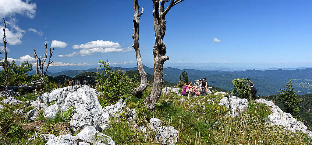
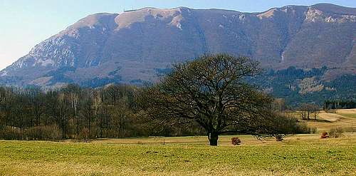 Nanos from the east
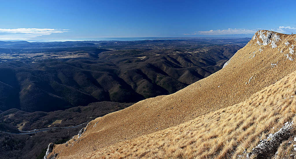
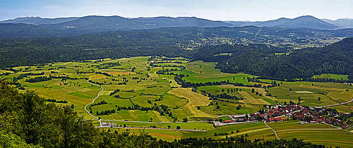
 The western slopes of massif from Podnanos village
 wuedesau - Planinska jama
As introduced on one of the greatest SummitPost pages, Dinaric mountains start on the NW with several moderately high mountains, rising from broad, mostly forested plateaus. The group of Trnovski gozd is most towards the NW, next to it, in the typical Dinaric direction - towards the SE - is stretching the group of Nanos. Its most characteristic mountain already has its page here on SP, unfortunately stagnating over the last years, but the whole mountain group offers much more. So, here I'd like to present a short overview. As these mountains are, except of the main summit, less attractive for visiting, allow me to mention on this page also a few other highlights of the area. At the end, mountains are not just peaks, but also their valleys, rivers, underground world and historical and cultural heritage as well. And in that broader aspect this is a great mountain group.
The summit of Nanos is besides Snežnik the second most famous mountain of Slovenian Dinaric mountains. Its characteristic dome is guarding one of the most important gates where the main traffic from European inlands goes towards the Adriatic sea - Postojnska vrata. Thousands of years this mountain is directing not only people traffic but also the cold "burja" wind which blows there from the continent towards the sea with its strongest force in average more than 40 days per year. Nanos is so characteristically seen from the south that it was serving as an orientation point even to sailors, reaching into some 50 km remote Trieste bay. It offers many nice hikes, biking tours, even short climbs in its crags. But that's more or less all why somebody enthusiastic about mountains would come to this areas. Other elevations of the group are only a bit lower, but none of them so imposing. Many are covered with woods, offering not much views around. What remains attractive with them is unspoiled nature and solitude. For skiing, these mountains are less attractive. The grassy slopes of Nanos are oriented towards the south and burja wind always spoils good conditions for skiing.
Geographical Facts

Borders of the Area
Nanos group has clear borders. On the south it is Pivška kotlina (Pivka Basin), a broad karst field named by Pivka river, meandring over it. On Hrušica Pass the high plateau drops down into Vipavska dolina (valley), bordering Nanos Group and further Trnovski gozd on the NW. The line Vipava - Col - Črni vrh - Godovič delimits Nanos group from the neighbouring Trnovski gozd. On the NE, the border between Julian Alps foothills and Nanos Group goes by the line Godovič - Logatec and further towards the SE the border between Nanos Group and Menišija / Javorniki by the line Logatec - Planinsko polje (karst field) - Postojna.
Subgroups
Roughly Nanos Group can be furrther divided into three subgroups:
- Nanos massif is the highest, rising on the very SW.
- Javornik is the area on the north, beyond the anciant trade route Col - Hrušica - Kalce.
- Hrušica is the lowest, SE area, excelling with other, non-mountaneous features.
The Character of Mountains
As other Dinaric mountains, also the Nanos Group is made of limestone. The chapter below describes the geology more in detail.
Almost all water, falling on the surface, disappears into the ground, forming the best examples of karst phaenomena. Water sources are only in the valleys, where the limestone layers are bordering to flysh. On karst fields, such as Pivška kotlina and Planinsko polje even bigger rivers disappear underground, showing up tenths of miles away, usually as rivers with different names. Underground is a totally different world. Rivers are confluencing there, forming tenths of kilometers long caves and deep canyons. Postojnska jama, one of the most famous and beautiful caves in the world, is more than 20 km long, for public visit only some more than 5 km are opened - and yet, that's supposedly the longest publicly opened cave system in the world. On the surface of those mountains you will see mostly endless forests. The exception is only the S and SE side of Nanos, where the slopes are grassy, steep and rocky. Due to forest exploitation the high plateaus are criss-crossed with a dense network of forest roads. To visit the area, don't miss to take a good map with you!
Geology
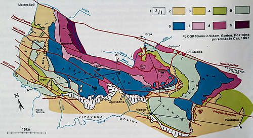
While the summits of Alps in Slovenia are almost exclusively made of triassic limestones, these are rare in the area between Soča and Ljubljanica river. Red colors on the picture left are showing that from upper triassic limestone (7) and dolomita (8, 9) only the northern summits of Trnovski gozd are made - those above Belica and Trebuščica. The highest summits of Trnovski gozd broader area are made of jurassic limestones (6), of lower cretacious limestones (5) and of from upper cretacious limestones (4). Almost around the whole mountain group in lower areas there is younger, eocena flysch (2), plus some paleocene limestones (3).
It's well known that in Vipavska dolina (valley) there's the border between limestone and flysch. Water of several strong water sources is rushing out on places, where it hits flysch layers, while due to limestone, on the surface of Nanos, there's almost no flowing water. It all disappears immediately. Also the karst sources on the northern side, for example Divje jezero, the wonderful source of vaucluse type, is bringing out waters of Trnovski gozd (and the plateau of Črni vrh), only that they are flowing through triassic limestone.
Trnovski gozd is significantly shaped also by geologic faults. The biggest of course have the typical Dinaric direction: NW - SE. Such faults are Raša fault (goes by Vipavska dolina) and the famous Idrija fault. The latter stretches from Italy across Slovenia into Croatia, straight as if it would be designed by a ruler. On Trnovski gozd one more fault is worth mentioning. The fault of Avče goes by the middle of the group, from the creek of Avšček on the NW to the basin of Pivka, where it dubbed the fault of Predjama. Due to it, the limestone faces in which the castle of Predjama is situated, are all perforated and the creek of Lijak all diasappears in those caves. Its waters are coming out on the other side of Nanos massif, in the sources of Vipava.
From Ancient Times
Strategic position of Postojnska vrata (pass) caused that south of Nanos in the past many peoples were migrating and trading. But strategy aside, near Postojna (Betalov spodmol) even evidence from paleolythic time (as much as 300.000 years back) was found. In pre Roman times near today's Šmihel supposedly there was a bigger, fortified cvastellum of Japodi tribe. Their era was ended with ancient Romans. From the times of Romans there is a lot of archeologic evidence around Nanos. At that time a trade route over Hrušica was popular, actually representing the shortest connection from the coast towards Emona (in today's Ljubljana) and Poetovia (today's Ptuj). Still today you can see the remains of Roman limes (defence wall with watchtowers) and on Hrušica pass explanatory tables teach you about the artefacts, seen on the site. And finally, on the SW border of Nanos mountain supposedly a big battle was fought. On the 6th and 7th September, 394, near the Frigid river (supposedly nowadays Vipava) a big clash happened between Teodozij, the emperor of the Eastern Roman Empire and Eugenij, the ruler of the Western Roman Empire. With Teodozij winning, Christianity prevailed also in at that time still barbaric Western part of Roman empire.
The Summits and Tours
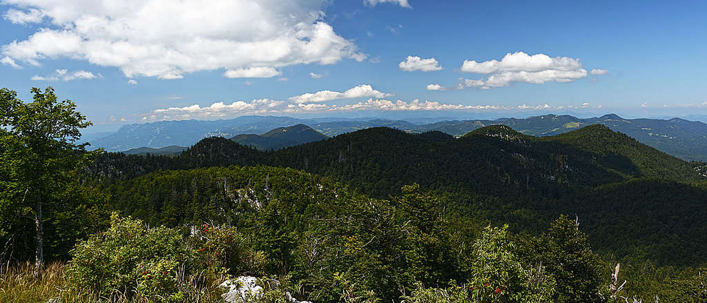
 The view from Pleša
Plesa, 1262 m
This summit is not the highest on Nanos, but far the most attractive and popular. It rises on the very south of the big dome of Nanos and so offers sweeping views towards the E, S and W. Due to its exposed position it hosts telecommunication devices, bringing signals to a big part of southern Slovenia. Pleša (="Baldy") can be reached by many attractive marked paths and also a narrow, at the end quite steep mountain road. Almost on the top also a mountain hut stands. Below are only a few route itineraries, al others are coming from more far away or are not marked.
Hikes
 Direct south route
1. From Razdrto, 575 m - direct south route. This is a very popular, medium demanding hike up (T3), steep and partially protected by a cable (short ferrata sections of difficulty A). We start on a parking place by the highway. At first we follow marks by a mountain road, then right by the marked path. It ascends over a meadow and through the woods to the place where the path branches (15 min till here). Our direct variant goes straight up. After crossing screes, the path soon reaches a rocky edge, around which a bit exposed ledge goes (picture left). This passage is protected by a cable. Then the path continues steeply and soon over a rocky slope a chain helps us. Above is a nice panoramic place from which the path continues left and then up by an open terrain. Also here some additional care is needed, especially if the slopes are wet or icy. High above the path gets less steep and soon branches. The straight branch goes over the top, the right one around and to the hut. 1 h 45 min.
 On the summit plateau
2. From Razdrto, 575 m - by St. Hieronim. This is an easy hike up (T2). We start as on #1, but on the crossroads continue left. Over meadows and later through the woods the path keeps crossing the slopes gently up, all the time towards the NW. Only the ascent over the rocky section is more steep. After reaching the slanted summit plateau, we find ourselves already above the cute church of St. Hieronim. There the path turns right and continues paralelly to the road on top. 2 h 30 min.
 Below the summit
3. From Veliko Ubeljsko, 589 m. This is an easy hike up (T2). We start in the village and continue by a cart road towards the north. After a few minutes the marked path deters left and goes straight up through light woods. At first we still have a rough cart road which soon turns into a broad path. It keeps running towards the left and up, getting more and more steep. After gaining quite some altitude, the path overcomes the steepest section with a few turns. There it is a bit deteriorated, but still not difficult or dangerous. Above, the path continues ascending towards the left, crossing nice grassy slopes. We reach the edge of a characteristic, nice beech forest, which occupies a distinct ravine and is seen clearly from the valley as one distinct characteristic of the mountain. By the grassy slopes we do a few light turns, reach the summit plateau and continue on top. 1 h 45 min.
4. From Strane, 664 m - by St. Bric. This is an easy hike up (T2). From the village we follow the road and later marked cart road towards the NW and then W. The path goes comfortably up through the woods, until we reach the crossroads. Towards the right there's only 5 min to the cute church of St. Bric, certainly worth a visit. From the church we descend back to the crossroads and from it continue left, in the SW direction by the broad path, always crossing the slopes up. Higher we reach the point, where towards the right another marked path branches - going on the forested plateau and further on Suhi vrh. But we continue straight and soon reach the open slopes with nice views down in the valley. After another light ascent the path starts crossing the summit plateau - all the way to the mountain hut and the summit of Pleša. 2 h 15 min.
5. From Furlan hut, near Abram farm, 900 m. This is an easy hike up (T1). We all the time follow panoramic mountain roads and comfortable marked paths over the slanted plateau towards the SE. 2 h.
Mountain Bike
 Biking up - Sv. Hieronim
6. Biking from Podnanos, 175 m. This is a quite strenuous and at the end also steep bike ascent on which we overcome more than 1100 m of altitude difference. If time allows, we can combine the tour by returning from the summit of Pleša to the crossroads and continuing to Abram farm and further towards the north into the valley of Bela creek. There, in summer we can refresh and then return to Vipava and Podnanos. That makes one of the greatest biking tours on the massif of Nanos. Otherwise, the ascent itself needs only a little description. A good road ascends in many turns from Podnanos in the NE direction. We cross the main road and ascend to the steepest slopes, which are overcame in several long turns. The path reaches the upper slanted plateau on 800 m, near the hill of Strmec, 850 m. From there, the road continues all the time towards the SE (two roads deter left towards Abram farm). The terrain is opened and very panoramic. We pass the cute St. Hieronim church and by the steep final ascent reach the mountain hut. From there, the panoramit summit of Pleša is just a few minutes away. Some 3 h.
Suhi vrh, 1313 m
 On Suhi vrh
This is the highest summit of Nanos group, but far less popular and also less panoramic than Pleša. It rises more on the eastern end of the narrow Nanos massif. Suhi vrh (Dry Peak) itself is again only an unsignificant, forested elevation, rising only some 50 meters out of the woods of Nanos plateau. The view from top is opened only towards the east and north. Two hikes are only described below. The third option would be from Abram farm. Just below the summit we could also reach by a bike, but that tour is not among the most attractive - due to many forest roads good map is needed and we basically need to return in the same direction.
|
|
Hikes
7. From Strane, 664 m - by St. Bric. This is an easy hike up (T2). As in #4 till the crossroads just below the church and then towards the SW till the path branches. We take the right branch and ascend at first more steeply, then quite comfortably in the northern direction, gaining enough altitude to reach the web of forest roads, coming over the plateu from the north. Following the marks we go past a forest house, continue some 500 more meters and finally deter right from the road. In the last 50 meters the ascent through the woods is again more steep. 2 h 30 min.
8. From Vojkova Koča, 1240 m. This is an easy hike up (T2). You reach the hut as described in itineraries of Pleša. From there you continue across the plateau towards the NE. The path is comfortable and well marked, going just a bit up and down. So you reach the crossroads, where the path right descends to Strane (see above #4), but we continue left, on the road and further by it past the forest house on top. 1 h 30 min.


9. From Strane, 664 m, by the Votla stena ridge. This is a very nice, panoramic ascent which is in the upper part a medium demanding hikeup (T3). On the meadows above the village we leave a cart-rad and a good, unmarked path (T2) leads us over quite steep, forested slopes in longer turns. After reaching the ridge, panoramic viewpoints start to appear and soon we gain the ridge summit of Maj, 1142 m (1 h 30 min till there). Then the path becomes much weaker and also goes up and also a bit down over some ridge elevations. If the path gets too weak or lost, you can always copntinue across the slopes on the right. A few traverses of steep, grassy slopes require some additional care, as they are also a bit exposed. On 1255 m the trail passes a nice natural rock window - you can easily descend those few meters to its nice lower part. Then we continue the ascent in the NW direction, easily following a weak path (more demanding orientation when going in the oppopsite direction). Below the Suhi vrh we hit the marked path and follow it to the right on the highes point. 2 h 15 min altogether.
Gradiska Tura, 852 m.
This elevation would be completely insignificant, but the NW slopes of Nanos are getting in the area above Vipava town very steep and rocky. Also higher crags appear there, so also climbing is possible and over those rocks an attractive ferrata goes. The crags are oriented towards the SW. The trailheads are in Gradišče, above Vipava, 250 m. Below, two routes are described, the third approach is a longer one, coming up on the plateau from Vipava town (2 h).
Hikes
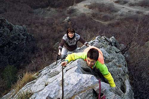 Gradiška Tura ferrata, 1998...
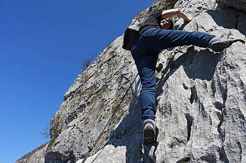 ...and 20 years later.
10. Furlanova pot (ferrata). This is a medium hard ferrata (B/C on the Austrian scale), on the ridge quite exposed. From the parking place we follow the marks in the SE direction till the crossroads above the village. While the right path goes right towards the church of St. Miklavž, we continue straight up. The path soon crosses a scree field and then ascends over an overgrown terrain. On the next branching we continue left, following the inscription "zelo zahtevna zavarovana pot" ("very demanding protected path". The first section is almost vertical (but of course properly protected), then again a bit less steep and then we again climb steeply up along a cable. Soon we reach a lookout plateau (artificial one), from which we continue right and up on an exposed, narrow ridge, where the path is again protected by cables. This is the most attractive part of ferrata. Above, the climb gets less steep and soon we reach the crossroads, where from the right the less demanding path comes up. The continuation is just a usual hike up, on which we must still gain quite some altitude. From the top the views down in Vipavska dolina and across the valley are quite nice. 1 h 45 min.
Additional option is the new Otmar's ferrata (Otmarjeva pot). It goes over the walls right of Furlanova pot and is longer. What is nice is, that it can be combined with Furlan's ferrata. After we climb this one, we descend some 50 m and then climb by the Otmar's ferrata on the very top of Gradiška Tura. Also Otmar's ferrata is very exposed, a bit harder than Furlanova pot, but its difficulty however still does not exceed the C grade by the Austrian scale.
It's a great idea to prepare in advance bikes up on the plateau! Then the return is quick and pleasant - via Sanabor village and Bela creek valley.
11. From Gradišče, easier route. We ascend as described in #9 till the second crossroads, but there continue right. By a short, well protected ledge we continue on a panoramic point, called Oltar. The continuing up is steep and on some places still protected with cables and pegs. Only higher the path gets a bit less steep and we reach the junction with ferrata (#9 route). Then by the path on top. 1 h 45 min.
Climbs
Some more than 20 routes are described. They are from 30 m to 250 m high and their difficulties are between 4b to 7a and on UIAA scale from III to VI+. Link (in Slovenian language): http://www.plezanje.net/climbing/db/showCrag.asp?crag=842
Vipavska Bela Climbing Area
 The creek of Bela
This is a quite popular set of crags along the creek of Bela, which encircles the narrow Nanos group on the western side. The valley is accessible from the road which connects Col with Ajdovščina. Besides sport climbing it is also a nice area for hiking and getting refreshed in ponds with clear water.
Climbs
There are more than 100 short (up to 20 m high) sport climbing routes in limestone, graded up to difficulty 8c+. Link (in Slovenian language): http://www.plezanje.net/climbing/db/showCrag.asp?crag=640
Javornik (nad Crnim vrhom)
This is a forested summit, which however hosts a lookout tower from which we have a nice panorama across the hilly Slovenia and beyond. SE below the summit, on 1156 m, Pirnatova koča (hut) stands. Both the hut and the summit can be accessed by many marked paths from all sides (at least 5 or 6 of them). They are all easy, crossing the woods and meadows of the massif. The hut can be also reached by forest roads which offer quite nice biking possibilities. The option which connects Hrušica with Črni vrh crosses Javornik massif and we can choose many different return options.
The ridge: Sv. Lovrenc, 1020 m, - Planinska gora
 On Sv. Lovrenc ski tour
 Sv. Lovrenc
The summits north of Studeno village are the highest elevations in Hrušica subgroup. Still they hardly reach over 1000 m of altitude. All of them are easily accessible by grassy slopes and are also connected by a marked path. A direct marked path also ascends Sv. Lovrenc from Studeno village (1 h 20 min). The views are opened only towards the south. While Nanos group is not much attractive for tour skiing, these summits are a bright exception. In normal winter they offer very nice downhills up to almost 500 meters of altitude difference. Their slopes are just properly inclined and it is enough that only some 30 cm of snow cover the grass. Special descriptions of hikes and ski tours are not needed - they are just evident when we reach Studeno.
The summits from the W towards the E are: Sv. Lovrenc, 1019 m, Špilnik, 1019 m, Lipovec, 1005 m, Petričev hrib, 937 m, Planinska gora with Grmada, 873 m. As said, they can be ascended separately, or all in one ridge tour. From Lohača settlement on the S side, a very useful road ascends on the plateau of Planinska gora. From the crossroads where it reaches the plateau, the easternmost summits can be quickly ascended.
Other Landmarks and Places Of Interest

Vipava Sources
Vipava is a nice old town and also the river which has source there, has the same name. The old castle above the town is nowadays in ruins, but the walls of otherwise closed Lanthieri castle down by the river still stand. The sources of Vipava are unique, because they have a delta shape. In the town there's many bridges, the most beautiful is the one behind Lanthieri castle. The whole place is worth of a short walk. The best time for visit is after a strong rain, when big quantities of water rush out of Nanos slopes.
Ad Pirum
This is a high passage on the ancient Roman road, which once connected Aquilea (on Adriatic coast) with Aemona (today Ljubljana) and further forts at Danube river. Later to the post station and fort a long defence wall (limes) was added. It was named Claustra Alpium Iuliarum, and was protecting Roman empire from attacks of barbaric tribes. Today a modest archeologic parc is arranged in Hrušica - Ad Pirum.

Predjamski Grad - Predjama Castle
This is one of the most picturesque castles in Slovenia. High, strong, impenetrable. Below a 123 m high, vertical wall Lokva creek sinks and there starts a more than 6 km long cave system in many levels. High above, under a huge natural arc, already in the 12th century, but documented in 1274, the first castle of Luegg family was built. The most famous owner was Erazem Predjamski, living there in the 15th century. For some a brave and noble knight, for others a vilain and robber knight. But it is certain that he opposed emperor, who finally ordered to Trieste Baron Gašpar Ravbar to subdue him. One year the Erazem's castle was at siege, but legends tell that even after that, the defenders were throwing down to Ravbar's soldiers fresh cherries and grilled chicken. They were getting regular supplies through a secret cave passage, which exited far away, in the middle of forests up on the high plateau. But finally a traitor revealed to Ravbar some of Erazem's patterns of moving. A well aimed cannon ball killed Erazem when he was on toilet. That was in 1484. Later, the castle was renewed and a renaissance palace was added. In that form we see it today.

Postojnska Jama - Postojna Cave
Many books are written about the cave of Postojna. It is one of the most beautiful karst caves in the world, and the first among big caves, which was arranged for tourist visit. Actually it is a more than 20 km long system of many caves, which were created by Pivka river and its tributaries. The cave was discovered already in 1818, but human presence in the cave is evidenced from even a more distant past. Already in 1884 the cave got electrical lighting and today a little train carries tourists through the first few kilometers. Annually, more than 500.000 visitors are recorded. They can admire very rich decoration and also a few endemic species of cave fauna (like proteus anguinus - a small, blind amphibian). Even if some other caves in Slovenia are even more magnificent, Postojnska jama is certainly worth a trip. The tourist site in English: http://www.postojnska-jama.eu/en/


Planinsko Polje - Planina Karst Field
This is a very beautiful, some 10 km long karst field, over which Unica river meandres. Just before reaching out, in Planinska jama (cave) there is a big underground confluence of two rivers: Pivka (which we know from Postojnska jama) and Rak, coming from the beautiful valley of Rakov Škocjan. Planinsko polje has a shallow layer of clay soil, so it is overgrown only with grass and swamp trees. In high waters every year the field is mostly flooded, but also when dry, it is very picturesque. There, also a few endemic plants are growing.
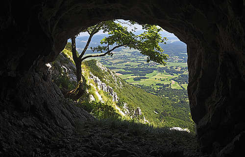
Votla Stena Natural Rock Window
On the massif of Trnovski Gozd there are three major rocks windows, all worth visiting. Votla stena is a strong ridge, descending from the Suhi vrh towards the SE. The name means: Hollow Crag and comes from the fact that on the altitude of 1255 m there's a nice rock window, piercing the whole ridge. Coming up by the ridge, the window is easy to find, coming down from the summit of Suhi vrh, a bit less so. But a path passes just by it.
Mountain Huts
In the broad massif of Nanos there are 5 mountain huts, among which actually only Vojkova koča near the summit of Pleša has some importance for hikers. Others are more or less only restaurants where one can get food and drink.
When To Visit?

In winter, the forested plateaus are covered with quite thick snow blanket. In those times more or less only the panoramic Pleša is visited by tourists. As said, for skiing only the grassy summits above Studeno are more interesting, the narrow Nanos massif only rarely has good conditions. The area is most beautiful in late spring and early summer (rich flora), but then often weather can be less stable and visibility less clear. Autumn is in Slovenian mountains always nice for hikes and climbs.