
|
|
Area/Range |
|---|---|
|
|
42.10286°N / 19.19367°E |
|
|
Hiking, Mountaineering |
|
|
Spring, Summer, Fall, Winter |
|
|
5230 ft / 1594 m |
|
|
Natural barrier between the Adriatic Sea and Skadar Lake
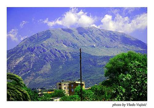 Rumija massif seen from Bar town
Stretching in NW-SE direction, Mt Rumija with its highest peak Rumija (1594 m) is the southest mountain of Montenegro. As a Dinaric natural barrier, Rumija separate Adriatic Sea from the Skadarsko Jezero lake. With the height of 1594 m, it drops steep towards the Adriatic coastline and somewhat less steeply towards the southern part of the lake. Rumija is very special and unique mountain with one leg in the Adriatic Sea and the other leg in Skadar Lake.
The elevation difference with more than 1500 m is one of the largest elevation difference in Montenegro, while the path from the Bar town to the summit is one of the most attractive mountain path in that contry. The ridge of the Rumija mountain is more than 10 km long and include Sutorman with its highest peak Široka Strana (1185 m) and Vrsuta (1183 m). Between the Bijela Skala pass and Rumija main summit is placed rocky ridge of Čagoglina (1297 m), while on SE are connected by ridge the peaks of Brisan (1435 m), Kozjak (1427 m) and Debelin (1205 m). On the south from the main summit and Veliki Mikulići is wide and roundly mountain Lisinja with its highest peak Loška (1353 m) which is nicely visible from the Bar town as a first visible peak. On the southern side of the mountain are placed few water springs and that are the three small rivers Železnica, Bunar and Međurječ.
Rumija & The Cult of St Vladimir
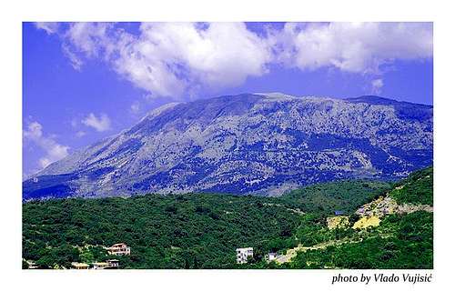 Rumija massif
Althought the Montenegro is the mountain country, the destiny of its citizens was to live with them. The thousends of years of the history of Montenegrin (Duklja) people was the reason why they glorify the mountains as a spiritual simbols. Two of them has the special importance for Montenegrin people, defending Montenegro and its people like some natural fortress. That are Rumija and Lovćen. During the Montenegro history, Rumija mountain was the first mountain with a strong spiritual influence was the Rumija, while after the 15th century the Mt Lovćen became a leading spiritual simbol of Montenegrins.
The proof of the Mt Rumija’s holiness in the last thousand years is a famous cross of St. Vladimir named as „Krst Svetog Vladimira“ or „Vladimirov Krst“. As a ruler of Duklja’s Montenegro, Vladimir was executed in 1215. when he came out from the church of the Sveti Ahilije in Prespa. After that, the God’s believers weare St Vladimir’s cross each year on the Holly Trinitty Day throught the Krajina (from Prečista Krajina as a spiritual centre of Duklja’s Montenegro) across the Rumija mountain and throught the Mrkovići i Anamale. After the execution of Vladimir, the spiritual ceremony of wearing of St Vladimir’s cross to the summit of Mt Rumija became a famous spiritual ceremony in which participate the Orthodox Christians, Catolics and Muslims. Vladimir was the first saint of Montenegro.
Each year on the Holy Trinitty Day the spiritual devoters weare that cross to the summit of Mt Rumija where is placed small Orthodox Christian chappel. That ceremony starting at the midnight when the believers start to weare St Vladimir’s cross to Mt Rumija from the church of Sveti Nikola (St Nicholas, Agios Nikolaos) in Velje Mikulića. The goal of the ceremony is to weare the cross to the summit of Rumija before the sunrise. When the sunrise come, the Orthodox priest bless the cross and rotate to all four sides of the World. On the summit of Rumija spiritual devoters make a spiritual prayer „Krst se nosi, Bog se moli, Gospode pomiluj!“ (The cross is wearing, Pray to God, God bless us!). Also, believers weare the rocks and stones to the summit because of theirs desire to build one day the church on the summit. After the priest blessed the people and after theirs finished prayers, the belivers descending from the Rumija and on the plateau below it continued to celebrate with singing, dancing, eating and drinking.
That spiritual procession is some kind of imitations of the Jesus Christ’s walk with a cross to the Golgota hill. After the execution of Vladimir, the spiritual ceremony of wearing of St Vladimir’s cross to the summit of Mt Rumija became a famous spiritual ceremony in which participate the Orthodox Christians, Catolics and Muslims.
Summit View
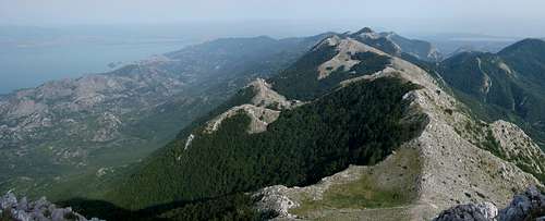 Rumija summit view
Rumija is a very special mountain because of its outstanding summit views and panoramas. From its summit you can admire the endless view above the Adriatic Sea, while on the other side you can enjoy in impressive sceneries and beauty of the large Skadarsko Jezero lake and many hilly islands on it. The highest and most impressive peak which you can see from Rumija’s summit is the highest peak of PROKLETIJE range Maja Jezerce (2694 m), placed in the Albanian part of PROKLETIJE massif.
Viewpoint: Rumija (1594 m) summit, N 42.102861 , E 19.193666
Mountain/ Height/ Air Difference
Maganik (Međeđi Vrh)/ 2139 m/ 69 km
Podgorica town/ 35 km
Kučka Krajina Mts. (Surdup)/ 2184 m/ 56 km
Prokletije (Maja Jezerce)/ 2694 m/ 63 km
Lisinj (Loška)/ 1353 m/ 6 km
Bar (Volujica Harbour)/ 25 m/ 8 km
Vrsuta/ 1183 m/ 10 km
Orjen (Zubački Kabao)/ 1893 m/ 73 km
Lovćen (Štirovnik)/ 1748 m/ 43 km
Garač (Milunova Bobija)/ 1436 m/ 51 km
Routes Info
 Rumija massif from Adriatic Sea
Bar Old Town (198 m) – Mali Mikulići village (788 m) – Rumija summit (1594 m): 4-5 h
The route to the Rumija mountain begin from the fortress of the old town of Bar. After leaving of Bar fortress, the path go out from the town and continue throught the gorge between the hills. First you can walk on the left side of stream, on the rocky path which is cut in the cliffs, where the stream is deep. After 20 minutes you’ll find the crossroad. The path go right over the bridge where one path goes to the left and the other one to the right. That one which go to the left in direction of Mali Mikulići village is the shortest one and most attractive. That path goes over rocky terrain near the Rikavac stream, surrounded by the cliffs. You should follow this path about one hour, when you’ll reach the Mali Mikulići village. On the entrance to that village the route go over the stream and become less steeper than before. You should follow the path near the stream and than go to the left side of the mountain ridge, while the main summit of Rumija (1594 m) is on your right side. After about 30 minutes you will go accross the Dobri Do valley and reach the pass, from where the terrain goes down to Veliki Mikulići village. From that pass the path go up on the left side of the forest, after that over the rocky terrain and through the another forest. After that the path is more steep till the pass. From Veliki Mikulići village to that pass you’ll spend about 1h, from where you’ll need more 30 minutes to the main summit of Rumija. The summit has the form of roundlly peak and it is placed on the left from the pass, on the end of higher rocky part of the mountain. The time for that route from Bar town to the summit of Rumija is 4-5 h.
The summit of Rumija you can reach also from direction of Skadarsko Jezero lake, from Livari village. The path go throught the Gornja Briska village, where you can choose to go to the Rumija summit or to Bijela Skala (903 m) pass, which is placed on the half between Rumija and Sutorman, 2 h of walking from Rumija summit. Bijela Skala pass is a natural connection between the Adriatic side and Skadar side of Rumija massif. From that pass you can descend to the Old Bar town via Mikulići village or Turčin village, or descend to Gornja Briska village in the direction of Skadarsko Jezero lake.
Gornja Briska village (476 m) – Rumija summit (1594 m): 4.30 h
Access: By car from the town of Virpazar to Ostros, the village of Gornja Briska (Livari) is located at the 28th kilometer of the Virpazar – Ostros road. It is 57 km from Podgorica.
The starting point of this route is from a rise surrounded by European chestnuts. From beneath the last house of the village, the path leads through a clearing for the first 45 minutes. The beginning of the ascent is from the entrance into shrubbery. From that point the SW trail becomes steeper. The first half of the path (2 hrs from the beginning) and a usual resting place is in the vicinity of a brick water trough (for livestock only), 1012 meters above sea level. A beech wood begins at this point and the path here is the steepest. From the wood, the path ascends to the crest (NW), follows it through a woody valley it reaches the pass east of the peak – from here some 25 minutes is needed to climb the peak. This trail is difficult. At least 2 to 4 liters of water is needed due to the high humidity. The way back is possible from the above passage down a steep slope towards the village of Veliki Mikulići.
Another option is to descend over Mala Rumija (smaller peak 1468 m) to the village of Mali Mikulići and on to Stari Bar (4h), or to continue in the same direction along the crest of Rumija to Bijela Skala pass (2h) and then by a well known Roman road either to the sea (4h) or to the Skadarsko Jezero lake (3h).
Gornja Briska village (476 m) – Bijela Skala pass (903 m) 3h - Rumija summit (1594 m) 2.30h; 5.30 h
Access: A narrow asphalt road leading from Virpazar to Ostros, at the 28th kilometer of this road is the village of Gornja Briska (Livari), or from Podgorica 57 km.
The starting point of the path is from a clearing surrounded by huge European chestnuts. From the last village houses, leave the marked path leading directly to the peak of Rumija. Contiunue west along an old Roman caravan road, rocky and quite visible, once a connection between the villages lying along the shores of Skadar Lake and the villages at the foot of Rumija mountain, towards the Adriatic. The route takes us through a rocky area and tree clusters, easily arriving at the Bijela Skala pass (overlook). At the pass, leave this road and turn left following the uppermost crest towards the Rumija summit, in a southeasterly direction over the crest of Čugagolina, through densely overgrown underbrush. Keep to the uppermost crest without moving away from it. On certain parts of this route there are some old paths that are barely recognizable, being overgrown and neglected.
The return from the peak is possible by also using a steep path following the crest towards the northwest over the Mala Rumija (1468 m) to elevation point 1347 m, then turn southwestward down a steep slope, passing the Lizalo spring to the village of Mali Mikulići and then on to Stari (Old) Bar. Another variation is to descend down the steep side of Ljuti Krš, SE of the peak to the village of Veliki Mikulići (2h) and through the village of Mali Mikulići to Stari Bar (5h). A third way is to descend in the direction of Skadarsko Jezero lake by a marked trail to the village of Gornja Briska (Livari)(3h).
Getting There
 Rumija massif
If you want to visit and climb the Rumija mountain, you should first reach Bar town on the Adriatic coast.
If you approaching Bar from Beograd (Belgrade), you can use a Beograd-Bar raillway, travelling during the night sleeping in the train, and then coming in the Bar town in the morning.
By plane:
The closest airport is the one in Podgorica (70km away).
If you are planning to come via Serbia, you can use the Belgrade (Beograd) Airport in Beograd (Belgrade) city, capital of Serbia and Montenegro.
Information about flights and tickets on JAT Airways web page.
By train:
Beograd - Bar (Bar - Beograd) railway
By Bus:
From Beograd (Belgrade):
Beograd (Belgrade) - Cacak - Uzice - Zlatibor - Nova Varos - Prijepolje - Bijelo Polje - Mojkovac - Kolasin - Podgorica - Virpazar - SOZINA Tunnel - Bar
From Podgorica:
Podgorica - Bar
For the bus tickets and informations about but lines see Belgrade Bus Station page.
By car:
From Beograd (Belgrade):
Beograd (Belgrade) - Cacak - Uzice - Zlatibor - Nova Varos - Prijepolje - Bijelo Polje - Mojkovac - Kolasin - Podgorica - Virpazar - SOZINA Tunnel - Bar: 10 h
From Podgorica:
Podgorica - Virpazar - SOZINA Tunnel - Bar: 1.30 h
If you travel by car you will not depend on local bus routes. Buses are quite regular along the main roads, but if going by bus you will not enjoy as much in beautiful rural landscapes. In particular, the recommendation is that you do not take a bus in winter snowy days. It is better to rely on the train then, because roads might be impassable.
Camping
 Rumija from Bar town
You can freely camping on many sides and places below, arround and on the Rumija mountain.
Weather Forecast
 Rumija from Adriatic Coast
Before your visit Rumija mountain check weather forecast for Bar town.