

-
 49757 Hits
-
 89.77% Score
-
 30 Votes
|
|
List |
|---|---|
|
|
Overview
Oregon has 74 peaks that qualify for the Prominence List with at least 2,000 feet of prominence. A new one, Echo Peak was recently added. Prominence measurements are typically abbreviated P2k or P5k for 2,000 ft or 5,000 ft of prominence respectively. This page is not meant to be a primer on prominence. The Oregon P2k List has been compiled by Edward Earl, Andy Martin, and Aaron Maizlish. Prominence is further discussed on this site. I have climbed all these peaks, so contact me directly for any more info that you may need concerning this list. Another wonderful site for keeping track of your Prominence Peak totals is The Contiguous US 2,000' Prominence List hosted by John Kirk.
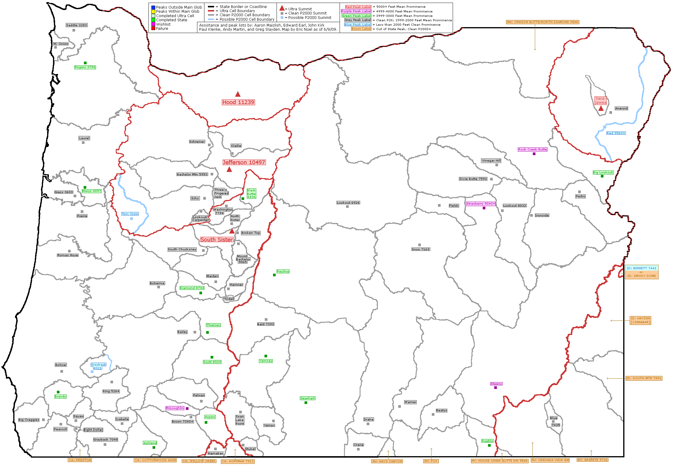
The Oregon Prominence Peaks include many of the famous most often climbed peaks in the state. There are many others that most people have never heard of. Some of these peaks are long difficult or technically difficult climbs. Others are virtual drive-ups or short hikes. These peaks are spread geographically around the state and by visiting all the peaks you will view virtually every county and every corner of the state. If you climb all the county highpoints in Oregon you will have only climbed 16 of the peaks on this list. For a map of the P2k's in Oregon that was tediously compiled by ericnoel follow this Link . This is an interactive map that you can keep at home and color the appropriate cells as you complete the climbs.
I will provide links to all SP pages that are referenced on this list. If the information provided on those SP pages is inadequate for your needs, please contact me for more info. I will also provide links to Topo Zone maps for each peak. Mountains that do not have SP pages, I will give a brief description under the appropriate section heading that is referenced on the Table of Contents. Suggestions for improving this list are eagerly solicited.
If you have hiked many of these peaks, send me your totals and I will add your name to the Section about P2k Completers and Other in Progress Totals.
Oregon Prominence List
| Oregon 2,000 ft Prominence Peaks | |||||
|---|---|---|---|---|---|
| Rank | Peak Name | County | Elevation | Prominence | Topo Map |
| 1 | Mt. Hood | Clackamas/Hood River | 11,239 | 7,679 | Map |
| 2 | Sacajawea Peak | Wallowa | 9,838 | 6,388 | Map |
| 3 | Mt. Jefferson | Jefferson/Linn | 10,497 | 5,777 | Map |
| 4 | South Sister | Deschutes/Lane | 10,358 | 5,588 | Map |
| 5 | Rock Creek Butte | Baker | 9,106 | 4,466 | Map |
| 6 | Mt. McLoughlin | Jackson | 9,495 | 4,455 | Map |
| 7 | Steens Mtn. Range HP | Harney | 9,733 | 4,373 | Map |
| 8 | Strawberry Mtn. | Grant | 9,040+ | 4,080 | Map |
| 9 | Brandy Peak | Curry | 5,298 | 3,618 | Map |
| 10 | Gearhart Mtn. | Lake | 8,370 | 3,430 | Map |
| 11 | Marys Peak | Benton | 4,097 | 3,357 | Map |
| 12 | Mt. Thielsen | Douglas/Klamath | 9,182 | 3,342 | Map |
| 13 | Paulina Peak | Deschutes | 7,984 | 3,214 | Map |
| 14 | Yamsay Mtn. | Klamath | 8,196 | 3,176 | Map |
| 15 | Mt. Ashland | Jackson | 7,532 | 3,132 | Map |
| 16 | Big Lookout Mtn. | Baker | 7,120 | 3,120 | Map |
| 17 | Diamond Peak | Klamath/Lane | 8,744 | 3,104 | Map |
| 18 | Aspen Butte | Klamath | 8,208 | 3,088 | Map |
| 19 | Black Buttte | Jefferson | 6,436 | 3,076 | Map |
| 20 | Pueblo Mtn. | Harney | 8,635 | 3,035 | Map |
| 21 | Rogers Peak | Tillamook | 3,706 | 3,034 | Map |
| 22 | Mt. Scott | Klamath | 8,938 | 3,018 | Map |
| 23 | Mt. Bailey | Douglas | 8,368 | 2,968 | Map |
| 24 | Vinegar Hill | Grant | 8,131 | 2,851 | Map |
| 25 | Laurel Mtn. | Polk | 3,589 | 2,829 | Map |
| 26 | North Sister | Deschutes/Linn | 10,085 | 2,725 | Map |
| 27 | Mt. Bachelor | Deschutes | 9,065 | 2,665 | Map |
| 28 | Pearsoll Peak | Josephine/Curry | 5,098 | 2,618 | Map |
| 29 | Maiden Peak | Deschutes/Lane | 7,818 | 2,578 | Map |
| 30 | Mt. Washington | Deschutes/Linn | 7,797 | 2,554 | Map |
| 31 | Drake Peak | Lake | 8,408 | 2,548 | Map |
| 32 | Swan Lake Point | Klamath | 7,260 | 2,540 | Map |
| 33 | Eight Dollar Mountain | Josephine | 4,001 | 2,521 | Map |
| 34 | Three Finger Jack | Jefferson/Linn | 7,841 | 2,481 | Map |
| 35 | Lookout Mtn. | Crook | 6,926 | 2,426 | Map |
| 36 | Schreiner Peak | Clackamas | 5,720 | 2,360 | Map |
| 37 | West Onion Peak | Clatsop | 3,076 | 2,356 | Map |
| 38 | Hamner Butte | Klamath | 7,098 | 2,338 | Map |
| 39 | Crane Mtn. | Lake | 8,456 | 2,336 | Map |
| 40 | Saddle Mtn. | Clatsop | 3,283 | 2,323 | Map |
| 41 | Fields Peak | Grant | 7,362 | 2,322 | Map |
| 42 | Bald Mtn. | Klamath | 7,393 | 2,313 | Map |
| 43 | Dixie Butte | Grant | 7,592 | 2,312 | Map |
| 44 | Mt. Isabelle | Jackson | 4,494 | 2,294 | Map |
| 45 | Grayback Mtn. | Josephine | 7,048 | 2,288 | Map |
| 46 | Mt. Bolivar | Coos | 4,319 | 2,279 | Map |
| 47 | Bachelor Mtn. | Linn | 5,953 | 2,273 | Map |
| 48 | Prairie Peak | Lane | 3,422 | 2,262 | Map |
| 49 | Olallie Butte | Jefferson/Marion | 7,215 | 2,255 | Map |
| 50 | Hamaker Mtn. | Klamath | 6,596 | 2,236 | Map |
| 51 | Bohemia Mtn. | Lane | 5,990 | 2,230 | Map |
| 52 | Ironside Mtn. | Malheur | 7,811 | 2,211 | Map |
| 53 | Odell Butte | Klamath | 7,032 | 2,192 | Map |
| 54 | King Mtn. | Jackson/Josephine | 5,265 | 2,185 | Map |
| 55 | Broken Top | Deschutes | 9,175 | 2,175 | Map |
| 56 | Grass Mountain | Benton | 3,603 | 2,163 | Map |
| 57 | Pelican Butte | Klamath | 8,036 | 2,156 | Map |
| 58 | Snow Mountain | Grant | 7,163 | 2,123 | Map |
| 59 | Echo Mountain | Linn | 5,830 | 2,120 | Map |
| 60 | Warner Peak | Lake | 8,017 | 2,117 | Map |
| 61 | Lookout Mountain | Baker/Grant | 8,032 | 2,112 | Map |
| 62 | Aneroid Mountain | Wallowa | 9,702 | 2,102 | Map |
| 63 | Squaw Mountain | Josephine | 4,702 | 2,102 | Map |
| 64 | Big Craggies | Curry | 4,619 | 2,099 | Map |
| 65 | Roman Nose Mountain | Douglas | 2,856 | 2,096 | Map |
| 66 | Yainax Butte | Klamath | 7,226 | 2,081 | Map |
| 67 | Blue Mountain | Malheur | 7,435 | 2,075 | Map |
| 68 | Brown Mountain | Klamath | 7,340 | 2,058 | Map |
| 69 | Stukel Mountain | Klamath | 6,525 | 2,058 | Map |
| 70 | Pedro Mountain | Baker | 6,455 | 2,055 | Map |
| 71 | Beatys Butte | Harney | 7,918 | 2,055 | Map |
| 72 | South Chucksney Mountain | Lane | 5,795 | 2,035 | Map |
| 73 | Carpenter Mountain | Linn | 5,349 | 2,029 | Map |
| 74 | Grayback (Douglas) | Douglas | 4,022 | 2,002 | Map |
Completers and Others
UPDATE: Congratulations to Nick Turtura who completed all the peaks on the list on 9-6-14 by getting to the summit of
Mount Jefferson. Nick joins Dennis Poulin, Bob Bolton and Ken Jones as the 4th to finish the demanding list. Well done.
All of the Oregon completers and those who are doing well in collecting the Oregon prominence peaks can be found at the front runner list kept by Greg Slayden's fine peakbagger.com page.
Here is the link that will take you to that list:
Oregon prominence front runner list for the peaks with 2000 feet of prominence
If you are not a member of peakbagger.com, please consider joining and entering your information. It is one of the best web sites out there and
has a wealth of information as well. A modest donation of 20 dollars a year will help the webmaster keep adding more and more features as well as help defray his expenses.
Laurel Mountain
Laurel Mountain (3589 feet) is one of the more difficult mountains on this list to get. There is nothing technically difficult about it, it is because it happens to be on a Federal FCC site and because access is through two gates, one owned by Weyerhauser Logging company, and the second gate (the government one) is posted for "no trespassing", getting Laurel Mountain is a tough chore.
Laurel Mountain is also the county highpoint of Polk county and as such attracts those who are chasing after the Oregon County highpoints. First, to get through the first gate, the Weyerhauser one, you have to wait until hunting season when Weyerhauser opens the gate to hunters for a total of three or four weekends in November. The rest of the year that gate is locked. Assuming you get through the first gate, then there is the issue of getting through the second one, the one posted for "no trespassing" by the federal government.

Is it impossible to get permission to access the highpoint? The answer is "no" but you must go through proper channels to get permission or risk finding out if the government is a paper tiger on this trespassing business. Read this posting found at cohp.org. I've linked it HERE.
OK, now you've touched all the bases, planned to go when the Weyerhauser gates are opened to the public (only on specific weekends in the fall), you head for Dallas Oregon and from there to Fall City, Oregon. Take the main road west out of town up the Little Luckiamute River (drive slow, lots of chuckholes), past Camp Tapawing and the Gerlinger State Forest. I don't remember where the Weyerhauser gate is but the road turns north around Riley Peak, and later watch for a junction on the right leading to the FAA tower. The gate is about 3/4 mile in from the junction.
At the gate, the road is easily walked ( between a half mile and three quarters of a mile)until you see the FAA tower. The road goes a bit east of the FAA complex and then curves back to the west towards it. You'll see a fence, a field and a treeline. The highpoint is just to the east of the fence but north of the road and you will be able to figure out where it is. Its not in the trees and when you stand on the highest ground, you are easily visible from the windows in the FAA complex. A benchmark is near by.

Check out this LINK for more info and a picture of Laurel Mtn.
Camping: Day hike this one
Weather: Rain or shine works.
Cautionary advice: Should you choose to do this one without gaining permission, you may find out what the local law enforcement agency looks like.
---------------------------
SP member Dundeel added this information about his recent visit to Laurel Mountain:
I started my search for FAA permission to visit this site, by calling the numbers Dean Molen provided in his cohp report. I was referred back to the regional office and told to talk to Toni Watkins-Cline (503-258-6981, Toni.Cline@faa.gov ). She was very helpful and was able to get permission for me within a couple of weeks. I recommend that you send an e-mail request to Toni with a description of the vehicle you intend to use, the date you would like to visit, and contact information. I came in when the gates were open for hunters, but if you want to go at a different time of the year, try Weyerhauser Land Use Manager, Scott Marlega, 541-451-8206.
The FAA does request that no pictures be taken at the site. The site is frequently visited by FAA personnel and is monitored by CCTV. I carried a copy of my e-mail permission with me in case anyone asked.
Posted Jan 12, 2007 10:38 pm
Swan Lake Point
Swan Lake Point is another of those great viewpoints that has its summit area cluttered with man made structures. Still, the views are impressive but this one is generally a drive up. I mention generally because when two of us did it, we ended up with an eight mile hike on the snow. Dennis was able to drive up from the northeast via the Sprague Valley road. He stated that east of milepost 10 on the Sprague River Road, FS 22 heads south. Staying on FS 22, he drove about 9 miles to FS 9718 SW until about milepost 15 where he took FS 740 to the summit area and parked. A few steps and he was to the highpoint, in the bushes at the west side of the summit area. Look for a Benchmark and you've found it.
Bob and I accessed the peak from US 97 on the west and it involved 11 miles of driving and 8 miles of hiking, roundtrip (in the snow). For the route from the west, check the attached map.

Klamath Falls Weather (Klamath Falls is the nearest town of any size)

Campgrounds: At the beginning of the road, just off of US 97, a county park provides camping. Since it is right next to the road, you will find that the roar of trucks may hamper your sleep. Still, there are about 6 spaces with a restroom at that CG. Other campgrounds near by are Collier State Park, a modern campground with showers and flush restrooms.
An Indian Casino is also nearby at Chiloquin as is the southern entrance route to Crater Lake National Park.

West Onion Peak

West Onion Peak is about a mile west of Onion Peak . Read about Onion Peak on the SP page linked above. Access to both peaks is up the same logging road.

This area has active logging activity. I visited on a weekend and there was no one around. There was logging equipment along the road, but it did not interfere with my hike. DO NOT FOOL AROUND WITH THE LOGGING EQUIPMENT. Loggers are very sensitive individuals and can become somewhat agitated if they think you are one of them environmentalist tree huggers.


The sign on the gate said it was owned by the Stimson Lumber Co. who bought it from the Weyerhauser Corp. Hiking was allowed but not any more. Not even to hunting during the hunting season according to Karl Helser who put up the SP Onion Peak page. He lists the Stimson phone number as: 503-357-2131 . Recommendation- do this at your own risk but if you do it, go early and on a weekend.
This is a fairly long hike of about 12 miles and about 3,100ft of elevation gain. It took me (Dennis) 6 hours. Refer to the topo I have uploaded and hike up the road about 5 miles to Onion3 Waypoint. At this point follow the rough 4WD road off to the left. This road goes a little ways to a campsite and then switchbacks sharply back to the left. The road is overgrown here, but you can make out the road bed. Follow it up to an old log landing where it ends. The summit is up some boulders to your right. I found a couple boulders that may have been the summit, but it was overgrown on the summit. Look around until you are sure you found the highpoint.


This is actually a nice hike on a clear day. Since you can't park at the gate, consider parking at Hug Point State Park. Hug Point is about 1/3rd of a mile away and makes a good place to park your car. Hug Point is day use only so you can't park or camp there overnight. It is nice to combine a bit of the beach with a mountain hike, very unusual and rare.

Hamaker Mountain

Top of Hamaker Mtn
Hamaker Mountain is a drive up. A paved road takes you right up to the summit area which is occupied by a large FAA dome structure. Unfortunately the high point is behind a barbed wire fence which is strongly marked by a large sign that indicates that trespassing will not be tolerated. I wouldn't cross that fenceline for any amount of money or fame so my suggestion in this case is to walk the fenceline until you come to the highest point and call it a reasonable substitute for the actual highpoint, which you can see from there.
How to get there:
Drive southwest from Klamath Falls on highway 66. Drive past the small town of Keno and look for the Hamaker Mtn road a couple miles to the west of town. Drive up this road for about ten miles to a flat parking area near the top of the mountain. Great views back towards Klamath Falls and of Mt. McLoughlin. The FAA structure dominates the view to the south and the fence keeps you on the parking area side. From the parking area, it is less than 150 feet to the fenceline. Note the large warning sign and obey. DO NOT cross the fenceline (barbed wire top and all).
Weather: Click HERE
King Mountain

King Mountain is a drive-up that is close to I-5. I’ve seen many summits with communication towers on their summits, but very few with more than King Mountain. This is an easy drive off of I-5 that takes about 30 minutes each way. Any 2WD vehicle should be able to make this drive unless there is snow on the road.

King Mountain is near the point where Josephine, Jackson, and Douglas Counties all come together. It looks like the summit is in Josephine County, but you could throw a rock and hit Jackson and Douglas Counties.

To find this summit, exit I-5 in the town of Wolf Creek and find the road heading east towards the berg of Speaker. Speaker only has about 4 buildings, but it is on the map. The road is on the north side of waterway of Wolf Creek. The berg of Speaker is about 4.0 miles from the town of Wolf Creek. Zero your odometer in Speaker. In 1.0 mile turn left and start climbing, at 4.0 miles go right, at 4.3 miles turn sharply left, at 5.9 miles there is a big intersection turn left here, at 7.2 miles turn left, you are almost there, continue climbing up the hill and at 9.4 miles turn right towards the summit, drive the last .7 mile to the summit and all the communications towers and buildings. There is a gate just before the summit that may be closed at times. It was open when I was there, so I drove to the top.

This is public land but I'm not sure which agency owns it. It is probably BLM land. There are great views to the east and west from the summit. I could see Mt. Mcloughlin peaking up in the east and it seemed like I could see the Pacific Ocean if it was a clear day looking west.
Grants Pass Weather
Snow Mountain

Another Oregon prominence peak that has a functional lookout. At 7183feet high, it is a dominant mountain in this area. A road leads to the summit and a 2WD vehicle with high clearance could most likely get close to the summit with careful driving. Two of us approached by some back roads which might be too confusing to explain but a more direct route was done by Bob Bolton from the Burns area. Just west of Hines, he took county road 127 north, which may also be called the Hines Logging road or the Burns-Izee road. After roughly 25 or so miles, take FS road 43 and stay on it until you reach the Snow Mtn lookout road. The last bit is designated as FS 015. The Benchmark Map book is very helpful for trying to follow this route and that is what Bob used to aid his effort. The distance from Burns was somewhere in the neighborhood of 50-60 miles.

Camping: You could car camp nearby. A campground is noted off of FS 43 on the way in.
Weather for Burns Oregon (nearest town)
Topos:
Snow Mountain
Turn off from FS 43 to Snow Mtn Rd
The lookout:
Snow Mountain Lookout on the Ochocco National Forest in a 14'x14' R-6 flattop live-in with catwalk on a 10' treated timber tower. Staffed and in an area of high fire activity, it replaces a cupola lookout built in 1915 and an L-4 ground house constructed in 1930. (thanks to this info page)
For even more info on this lookout, click HERE.


Lookout Mountain

Located south of Prairie City, east of county highway 62. Lookout Mtn no longer has a lookout on it, it was dismantled back in the 50's but from its summit you have a terrific viewpoint.

How to get there: As mentioned before, go south out of Prairie City on CR 62. Drive to a turnoff with FS 1665 and proceed east up that road until you reach a junction where FS road 548 goes north. Proceed across a cattle grate and stay left as the road proceeds roughly up toward Sheep Mtn. The road continues past Sheep Mtn, drops down a bit and then heads uphill toward Lookout Mtn. It is probably about 9 miles from the jct. with CR 62 to the end of the road. I can't tell for sure since snow stopped us three miles short of Lookout Mtn when we attempted it on June 4, 2005. It is best to do this one when the snow is gone so you can drive most of the way.

Weather for Prairie City
Campgrounds: I believe there was a campground off of CR 62. I'll have to check on this info but you could most likely find places where you could camp off of FS 1665 early on.

CMorris has updated the road directions and I'll share them here:
You can drive to the summit of Lookout Mt with a high clearance 4x4.
Follow County Road #62 twenty miles southeast out of Prairie City and just
before Summit Prairie turn left on gravel road 1665. You will climb 3.75
miles and 1300 feet to a ridgetop intersection where you will turn due
north onto unmaintained Forest Service Road 548. After 2 miles you will
reach the old Sheep Mountain Lookout site, continue past another 3 miles
which will bring you to the summit of Lookout Mountain. FSR 548 stinks, so
be prepared for a rough ride in.
Also, according to Cmorris, the actual lookout was on Sheep Mtn, not on Lookout Mtn itself. The old foundations of the lookout are present there as well as an antenna structure that is atop Sheep Mtn. All you can expect to find on Lookout Mtn is the Benchmark.
Squaw Mountain

Squaw Mountain is not very scenic and the drive there will not qualify for the Scenic Byways program in Oregon. The area was burned during the 2002 Biscuit Fire. Even with the burnt area on the summit, there are no real views to appreciate. To find this little piece of heaven head south from Grants Pass on Hwy 199 towards Cave Junction and the Oregon Coast.

Turn west off Hwy 199 on Onion Mountain Road. This road is paved for quite a ways but it is narrow. Zero your odometer. In 1.8 miles go left, at 3.5 miles stay right, at 6.3 miles stay straight, at 7.7 miles you should be at Four Corners and turn left here, at 8.6 miles go left, at 11.1 miles STOP.
Squaw Mountain is on your right or west. This area was all burned in the Biscuit Fire of 2002, so you will have to pick your way over brush and burned logs to the highpoint about .2 mile off the road. The highpoint is somewhere on this broad flat summit. I wandered around until I was sure I had crossed over the highest area.


Roman Nose Mountain


Roman Nose is located west of Eugene in the coastal mountains. At only 2,856 in elevation Roman Nose is the shortest of the P2k summits in Oregon. This is a nice near drive up through some beautiful coastal mountains. Roman Nose is situated between the Siuslaw and Umpqua Rivers in central coastal Oregon. I found no Romans on the summit, nor any noses. I don’t know how it got its name.
The summit is occupied by several communication towers and buildings. It is also fenced around these buildings. I walked around the fence next to the cliff on the south side of the summit to get over to the high point. The highpoint is hidden in the bushes along the cliff. I think the highpoint was in a bush. Yes, I climbed into the bush to touch the highest point.
There is a gate that blocks driving access to this peak about ¼ mile from the summit. It is an easy climb up a road to the summit.

To get there find Hwy 126 between Eugene and Florence. About half way to the coast from Eugene is the small town of Austa. Zero your odometer here. Turn south up the Siuslaw River Road in Austa. Head upriver about 1.6 miles and turn right towards the Whitaker Creek Recreation Site. Stay on the main road as it climbs up the mountain. This is a crooked road and at 10.0 miles turn left at the intersection. At 11.1 miles you should be passing on nice pond in an old quarry on your left. Just past this pond is a drive way on your left. Pull into the driveway and stop at the gate. Hike up the road to the summit.


Yainax Butte

To get there, Bob and I made our way from the north and wandered around alot until we found a road that scratched the heck out of my paint job but led up the mountain. There had to be a better way and we found it on the way out. See the map for GPS coordinates. I don't have mileage written down but it was roughly 15 miles from the summit area to the County road 1083. Go north after you hit that road to access highway 140 (again, see map) The high point appears to be a rocky outcrop with wooden beams behind the electronic station and not the 1920 Benchmark further east (says Yonna on it, not Yainax)


It seems that this area was once known as the Yonna Valley.
Comments by Dennis: This is how I drove to the summit on this one. Just north of Bly Mtn. Pass, on Hwy 140 that connects Klamath Falls and Lakeview, there is a wide gravel road on the east. Turn here and zero your odometer. Stay on this main road for 2.3 miles and then turn left. Stay on this main road as it first heads towards Yainax and then turns and goes to the southeast side. At 11.3 miles there is a little road on your left that heads up the mountain. There was a bunch of different colored flagging material on the main road at this location, but it may not be there anymore. This is a rough road and 4WD with High Clearance is recommended. At 13.5 miles turn left. At 14.6 miles you are at the summit. Enjoy.
This last 3 miles is pretty rough on the vehicle. Park and get out and hike if you are so inclined.


Stukel Mountain
Located southeast of Klamath Falls Oregon, this prominence peak is a drive up, but you have to know where to drive up from. Stay tuned for that information. Once again, a tremendous view spot is dominated by man made structures, one of the problems of being a good prominent peak in many parts of Oregon (and elsewhere these days). The views from Stukel were excellent and on a clear day, Mt. Shasta would be right in your face. As it was, I was still impressed with the views of the surrounding mountains and valley floors, it was an impressive place to be.

How to get there: Drive from Klamath Falls via highway 39 and watch for the Dehlinger Lane road. Take it to Hill Road and turn north watching for a gravel pit on the east side of the road. Drive through the gravel pit and stay on the road that takes you through it and you'll be on the road that will take you up to the summit area of Stukel Mtn. It is about 5 miles and
it will ease things a bit to GPS a couple of key junctions.
Gravel Pit
Junction one
Junction two

 |
 |
Grayback (Douglas)
Grayback (Douglas County) is not the County Highpoint of Josephine County called Grayback Mtn.. If you are looking for a nice hike and beautiful views, hike the Josephine County Highpoint. This Grayback is located up above the small town of Glendale and you actually do get a view of the town from this peak.

To find this summit, exit I-5 at exit 80 and head west into the little town of Glendale. Cross over Cow Creek in town and get on the road heading west out of town on the north side of Cow Creek. About 2.3 miles west of Glendale turn right (north) up McCullough Creek. Zero your odometer here. At 2.4 miles turn left, in 5.1 miles turn left up a logging road, follow this road .7 miles to the end of the road and park. Any 2WD vehicle should be able to make it up and this road's extension isn't shown on the map. The link for the topo will show you where it actually ends at.


The Grayback highpoint is straight ahead (.25 miles) a short ways up the ridge ahead (400 feet elevation gain). It is somewhat brushy and the highpoint is in a clump of trees with a big rock and a red can register, placed by John Vitz with no view.


There are views to the east on the ridge line heading up to the summit. You can see the town of Glendale down below in the valley. The views from the summit are worth the minimal effort and short drive off of I-5.

Note by Dean: Don't underestimate the brush bashing you'll need to do to get to the highpoint rock, wear long sleeves and long pants. It is an easy hike otherwise and hopefully my orange flagging will last a couple years before someone "cleans" up the route. Not much of a reason for most people to ever venture up here although there is a "trail" that follows the ridge and you could make it up to the top without any flagging. A tree with a metal plate makes finding the high area easier as the high area is just about 40 feet to the southwest. (orange flagging leads the way from the tree).
Grants Pass Weather
Active lookouts
Black Butte (active)
Big Lookout Mtn (active)
Mt. Scott (active)
Pearsoll Peak (rental)
Dixie Butte (active)
Odell Butte (active)
Bald Mtn (active)
Snow Mtn (active)
Carpenter Mtn (active)
Light Peak (rental) next to Drake Peak
Others? Corrections?
By active, I mean, that these lookouts could be used during the fire season. Several are manned every year: Dixie Butte, Bald Mtn, Mt. Scott, Odell Butte, Big Lookout. The others are operated upon occasion when the need arises.
There are also many prominence peaks that have communication structures or towers on them.
A note on GPS
One of the best aides to chasing down many of these mountains is the GPS technology now available. Along with a map and compass, the knowledgeable use of a GPS unit can be a huge help in figuring out where you are at and where some of the summits are hidden. I've found it useful to set coordinates not only for the summits and key trail (if a trail exists) junctions, but also for many of the roads that can get very confusing in some parts of Oregon. Some of these peaks require many miles off dirt road driving and by carefully studying your maps and setting GPS coordinates, you will find it harder to get lost. Often roads aren't signed and your best reference is the preset coordinates you took the time to set. I also always mark where I parked my vehicle, it can make a big difference in finding it again, particularly if the weather turns bad. Twice, the GPS has saved my sorry butt. I always carry extra batteries and it is nice to hike with someone else who is also using GPS so that you have two units available.
Dean
Links and books
To see the records on Prominence peaks, please click HERE.
Books:
75 Scrambles in Oregon by Barbara Bond. This book has information on
South Sister
Mt. Hood
Broken Top
Mount Bachelor
Diamond Peak
Mount Bailey
Mount Thielsen
Mount Scott
Mount McLoughlin
Grayback Mtn
Gearhart Mtn
Drake Peak
Strawberry Mtn
Rock Creek Butte
Eagle Cap
Sacajawea Peak
Aneroid Mtn
Warner Peak
Pueblo Mtn
Steens Mtn
Broken Top
William Sullivan has a series of guides that cover some of the areas and mountains.
High in Oregon by Jeff Thomas (out of print) also has info on :
Mt. Hood
Mt. Jefferson
Three Fingered Jack
Mt. Washington
Three Sisters
Broken Top
Mt. Thielsen
Climbing the Cascade Volcanos by Jeff Smoot
Exploring Oregon's Wild Areas by William Sullivan
Dean - Dec 7, 2007 10:33 am - Voted 10/10
a good resourceJohn Vitz from 2004 - LINK
John Kirk - Jun 19, 2009 1:44 pm - Hasn't voted
Echo MountainThis 2k prom peak needs to be added: http://listsofjohn.com/PeakStats/Climbers.php?Id=82064
wrassleman07 - May 22, 2017 11:42 am - Hasn't voted
West onion updateI forgot to take a picture of the sign on the way back, but as of 5-22-17 it IS open for hiking. The sign says no motors, camping or fire, but hiking and mountain biking okay during daylight hours. Some of the advise i read said to park at hug point and hike the extra 1/4 mile each way, but there was plenty of room to park on the side of the gate without blocking it.