

-
 73939 Hits
-
 96.82% Score
-
 69 Votes
|
|
Mountain/Rock |
|---|---|
|
|
37.83597°N / 107.95082°W |
|
|
Hiking, Mountaineering, Trad Climbing |
|
|
Spring, Summer, Fall, Winter |
|
|
13113 ft / 3997 m |
|
|
Introduction
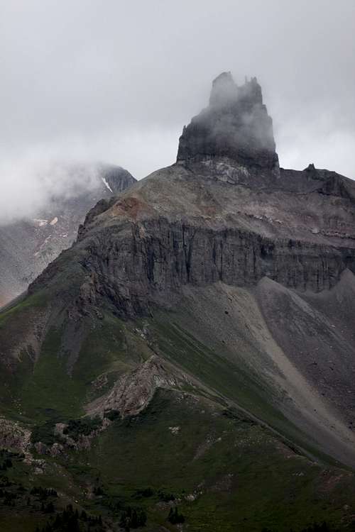 Lizard Head as seen from Black Face summit
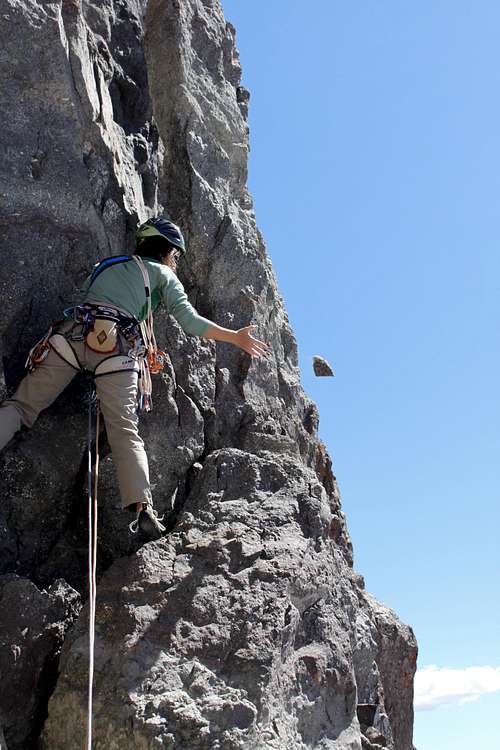 Oops - handhold is out, 1st pitch
Lizard Head is a lofty volcanic pinnacle lying in the fabled San Juan Mountains of southwestern Colorado. It has a number of accolades: it is a 13,000+' volcanic pinnacle (how many of those can you think of?!); it's surrounded by numerous 14,000 ft. peaks; it is in one of the most beautiful regions of the Colorado Rockies; there is no non-technical way to its summit; and it has a storied climbing history. While many know of Lizard Head's existence, to reach its exclusive summit is an honor only earned by a select few. The easiest way up the formation is a 5.8 traditional rock climbing route, and the rock is far from perfect (or even reasonably good, for that matter). Its first ascent was achieved by Albert Ellingwood, quite possibly North America's greatest climber of his time, and was one of the most difficult ascents in the Americas at the time. Modern climbers with nylon ropes, sticky rubber, a good understanding of time-honored crack climbing techniques, and spring-loaded camming devices will have a difficult time imagining ascending the spire without any of these, as Ellingwood did (!!). If you find yourself at the top of this pinnacle at some point in your life, count yourself fortunate for joining a relatively small group, not to mention being in a very special, unique, and beautiful little part of the world.
Many people do not attempt to climb, they simple just hike around Lizard Head on beautiful trails and admire the views. Access is either via Lizard head Trailhead or Cross Mountain Trailhead. Both trailheads end up at the same location and you can do it as a loop (requires two vehicles, or a mountain bike to get you back to your vehicle on highway 145, or 2 mile hike along a highway).
Lizard Head Trail starts at the top of Lizard Head Pass, and interestingly you don't see the peak from this trailhead. This trail climbs over an elongated ridge called Black Face 12,147 feet - the views of Lizard Head from its summit are truly dramatic - see left.
Cross Mountain Trail starts 2 miles southwest of the pass, there is a signed parking lot. You can see Lizard Head from the parking lot. This trail is easier if you wish to climb Lizard Head, and if you wish only for views - you will not be disappointed. As the name of the trail suggest it can also take you to another great summit view of Lizard Head and surrounding mountains - Cross Mountain 12,703 feet.
Guide to the Colorado Mountains with Robert Ormes (sort of a bible of Colorado Mountains) offers 1/2 page description, and it gives this peak more attention when compared with much higher 13rs and 14ers (peaks > 13,000 and 14,000 feet high). "It is one of the most difficult of Colorado summits to reach. However, based on the reports of recent climbing parties, about 50 or more a year, the number of ascents has removed a lot of the loose stuff, and now the rock if fairly sound, especially the upper two pitches. The standard route, pioneered by Albert Ellingwood and Barton Hoag in 1920, begins in a shallow chute on the west face near the southwest corner. The first pitch is the most rotten. Two more pitches take one to the top, with the last pitch being 5.8 in difficulty." The book also mentions another route on the south side, I don't know anyone who has climbed there and would expect rotten conditions since it is not that frequented.
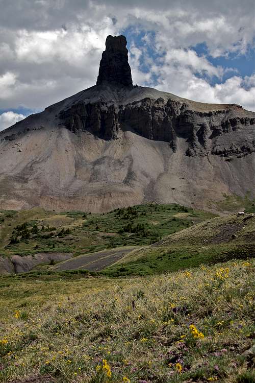
![Lizard Head]() Lizard Head
Lizard Head
![towards the base]() Hiking towards the base of Lizard Head
Lizard Head has an intriguing climbing history. At the time of its first ascent in 1920 by Albert Ellingwood and Barton Hoag, Lizard Head was probably the hardest rock climb then completed in the United States.
Hiking towards the base of Lizard Head
Lizard Head has an intriguing climbing history. At the time of its first ascent in 1920 by Albert Ellingwood and Barton Hoag, Lizard Head was probably the hardest rock climb then completed in the United States.
![Lizard Head - last pitch]() Lizard Head - last pitch
Lizard Head - last pitch
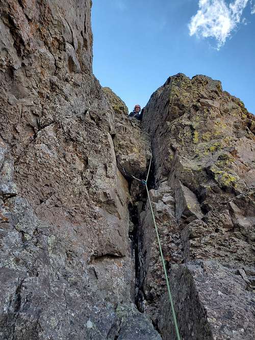
![1st pitch]() 1st pitch
The SW Chimney follows the obvious crack/chimney system on the right side of the south face. This route does NOT follow Ellingwood's original 1920 ascent line.
1st pitch
The SW Chimney follows the obvious crack/chimney system on the right side of the south face. This route does NOT follow Ellingwood's original 1920 ascent line.
![Lizard Head]() Lizard Head
Lizard Head
![Little yoga]() Little yoga
Lizard Head lies fittingly in the 41,193-acre Lizard Head Wilderness, set aside by Congress in 1980 within the San Juan & Uncompahgre National Forests. In addition to Lizard Head, fourteeners Mt. Wilson, Wilson Peak, and El Diente, as well as numerous other 12,000'+ peaks lie within the wilderness area.The following regulations apply to all Wildernesses within the Grand Mesa, Uncompahgre, & Gunnison National Forests (this more or less from the Grand Mesa, Uncompahgre, & Gunnison National Forests website):Motorized equipment and equipment used for mechanical transport is prohibited. This includes the use of motor vehicles, motorboats, motorized equipment, bicycles, hang gliders, wagons, carts, portage wheels, and the landing of aircraft including helicopters. Wheelchairs suitable for indoor use are exempt. Be aware, there is a "Region 2 Wilderness Use Restriction, Special Order" ("Possessing or using a wagon, cart, wheelbarrow, bicycle, or other vehicle (Including “game carts”)") in effect as well, ha ha. Weed Free Feed is required on all national forest lands in the Rocky Mountain Region.A summary of the most applicable rules pertaining specifically to climbers in Lizard Head Wilderness is as follows:• A maximum of 15 people, or a combination of 25 people/livestock, is permitted at one time.• Fires are not permitted within 100 ft. of any lake, stream, or National Forest System trail; above treeline; or within Navajo Basin• Don't shortcut a switchback in a trail. Full regulations specific to Lizard Head Wilderness can be found here.
Little yoga
Lizard Head lies fittingly in the 41,193-acre Lizard Head Wilderness, set aside by Congress in 1980 within the San Juan & Uncompahgre National Forests. In addition to Lizard Head, fourteeners Mt. Wilson, Wilson Peak, and El Diente, as well as numerous other 12,000'+ peaks lie within the wilderness area.The following regulations apply to all Wildernesses within the Grand Mesa, Uncompahgre, & Gunnison National Forests (this more or less from the Grand Mesa, Uncompahgre, & Gunnison National Forests website):Motorized equipment and equipment used for mechanical transport is prohibited. This includes the use of motor vehicles, motorboats, motorized equipment, bicycles, hang gliders, wagons, carts, portage wheels, and the landing of aircraft including helicopters. Wheelchairs suitable for indoor use are exempt. Be aware, there is a "Region 2 Wilderness Use Restriction, Special Order" ("Possessing or using a wagon, cart, wheelbarrow, bicycle, or other vehicle (Including “game carts”)") in effect as well, ha ha. Weed Free Feed is required on all national forest lands in the Rocky Mountain Region.A summary of the most applicable rules pertaining specifically to climbers in Lizard Head Wilderness is as follows:• A maximum of 15 people, or a combination of 25 people/livestock, is permitted at one time.• Fires are not permitted within 100 ft. of any lake, stream, or National Forest System trail; above treeline; or within Navajo Basin• Don't shortcut a switchback in a trail. Full regulations specific to Lizard Head Wilderness can be found here.
History of the climb
 Lizard Head
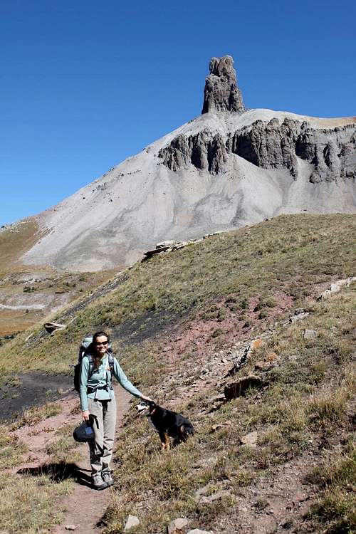 Hiking towards the base of Lizard Head
Armed with three soft iron pitons, hemp rope, and nailed boots, Ellingwood and Hoag made a couple of abortive attempts on cracks near the SW corner before rounding the corner to the west face. Ellingwood reported that "most of the enticing small holds crumbled at the touch, and large masses of the loosely compacted pebbles would topple dangerously at a slight pull".
In spite of the difficulties, they struggled up and placed two of their rustic pitons in the lower cliff, saving one for the higher cliffs.
After spending about a half-hour on top of the summit, Ellingwood and Hoab began an epic descent. Ellingwood's rope became stuck on the lower cliff. As he shook it, a rock came loose and hit him on the top of the head, almost knocking him from the wall. Hoag was also hit by the rockfall but was on secure footing. After more effort, they had to abandon the rope and begin down climbing. Ellingwood reported that Hoag "slipped and, leaving a section of his pants, drifted relentlessly downward until the wall became vertical and then jumped (perhaps 15 feet) to the rocks below. I followed with more caution, regretfully saying goodbye to my rope that has served me well for five good seasons".
Ellingwood and Hoag's climb was well ahead of its time. This is reflected in the comments of Harold G. Wilm, who made the 2nd ascent on June 9, 1929, with Dobson West. Referring to Ellingwood, Wilm noted: At the time, it was considered an impossible feat, and little credence was given to his performance by many who knew the peak. For some time, therefore Dobson West and I had planned a second ascent, chiefly as a proof of his climb, but also as a mountaineering stunt of our own".
Wilm and West did, in fact, confirm the first ascent by retrieving Ellingwood's old rope and finding his old rusty pitons still in place.
Several more ascents of Lizard Head were made during the 1931 joint outing by members of the Colorado and Appalachian Mountain Clubs. Since the early efforts, interest in Lizard Head has waned. The horror stories have taken their toll.
Nevertheless, a few brave souls have persisted. The first winter climb of Lizard Head was made on January 18, 1970, by a strong party from Colorado Springs which consisted of Art Howells, Mike Dudley, Don Doucette, Chuch Behrensmeyer, R.J. Campbell and Fletcher Smith. Although the first 100 feet of the climb had snow on all the holds, they made excellent time and got on and off the summit cone in about four hours.
Information obtained from The San Juan Mountains: A Climbing and Hiking Guide by Robert Rosebrough.
Overview
Lizard Head has been known as Colorado's hardest summit to reach as the easiest route is 5.8+. It stands out as a big pinnacle shooting into the sky. It almost looks like a desert tower except that it's at over 13,000 feet and the rock isn't great. The top 500 feet of Lizard Head is a near-vertical pillar. Heavy erosion leaving what's left of an ancient volcano. That being said, the rock is not Yosemite like. Many that have done it, never return again due to that factor. I would do it again though! It ain't that loose, nor as storied. The summit is the best in Colorado in my opinion. Lizard Head also has a bit of history.There are at least 3 routes in its south face. The standard route is what everyone uses though and the other routes, expect massive amounts of choss. There is potential for new routes if that's your sort of thing. New routes would be steep, loose, run out, and probably require some aid.Elevation: 13,134 feet = 3,997 meters.
Prominence: 1,134 feet = 346 meters
Parent Lineage: Gladstone Peak
Difficulty: 5.8
Colorado Rank: 556
Climb Description - Southwest Chimney 5.8
 Lizard Head - last pitch
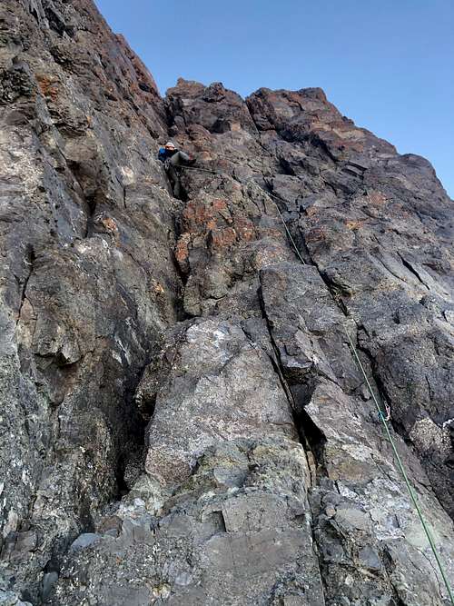 1st pitch
Pitch 1: Climb cracks up a prominent left-facing corner (5.7+) on the right side of the face to a belay at rappel anchors in a prominent pitch. It's best to climb cracks right of the main crack system, before trending up left to the main crack. Pass a narrow ledge about 80 feet up for a possible belay (= intermediate station). This small ledge has pitons for an anchor.
From the ledge, most people move out to the left face and climb delicately up the steep face past a couple of fixed pitons to an airy notch. The whole pitch is 155 feet, and you can split it into two pitches.
Pitch 2: Climb a short easy headwall - class 4 - and then scramble up left across a sloping terrace - class 3 - covered with loose rock to the base of the upper headwall. This pitch is very easy, but very loose.
Pitch 3: Climb 20 feet up a chimney, clip a piton up left, then climb to a small roof/overhang (5.8) protected by a #4 camalot in the crack right of the roof = crux. A couple of strenuous moves are needed to get over the overhang before the terrain eases up. Continue up the easy chimney above or face climb up left up a steep groove (5.5). Look for belay and rappel anchors. This pitch has mostly solid rock. Scramble from here to the summit. This section is not difficult, but it is loose - pay attention to your footing.
Paulinds recounts a variation of the last pitch (thanks, Paul!):
"
A variation to the third lead
A variation to the third lead
Before resorting to an offered shoulder stand, I went around the corner to the right to explore the south face. There I was able to continue to the summit by way of a ramp, traversing the face to the left and then continuing up another to the right. It seemed straightforward at maybe 5.6-7 but poorly protected with the gear we had.
Thanks to the generosity of a great friend and climber, he let me lead the whole thing...my first. I wish I could still share the memory of that day with him."
Descent requires at least as much caution as the ascent. Make two double rope rappels down the route. Be careful when pulling the ropes, both to avoid getting your ropes stuck and to avoid getting hit by loose rocks. If you have 70 meter rope, that is sufficient for descent and probably a better option (less chance of getting ropes stuck), but you will have to down climb the class 3 section.
Getting There
The most straightforward access to the spire is via Cross Mountain Trailhead, approximately 2 miles west of Lizard Head Pass, and 17 1/2 miles from Telluride. From Telluride, go to the state route 145 north/south split. Go south (L) along state route 145 (San Juan Skyway) for 14.0 miles (past Lizard Head Pass) to Cross Mountain Trailhead. From the southwest: from Cortez, go to the state route 145 junction and follow 145 north for about 57 miles to the same location. Hike the Cross Mountain trail (#637) approximately 3 miles to its intersection with the Lizard Head trail, at the base of the formation. Alternately, it is possible to get to Lizard Head from the trailhead at Lizard Head Pass (Lizard Head Interpretive Site); the Lizard Head trail (#505) goes to the base of the ridge, then follows it west to the base of the pinnacle.Take the talus cone to the formation's base, using the faint trail if you can find it. Go to the obvious corner marking the start of the standard route.National Geographic's 'Trails Illustrated Map' to Telluride, Silverton, Ouray, & Lake City is an excellent topographic map to the area.
Red Tape
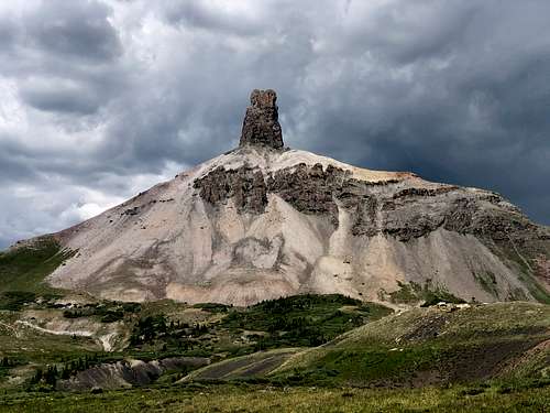 Lizard Head
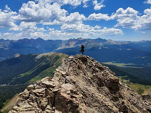 Little yoga
When To Climb
July to early September is the main season for climbing Lizard Head Peak. The snow is gone. That being said, take my advice and get a late start. The route is in the shade in the morning and is bitter cold. Some have got frostbite in the summer. You don't want to get too late of a start though. Make sure your off the summit by 11 or 12 at the latest as this would be one nasty place to be with lightning.Winter on Lizard Head Peak is more of a challenge if doing it in the summer is not hard enough. It involves a large dose of suffering. Climbing in double boots and gloves is a must making the climb feel a bit harder than 5.8. No ice screws needed as there was no ice just snow-covered rock. The summit has been one of my favorite experiences in the winter in CO. That being said, I only know of one or maybe two parties climbing it in the winter in recorded history. It's a bit more serious but well worth the effort!Camping
Telluride area offers several campgrounds:
- Alta Lakes Campground: dispersed primitive camping in an alpine setting, no reservations: first-come-first-serve basis, no fee
- Matterhorn Campground: developed campground close to Colorado Highway 145 near Telluride, 28 sites, fee, can make reservations.
- Priest Lake camping area: no designated camping sites, dispersed camping, no services, no fee, vault toilet.
- Sunshine Campground: no reservation needed (first-come-first-serve basis), fee, 15 sites, composting toilets
- Woods Lake Campground: situated in a dense aspen forest, 41 sites, fee, no reservations (first come - first serve basis).
Additional Resources
- Lizard Head on 13ers.com
- Lizard Head on Mountain Project
- Lizard Head on Wikipedia
- Lizard Head trails description great description of trails surrounding Lizard Head
- Denver Post: Lizard Head is one formidable beast
- Lizard Head Wilderness
- Route Description for Lizard Head by Stewart Green
- Lizard Head on List of John
Diggler - Jun 28, 2012 7:11 pm - Voted 4/10
rap' anchor workNot sure if there are other options, but the rap' anchor we used (it puts you ~30' to the R of the standard route P3 start) totally sucked- it held for us to get down, but 2 attempts to pull our ropes were fruitless- I ended up prusiking back up to the anchor TWICE to try to free the lines, but each time, it was still totally impossible to pull them. We ended up leaving a rope left by an earlier party that I'd hoped to return to its owner, & just doing a single-rope rap' off of it (because it was impossible to free our own ropes). Extending the anchor over a prominent edge just below it with some additional chains/quick links, & using a dedicated rap' ring (instead of threading the ropes through 2 chain links would quite possibly do the trick). If a future ascent party familiar with anchor set-up could bring some additional hardware & do some modification, that would be a great community service.
paulinds@earthlink.net - Aug 19, 2020 1:56 pm - Hasn't voted
A variation to the third leadIn late June 1968, Cleve McCarty and I climbed Lizard Head via a variation of the third lead on the south side of the summit block. Using a 150 ft. rope, we split the southwest chimney lead in two. We were unable to protect or climb the short overhang/lie back to start the third lead. Before resorting to an offered shoulder stand, I went around the corner to the right to explore the south face. There I was able to continue to the summit by way of a ramp, traversing the face to the left and then continuing up another to the right. It seemed straightforward at maybe 5.6-7 but poorly protected with the gear we had. Thanks to the generosity of a great friend and climber, he let me lead the whole thing...my first. I wish I could still share the memory of that day with him.
Diggler - Sep 9, 2020 2:14 pm - Voted 4/10
Re: A variation to the third leadThanks, Paul. I included the last part of your route description on the page. I'm glad you had that day with your partner- my best days have been in the hills with friends & loved ones, some of whom are no longer here. I can relate.