
|
|
Mountain/Rock |
|---|---|
|
|
46.33897°N / 9.63902°E |
|
|
Trad Climbing, Sport Climbing, Scrambling |
|
|
Spring, Summer, Fall |
|
|
8159 ft / 2487 m |
|
|
Overview
Spazzacaldeira is the name of the ridge directly west of the Albigna reservoir, just to the north of the Al Gal. It offers a multitude of alpine-sport routes across its eastern face and the north-east ridge is a well known classic in the area. Because of the generally well bolted nature of the routes and the incredibly easy access via the nearby cable car station, Spazzacaldeira can attract a large number of climbers. Most of them will be aiming for the summit pinnacle, the famous Fiamma, a striking summit spire seen on many local postcards.The north-east ridge is by far the most popular route on the mountain. An enjoyable and somewhat more 'alpine' alternative is the north ridge which is a nice short climb graded UIAA IV devoid of any bolts or pegs.
With an easy descent on its southern side and a mere five minutes walk from the cablecar station at the foot of the Albigna dam, Spazzacaldeira is the number one climbers attraction in the Albigna area. While the NE ridge and especially the Fiamma are local classics, an exploration of the somewhat harder to reach peaks in the Albigna area is very worthwhile and shouldn't be overlooked either.
 The popular NE-ridge.
Getting There
Getting there couldn't be easier; there is a cablecar that leaves from the small hamlet of Pranzaira a few kilometers below the Maloja pass. A return ticket costs 18 CHF (about 12 Euros) and takes you up to the base of the Albigna dam in approximately 15 minutes. From there it's an easy 5 minutes walk to the start of most of the routes, virtually all of which are easily visible from just above the cablecar station. For those who like to steer clear of such mechanical transportation, there is a well marked footpath which leads to the foot of the dam as well. It starts on the right side of the road just above the cablecar station in Pranzaira. The walk-in takes about 2 - 3 hours.For those staying overnight there is the comfortable Albigna hut located about an hours walk from the cablecar station. Alternatively the area offers some excellent bivouac spots, with the station itself being rather cosy.
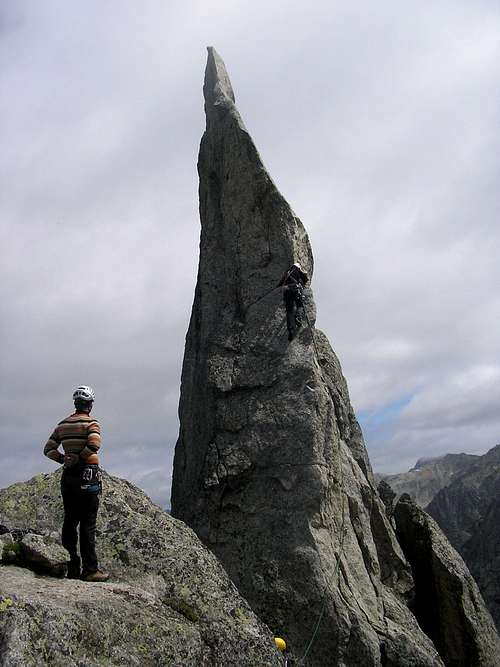 The Fiamma
Red Tape
No red tape. Though keep in mind that bivouacing is officialy prohibited. Generally you won't run into much trouble if you keep a low profile. There are some very nice spots to bivvy in the rubble field you pass through on your way down from the Spazzacaldeira.Routes
There are many routes that can be climbed on the Spazzacaldeira. Below is an overview and in the picture you can find those routes indicated which have been described here on Summitpost.1) Via Leni; 5c+
2) Tiramisu; 6b
3) Via Lasciami-li; 6a
4) NE - Ridge; 4a+
5) Dente per Dente; 6a
6) Via Felici; 6a
7) Nasigoreng; 6a
8) Benno; 6b
9) Excalibur; 6c
10) Steinfresser; 6a+
11) Nuova via per Claudia; 6a+
12) N - Ridge; IV
13) S - Ridge (descent route); 1 section of II/III
Fiamma; 5c+
Dente; 6a+
ENLARGE PICTURE FOR ROUTE OVERVIEW
Red = NE - Ridge
Green = Dente per Dente
Blue = Via Felici
Yellow = N - Ridge
Purple = descent route
F = Fiamma
D = Dente

Camping
About an hours walk from the Albigna cablecar station is the Albigna hut which offers good food and accomodation and is nicely located. Alternatively the area around the cablecar station offers some good places for a biouvac, with the station itself being the most cosy. For those who prefer a little less creature comfort, a short walk along the path to the Al Gal, south west of the Albigna lake, takes you past a very large overhanging boulder which makes a perfect bivouac spot. Just a few ideas to get you started!The nearest campsite in the valley is located just outside of the small town of Vicosoprano and is called camping Mulina. This campsite is less then five minutes by car from the Cablecar station at Pranzaira.
Guidebooks and maps.
Schweiz Plaisir Sud.SAC Fuhrer 'Sudlicher Bergell'.
Map: Swiss 1:25000 #1276 'Val Bregaglia'.
External Links
The Albigna HutCamping Mulina