
-
 14087 Hits
-
 81.83% Score
-
 14 Votes
|
|
Mountain/Rock |
|---|---|
|
|
46.29204°N / 9.58042°E |
|
|
Lombardia |
|
|
Mountaineering |
|
|
Summer |
|
|
10292 ft / 3137 m |
|
|
Overview

Punta Torelli is the second for elevation after the Punta S.Anna (3169m) on the ridge that constitutes an important topographic part of Val Masino Alps (Bergell).
Punta Torelli is less interesting for climbing, if compared to the near mountains, but hosts some fine routes on perfect granite, on both the Italian sides.
The spire rising above the Rifugio Gianetti, and named "Dente della Vecchia" is part of this mountain and hosts some rocky routes on its south side.
The name "Torelli" was given, by the first climbers, in honour of the senator Luigi Torelli, former president of the Valtellina section of Italian Alpin Club.
The nearness to the Rifugio Gianetti, and the easy approach, make the normal route a funny occasion for beginners and to enjoy the impressive panorama.
![Summit list from ref.Gianetti.]()
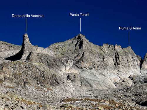
Dente della Vecchia, Punta Torelli and Punta S.Anna seen from ref.Gianetti.
The approach from Swiss is quite long: the mountain is situated all in Italian territory.
The best way to get it is overriding the Passo della Trubinasca (2701m - two hours from Cab Sasc Furà): this route allows to "discover" the west side.
Another way is the crossing of the Passo Porcellizzo (2862m), that connects the Val Codera to the Val Porcellizzo and also to reach the refuge Gianetti and the East side.
Cab Sasc Fura'is placed in Val Bondasca. (600m EE - Two hours from Laret).
From Italy:
WEST SIDE (Val Codera)
Punta Torelli is placed at the head of Val Codera.
A bivouac called Pedroni del Pra',permits to take a break during this very long approach. From Novate Mezzola in 6/7 hours.
To Novate Mezzola by car on road SS36.
Otherwise by busses or trains from Milan and Sondrio.
EAST SIDE (Val Porcellizzo-Val Masino)
The best way and confortable.
The refuge Gianetti, is the local hut: good path from "Bagni del Masino" in 3/4 hours.
"Bagni del Masino" is the last house group of the valley. Reachable by cars or busses from Ardenno in Valtellina,road SP404.
Trains and busses from Milan and Sondrio.
G.Cett,F.Besta,C.Gerini,P.Botterini,C.Bonadei,Cambray,Gigny.
Wrongly ascent,convinced in the fog to climb the Pizzo Badile!!! 29/08/1875
SOUTH WALL.A.Radaelli,G.Fiorelli. 31/06/1906
NORTH RIDGE.R.Balabio,G.Scotti. 11/08/1909
SOUTH RIDGE-NORMAL ROUTE: From ref.Gianetti, 1.30/2 hours.(I°/II° F+)
NORTH RIDGE: From Punta S.Anna, very interesting.(III°/IV°)
SOUTH EAST WALL: (via SELEN) From ref.Gianetti, (5c/6a obbl. - 325m - 10 pitches) (Giuseppe Foscili,Lorenzo Lanfranchi,Luca Maspes,Carlo Micheli - 08/2000)
SOUTH EAST SPUR: (via MAURI/FIORELLI) From ref.Gianetti, 4,30 hours.(IV°/V°)(300m)
Dente della Vecchia:
Via "FUNGHI e VENTO": From ref.Gianetti, (70m 6c/A1)
Via "POLIDENT": From ref.Gianetti, (280 m 6a/5c obb)
From Bondo-Laret 2 hours(EE).
Refuge Gianetti 2534m - CAI sez. Milano.92 places / 12 in the winter room
open from 01 July to 15 September.
Tel.0039/0342.645161. Warden tel.0039/0342.641068.
From "Bagni del Masino" 3/4 hours(E).
Bivouac Pedroni del Prà 2600m - CAI Novate Mezzola.9 places,always open.
From Novate Mezzola 6/7 hours(E).
-A.Bonacossa/G.Rossi.Masino Bregaglia Disgrazia."Guide dei Monti d'Italia" vol.II TCI 1975
-Miotti/Gogna."Dal Pizzo Badile al Bernina".Zanichelli - 1986
-"Masino-Bregaglia-Disgrazia" G.Maspes and G.Miotti "Guida delle Guide"
Maps:
-Kompass - Chiavenna-Val Bregaglia 92/93 1/50000
-Swiss topographic maps: Val Bregaglia # 1276 and Sciora # 1296 1/50000
Links:
www.metoswiss.ch
www.Meteorisk.com
www.swisswebcams.ch
www.ARPAlombardia.com
This summit is the union point of 3 watersheds dividing the Val Bondasca on the North side (Switzerland), the Val Codera and the Val Porcellizzo (Italy).
This summit is also a very panoramic place for its nearness to Pizzo Badile and its west side.
This summit is also a very panoramic place for its nearness to Pizzo Badile and its west side.
Punta Torelli is less interesting for climbing, if compared to the near mountains, but hosts some fine routes on perfect granite, on both the Italian sides.
The spire rising above the Rifugio Gianetti, and named "Dente della Vecchia" is part of this mountain and hosts some rocky routes on its south side.
The name "Torelli" was given, by the first climbers, in honour of the senator Luigi Torelli, former president of the Valtellina section of Italian Alpin Club.
The nearness to the Rifugio Gianetti, and the easy approach, make the normal route a funny occasion for beginners and to enjoy the impressive panorama.
Dente della Vecchia, Punta Torelli and Punta S.Anna seen from ref.Gianetti.
Get here:
From Swiss:The approach from Swiss is quite long: the mountain is situated all in Italian territory.
The best way to get it is overriding the Passo della Trubinasca (2701m - two hours from Cab Sasc Furà): this route allows to "discover" the west side.
Another way is the crossing of the Passo Porcellizzo (2862m), that connects the Val Codera to the Val Porcellizzo and also to reach the refuge Gianetti and the East side.
Cab Sasc Fura'is placed in Val Bondasca. (600m EE - Two hours from Laret).
From Italy:
WEST SIDE (Val Codera)
Punta Torelli is placed at the head of Val Codera.
A bivouac called Pedroni del Pra',permits to take a break during this very long approach. From Novate Mezzola in 6/7 hours.
To Novate Mezzola by car on road SS36.
Otherwise by busses or trains from Milan and Sondrio.
EAST SIDE (Val Porcellizzo-Val Masino)
The best way and confortable.
The refuge Gianetti, is the local hut: good path from "Bagni del Masino" in 3/4 hours.
"Bagni del Masino" is the last house group of the valley. Reachable by cars or busses from Ardenno in Valtellina,road SP404.
Trains and busses from Milan and Sondrio.
 |  |  |
History
FIRST ASCENT.G.Cett,F.Besta,C.Gerini,P.Botterini,C.Bonadei,Cambray,Gigny.
Wrongly ascent,convinced in the fog to climb the Pizzo Badile!!! 29/08/1875
SOUTH WALL.A.Radaelli,G.Fiorelli. 31/06/1906
NORTH RIDGE.R.Balabio,G.Scotti. 11/08/1909
Routes
Punta Torelli:SOUTH RIDGE-NORMAL ROUTE: From ref.Gianetti, 1.30/2 hours.(I°/II° F+)
NORTH RIDGE: From Punta S.Anna, very interesting.(III°/IV°)
SOUTH EAST WALL: (via SELEN) From ref.Gianetti, (5c/6a obbl. - 325m - 10 pitches) (Giuseppe Foscili,Lorenzo Lanfranchi,Luca Maspes,Carlo Micheli - 08/2000)
SOUTH EAST SPUR: (via MAURI/FIORELLI) From ref.Gianetti, 4,30 hours.(IV°/V°)(300m)
Dente della Vecchia:
Via "FUNGHI e VENTO": From ref.Gianetti, (70m 6c/A1)
Via "POLIDENT": From ref.Gianetti, (280 m 6a/5c obb)
Accomodations
Refuge Sasc Furà 1904m - CAS sez. Bregaglia.50 places,open from 01 July to 15 September.Tel 0041/818221252.From Bondo-Laret 2 hours(EE).
Refuge Gianetti 2534m - CAI sez. Milano.92 places / 12 in the winter room
open from 01 July to 15 September.
Tel.0039/0342.645161. Warden tel.0039/0342.641068.
From "Bagni del Masino" 3/4 hours(E).
Bivouac Pedroni del Prà 2600m - CAI Novate Mezzola.9 places,always open.
From Novate Mezzola 6/7 hours(E).
Books Maps and Links
Books:-A.Bonacossa/G.Rossi.Masino Bregaglia Disgrazia."Guide dei Monti d'Italia" vol.II TCI 1975
-Miotti/Gogna."Dal Pizzo Badile al Bernina".Zanichelli - 1986
-"Masino-Bregaglia-Disgrazia" G.Maspes and G.Miotti "Guida delle Guide"
Maps:
-Kompass - Chiavenna-Val Bregaglia 92/93 1/50000
-Swiss topographic maps: Val Bregaglia # 1276 and Sciora # 1296 1/50000
Links:
www.metoswiss.ch
www.Meteorisk.com
www.swisswebcams.ch
www.ARPAlombardia.com