
|
|
Mountain/Rock |
|---|---|
|
|
53.10629°N / 4.00383°W |
|
|
Gwynedd and Conwy |
|
|
Hiking, Mountaineering, Trad Climbing, Bouldering, Mixed, Scrambling |
|
|
Spring, Summer, Fall, Winter |
|
|
3261 ft / 994 m |
|
|
Overview
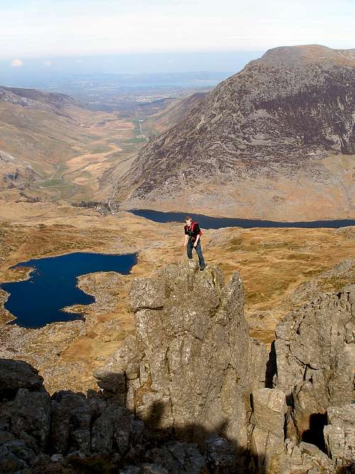
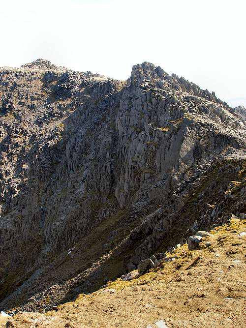
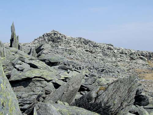
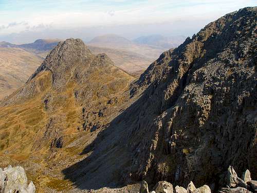
Glyder Fach (SH 656 583) is the smaller neighbour of its sister peak Glyder Fawr (SH 542 579). At 995m it is the second highest peak in the Glyderau and is also one of the most impressive. During the last ice age the summit of the mountain protruded above the ice sheet as a nunatak exposed to a harsh Arctic climate that heavily weathered its bedrock. This weathering led to the summit becoming covered by a myriad of broken stone and boulders capped by several large tors, from one of which the famous cantilever stone protrudes. One of these tors is the famous Castell y Gwynt (SH 654 581; translates as Castle of the Wind) which is situated to the west, sitting astride a broad ridge that connects the two Glyderau. Not only does this tor offer a superb foreground to photographs of Snowdon it also presents some hugely entertaining bouldering set within a dramatic location. Although when viewed from Snowdon the mountain appears unimpressive and rounded, its northern slopes consist of a series of steep cliffs riddled with deep gullies and jutting buttresses. These cliffs offer a range of climbs and scrambles, probably the most popular of which is Bristly Ridge, a fine Grade 1 scramble with plenty of exposure that connects Glyder Fach with its northern neighbour Tryfan (SH 663 593).  Castell y Gwynt (Photo by vancouver islander) Castell y Gwynt (Photo by vancouver islander) |
Routes

Main Gully (Grade 1, but probably Grade 2 - See Additions & Corrections) A quality scramble through a gloomy gully that isn’t really a gully at all, but a rocky depression between the buttresses of the Chasm Face and the protruding bulm of the main gully ridge. Main Gully Ridge (Grade 2 or 3) This blunt ridge that rises above Alphabet Slab provides the most direct line of ascending Main Cliff. The scrambling is nicely exposed and technical, though the difficult start can be avoided if necessary. East Gully Ridge (Grade 2 or 3) This ridge, which overlooks East Gully makes an excellent scramble. The difficult first section is completely avoided by a traverse from Alphabet Slab, while the intricacies of the middle section can be, if necessity dictates, be flanked on the gully side. Good belays can be found at intervals. Shark Buttress (Grade 3) This fun but wandering line seeks out the best from the central area of terraced buttress. Complex route-finding and surprising escapes add to the anxiety and interest. Dolmen Ridge (Grade 3) The curving line of Central Gully defines the right-hand side of the huge face taken by Shark Buttress. On the left side of the gully, at about half height, stands the compact, triangular crag of Dolmen Buttress. This excellent scramble crosses Central Gully to ascend the right edge of Dolmen Buttress, then uses the left-bounding ridge of the gully to gain the Glyder Fach plateau just a few metres from the summit tors. |

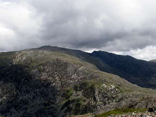
The Glyders from Clogwyn y Person, Snowdon. The mountains from left to right: Y Garn (947m), Pen-yr-Ole Wen (978m; background), Glyder Fawr (1,000m), Glyder Fach (994m), Crib Goch (923m) and Moel Siabod (872m; background)
(Photo by Nanuls)
(Photo by Nanuls)
Rock ClimbingGlyder Fach is among Snowdonia’s most popular mountains for climbers and the mountain's crags are comprehensively described in the Climbers’ Club’s Ogwen guide. Supplementing this detailed guide are a number of general guides, which will perhaps be more suitable for the occasional visitor; these are, in order of date published:
Rock Climbing in North Wales by Paul Williams (Constable) For those interested in such things, the first guidebook to North Wales rock, Rock Climbing in the British Isles, Volume 2 Wales and Ireland, was published way back in 1895 by W.P. Haskett Smith. This was followed by a more ‘modern’ incarnation of the guidebook in 1906 in the form of G.D. and A.P. Abraham’s Rock Climbing in North Wales. The first dedicated guide to climbing in the Ogwen Valley, Climbing in the Ogwen District, was written by J.M. Archer-Thompson and published by the Climbers’ Club’s in 1910. It was the Club’s second ever guide. The following section provides details of the rock climbing offered by the mountain’s crags. As is the case throughout the UK, rock climbs on Glyder Fawr are graded using the combined adjectival and technical grading systems. To get an idea of what this means, Rockfax have a frankly excellent table plus explanation on their website. |
|
Gamma (S 155ft/47m) A delicate line up the centre of the Alphabet Slab. A diagonal chimney/crack line is the prime feature of this slab – Beta (diff) and Alpha (VS) climb the slab on the left, whilst Delta (V Diff) lies right of Gamma. The start is below the chimney/crack on a subsidiary terrace, and climbs 14m up a shallow groove, and continues until a horizontal traverse left leads to a stance and belay on the edge of Beta. It then climbs a further 24m left into a narrow crack, and finishes 9m up a wall on small holds to a tricky finish. Chasm Route (V Diff 265ft/80m) A deep narrow fissure just to the left of Main Gully gives an interesting climb. The start is directly below the Chasm at a rocky rib, 9m to the right of The Capstan. Lot’s Wife (VS 110ft/33m) A fine and enjoyable climb taking the face of the pillar between the Direct Route and Chasm Route, and starts at the foot of the Chasm proper, or slightly lower. Lots Groove (HVS 110ft/33m) Although this route is at the lower end of its grade, it’s a superb pitch, both delicate and strenuous with good protection. The route shares the same start as Lot’s Wife. The Direct Route (HS 300ft/91m) An excellent traditional expedition which, when combined with the Rectangular Excursion (avoiding Gibson’s Chimney, VS) and the Winter Finish, has only one short difficult section – the Hand Traverse. The start is located at the Capstan on the left of the rib. Slab Climb by the Spiral Variant (V Diff 235ft/71m) A very enjoyable route taking a line up the buttress left of the Direct Route, the start is located at the Capstan. Oblique Buttress (S 200ft/59m) A fine climb taking the left hand side of the East Buttress. Start from the foot of the lowest rocks some 37m left of the Luncheon Stone, where a rib runs up to a prominent crack. |
|
Hawk’s Nest Buttress (S 185ft/56m) This hugely enjoyable route lies on the West Buttress and climbs a narrow pillar of rock, the left edge of which forms a prominent knife-edged arête 46m right of East Gully. The route is best approached by a traverse right from the top of Alphabet Slab and starts below the arête on the terrace. Hawks Nest Arête (VS 120ft/36m) An excellent route providing some of the best climbing on the crag. The start is located on the left hand side of the terrace some 6m left of Hawk’s Nest Buttress. Winter Climbing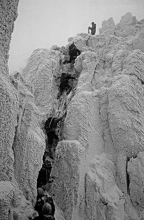 Climbing on Bristly Ridge (photo by sadeik) Climbing on Bristly Ridge (photo by sadeik)Bristly Ridge (Grade II 200m) This classic summer scramble turns into a quality and somewhat more strenuous winter route when covered in snow and ice, with some great situations on the upper pinnacles. Main Gully (Grade II 260m) The lower 120m of the climb holds the most interest; thereafter a broad depression leads easily onto the summit plateau. The steep icy pitches of east gully, some 100m to the right are skirted in favour of a devious but easier approach. East Gully (Grade III/IV) This is the true, direct start to main gully, and is very steep. The amount of ice in the chimney varies greatly, but when it is in condition provides a fine steep ice-pitch. Central Gully (Grade II/III 250m) A fine climb, slightly flawed by the width if the gully and all the possible variation. The first 100m provides the technical interest if taken direct, but the faint hearted will find soft options just to the right. Plaques Route (Grade II/III 250m) A pleasant, if rather vague climb which uses the iced slabs to gain access to broken snow slopes. A long haul finds the plateau above. Western Gully (Grade II 130m) To the right, but before the face begins to swing round there is a vaguer and indistinguishable line which becomes more so as it rises. However the initial stages provide a snow groove of fair interest. It runs parallel to the Gully of the Winds route (below) some 30m away. It is possible to start directly below the line or traverse in from higher up to the right just below a line of rock walls. Gully of the Winds (Grade I 75m) A buttress looms at the back of the cwm as things begin to steepen, so veer up the shallow corner to the left, keeping one hand on the rock to the right all the way! Col Gully (Grade I 70m) The slope and gully direct to the col at the rear of the cwm provide a straightforward route to the plateau. |
Mountain Conditions
This section displays the mountain conditions for Snowdonia, of which Glyder Fach is part. Click on the widget for maps and further information. This Snowdonia weather forecast is generated by the Met Office Weather Widget |
When to Climb
Glyder Fach can be climbed at anytime of the year from Glyder Fawr and Pen y Gwryd or via the Bristly Ridge, however in poor conditions some routs are best avoided particularly if visibility makes route finding difficult. Of course this all depends on ones ability as a mountaineer/climber, and what might be comfortable for some may seem daunting for others. It is worth noting that some areas of rock, particularly those that have been heavily abraded, can become very greasy when wet. If your lucky enough to climb the mountain in winter conditions then an ice axe (or ice axes on the harder routes), crampons, a helmet, a rope and a descent winter rack (if going for a more serious route) are all essential. |
Getting There
 Glyders from Snowdon (Photo by Nanuls) Glyders from Snowdon (Photo by Nanuls)If approaching from the north or west, e.g. from Liverpool or Hollyhead, turn off the A55 and onto the A5 at the large junction (SH 593 694) that sign posts for Bethesda and follow the road until Llyn Ogwen where parking is available. If coming from the east, take the A5 through Bettws y Coed (SH 798 599) and Capel Curig (SH 719 580) which will take you directly to the base of the mountain. If driving from the south, take the A470 through Blaenau Ffestiniog (SH 700 458) to Bettws y Coed, and turn off onto the A5 towards Bethesda which will take you the same way as if coming from the east. There is plenty of parking along the A5 near Tryfan, some of which you have to pay for, some of which you don't. My advice is to never bother with the official car parks and just park along the roadside. There is a wide 'pavement' type verge on the southern side of the road that can easily accommodate the width of a car or minibus, and is completely free and never full (even on bank holidays). It also allows you to park even closer to the base of the mountain and the start of the path. There is also parking to the south at Pen y Gwryd and Pen y Pass. Pen y Pass car park (SH 647 555) is located at the zenith of the Pass of Llanberis, and can be reached easily by road on the A4086 that runs between Llanberis (SH 582 598) and Capel Curig (SH 719 580). Owing to the sheer number of routes that start there the Pen y Pass car park often fills up quickly so if you want to park there a very early start is recommended. There is also parking and a good starting point around 1.5km to the east along the roadside near the Pen-y-Gwryd Hotel (SH 660 558). Do not park in the hotels car park as this is for guests only. |
Red Tape and Access
No red tape here! For climbers, hill walkers and mountaineers, the British Mountaineering Council (BMC) runs a Regional Access Database, which holds mountain/crag specific information on matters of conservation and access, including issues such as nesting restrictions, nature designations and preferred parking. If you are in any doubt about any particular access arrangement, or need to report an incident, you should contact your local BMC Access Representative or the BMC Access Officers for Wales: Elfyn Jones. |
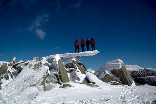
 Castell y Gwynt Castell y Gwynt(Photo by Nanuls) | 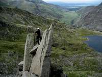 Shark Buttress Shark Buttress(Photo by mountainmanjohn) |  The summit The summit(Photo by Nanuls) |
Camping and Accommodation
There is plenty of camping in close proximity to Glyder Fach: Gwern Gof Uchaf Campsite, Gwern Gôf Isaf Campsite and Bunkhouse and Garth Farm Campsite can all be found nearby just to the east. There are also a number of YHA hostels in the area, the nearest of which is Idwal Cottage, a short walk from the base of the mountain. The Plas y Brenin National Mountain Centre in Capel Curig also has a bunk house, and has its own indoor climbing wall if you still feel energetic after your day on the mountain. Also the nearby towns of Capel Curig, Bettws y Coed and Bethesda all have various hotels, hostels, B&Bs and campsites. |
Maps
|
| Navigation Maps OS 1:25k Explorer Series OL 17 Snowdon/Yr Wyddfa OS 1:50k Landranger Series 115 Snowdon/Yr Wyddfa Harvey Map Services 1:25k: Snowdonia North: Snowdon, Glyders, Carnedds Harvey Map Services/BMC 1: 40k British Mountain Map: Snowdonia North Road Maps |
Guidebooks


External Links
 Glyder Fach (Photo by Nanuls) Glyder Fach (Photo by Nanuls)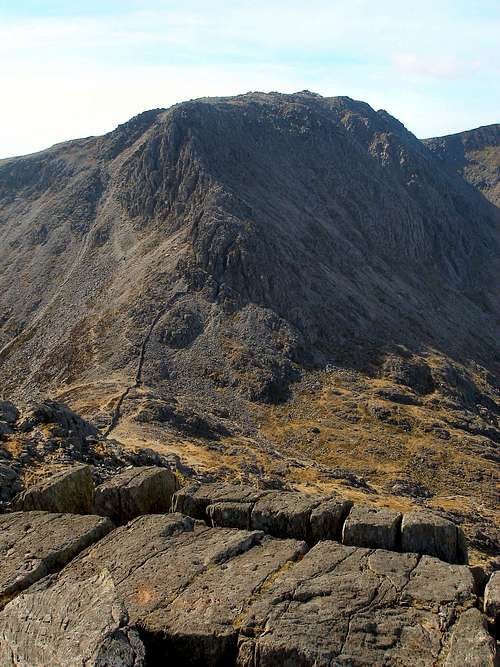 Glyder Fach and Bristly Ridge (Photo by Nanuls) Glyder Fach and Bristly Ridge (Photo by Nanuls) Glyder Fach (Photo by Nanuls) Glyder Fach (Photo by Nanuls)Government Bodies and Official Organisations Snowdonia National Park Authority Association of National Park Authorities Royal Commission on Ancient & Historical Monuments in Wales Hiking, Climbing and Mountaineering Organisations and Companies British Mountaineering Council Plas y Brenin National Mountain Centre Weather Tourist Information North Wales Tourism Partnership Local Information from Gwynedd.com Local Information from Snowdonia Wales Net Travel Welsh Public Transport Information Accommodation Youth Hostel Association in Wales Maps and Guidebooks Cordee Travel and Adventure Sports Bookshop Wildlife and Conservation |
georgen - Apr 15, 2009 7:00 am - Voted 10/10
Main Gully difficultyThis is not grade 1 scramble.Grade 2 with loose rock on places.The crux is chockstone,to overcome it one move is Mod.
Nanuls - Apr 15, 2009 8:31 am - Hasn't voted
Re: Main Gully difficultyHi there, according to Steve Ashton it is Grade 1, but I will change grade on this page to reflect you opinion. Cheers Dan
otaylor - Jul 12, 2009 6:29 am - Hasn't voted
i am in agreement!This route is certainly not a grade 1!! The guide book does say that it is a Grade 1, so we did not take a rope, and this made it incredibly difficult and dangerous. I think it is possible erosion has occured since the guide book was written (it was back in the 80's!) meaning that vital holds were missing. Furthermore, there is no way out once you are in the gully!
Nanuls - Jul 12, 2009 12:24 pm - Hasn't voted
Re: i am in agreement!Wow, that's not good. Thanks for your comment.