
|
|
Mountain/Rock |
|---|---|
|
|
44.18890°N / 113.8096°W |
|
|
11473 ft / 3497 m |
|
|
Overview
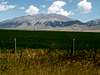
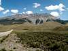
Horseshoe Mountain sits in the heart of the rugged Lost River Range in central Idaho.
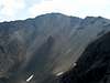
Horseshoe Mountain is a massive pile of precipitous talus and unpleasant scree. The summit region is extremely steep and especially impressive when viewed from the east. Its western face is made up of a series of complicated, yet beautiful, series of ridges and towers. Horseshoe Mountain's northwest face sits at the head of a an unnamed drainage and consists of an 1,800 foot wall of loose, impassable rock.
Geographically Horseshoe Mountain sits in the exact center of the Lost River Spine, just to the south of Doublespring Pass. Just as many other obscure, yet impressive mountains in the Lost River Range, Horseshoe Peak is seldomly visited.
Thousands of years ago the Lost River Range was located beneath an inland sea. This is evinced along the slopes of Horseshoe Mountain as the remains of ancient sea critters have left their marks in a remarkable display of fossilization on the barren slopes of the peak.
It has been reported that Rick Baugher, a famous Idaho mountain pioneer, made the first ascent in 1993 and placed a horseshoe, rock cairn, and summit register in the form of a peanut box, which is now empty, on the summit, therefore giving the name Horseshoe Mountain. However, during my exploration of this peak and its subsidary ridges, I discovered a dishoveled USGS marger scattered in the scree slopes marking a 1924 ascent, so the it remains a question to whom really summited it first.
 |  |  |  |  |
Getting There
Primary access to Horseshoe Mountain is via the Doublespring Pass Road from US Highway 93. From Arco, travel 45.8 miles north, or from Challis, travel 31.4 miles south to the Doublespring Pass Road that leads toward the east.To access the West Ridge Route, drive on this improved gravel road for about 5.5 miles, or to the roughly to the point where the road crosses the 7,400' contour line on the TOPO maps.
To access the East Ridge Route, drive over Doublespring Pass and turn onto Horsehaven Pass Road keeping right at two forks at .3 miles, and 1.9 miles, respecively. At this point, a four-wheel drive vehicle is required. Continue 8 slow more miles until reaching Mahogany Creek Road. Follow this short and rough road for access to the East Ridge Route.
 |  |  |  |
West Ridge Route
This route, albeit short in mileage, is a great adventure, leading through thick brush, pleasent forests, horrible scree, and difficult scrambling.Requirements For Climbing Horseshoe Mountain's West Ridge Route
Route Stats
From the 7,400' contour line at Doublespring Pass Road, head toward the intimidating lower slopes of the west ridge that is covered in very thick brush. Aim for an indent (somewhat of a gully) that runs southeast and quickly turns east and heads into the forest. The brush in the indent is not quite as thick as other areas in this mini-forest. If you come across cleared spots in the brush that run parallel along the base of the mountain, continue past them. Taking one of these clearings will leave you lost as they mix and zig-zag eventually leading now where.
At about 8,200', the terrain changes abruptly to an evergreen forest with very accomadating terrain below them. This is the easiest portion of the route so enjoy.

At 9,200' the forest begins to thin and turn to a rotten talus slope below a prominent rib. Continue up the talus until gaining the rib at 9,600' from the north.
Turn east and climb directly up the rib to avoid the difficult talus slosh to the west ridge. Pass the first of two towers on the north, and the second, much larger tower on the south. Once passed the towers continue up the rib until reaching the west ridge at about 10,200'.
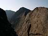
Horseshoe Mountain and the impressive cirque it towers over come into view at this point. Turn southeast and head along the ridgeline toward Pt. 10,982. Exposure along this section of the west ridge is great to the east but slim on the western side.
Either climb up and over Pt. 10,982 or contour around it on the west using goat paths, and head for the final stretch of Horseshoe Mountain.
At 11,200' the ridge turns east and heads across by far the most dangerous section of the route. The ridge at this point is blocked by three difficult, horribly rotten scrambling sections. Bypassing these cliffs on either side is out of the question because of the dangerously steep scree slopes that lay below.
The first climbing section begins immediately. The ridge is blocked by a small cliff tower that is characterized by having a small, impassable passage in between two large boulders. This terrain would be class III if it were on stable rock, however, this is some of the most rotten terrain in the west and therefore the difficulty is class 4.
Drop to the northern side of the two boulders that form the passage to re-gain the ridge as soon as possible. Watching every footstep with great care, follow the ridgeline down about 20 feet to the next obstacle.
Climb, relatively easily, up and over the second small tower to reach the most difficult of the three.
At this point it is pertinent not to drop to either side of the ridgeline, the terrain here is frightening.
Climb up the third small tower to the top where there is 6-8 foot drop to the ridge below. Down climb this like a ladder securing every foothold by kicking out the numerous loose rock on the wall. Landing is the scariest part.
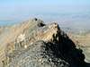
The ridge thins to a sharp, knife edge for the next few dozen yards. It is best to do this more of a crawl than walk staying as close to the crest as possible.
The last few hundred feet to the summit are a relief as the terrain changes to an enjoyable ridge walk. On the summit enjoy fantastic views of Borah Peak's north face.
On the descent, the third obstacle is easier while the first is much more difficult.
 |  |  |  |  |
Red Tape
No red tape or permits required here.The fossils that are aforementioned in the overview section are quite special and delicate, please do not disturb them.
 |
When To Climb
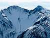
Snow would greatly affect the difficulty of summiting Horseshoe Mountain, making it nearly impossible because of exposure and great avalanche danger.A snow-free climb is possible most years from late-July through mid-October.
Camping
The steep nature of this terrain would make it difficult to find camping along the route. There are no nearby campgrounds either. Car or tent camping at the base would be nightmare due to the numerous cattle in the area and moderates amout of traffic that travel along Doublespring Pass Road.Horseshoe Mountain would best be summited as a day trip from either Arco or Sun Valley.
Mountain Conditions
Again, this mountain is quite remote and very little in the way of weather observations can be found.The NOAA Pinpoint Forecast most likely has the best weather analysis for the area. Also, for a recent update of field reports, check out the Idaho Outdoors Forum.