-
 9068 Hits
-
 86.85% Score
-
 23 Votes
|
|
Mountain/Rock |
|---|---|
|
|
44.17771°N / 113.80051°W |
|
|
Custer |
|
|
Hiking, Mountaineering, Mixed, Scrambling |
|
|
Spring, Summer, Fall, Winter |
|
|
11310 ft / 3447 m |
|
|
Overview
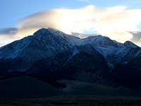
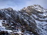
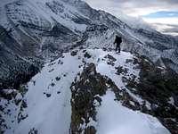
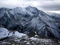
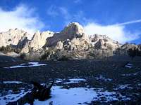
Of all Lost River Range peaks, Al West Peak has perhaps the best view of the North Face of Borah Peak. With it's relatively lower elevation and it's proximity to Borah and other nearby 12er's, Al West sees few visits to it's summit. As of December 2006, only 3 other parties had signed the register tin since 1990. Al West Peak is one of the northernmost mountains in the Lost River Range and sits just 2.9 miles NNW of Borah, 2.6 miles NW of Mountaineer Peak, and just 0.8 miles SSE of Horseshoe Mountain. When access to some of the taller peaks is limited, Al West can often be climbed nearly year round. Combined with Horseshoe Mountain, and DoubleSprings Peak to the north, an interesting ridge traversed can be done in a day or less.
Al West gets it's unofficial name from an early homesteader in the area that often assisted the earliest climbers and surveyors in their exploration of nearby Borah. His home at the base of the peak was used as a triangulation point by early surveyors and his life was full of adventure, survival, and subsistence. Legend has it that he rode a horse from Idaho to Chicago for the 1893 World's Fair. Today, there is little physical evidence of his occupation in the area, but in the 1900's a dam and irrigation project was created up the Rock Creek Drainage on the southwest side of Al West Peak. Common for it's time, this water project help irrigate the Thousand Springs Valley below. Today, there are pieces of the pipes and support structures everywhere along the Rock Creek approach.
Routes
The Southeast Ridge- See the Routes Page for more information. Other route possibility exists, especially if combining peaks or ridge running.
Getting There
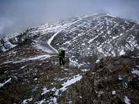
Follow ID-93 22.6 miles north of Mackay, Idaho and turn right onto DoubleSprings Pass Road. Follow this road for ~1.4 miles and turn right onto Rock Creek Road. Follow this dirt road ~2.3 miles to the dam at the mouth of the canyon. Park here and start. There are many connecting roads in the area, so other possibilities may exist. In winter, ID-93 is usually kept in good shape. DoubleSprings Pass Road is usually passable even without 4WD in good weather. Rock Springs Road may require 4WD, particularly in winter.
Check the road conditions at: Idaho Transportation Department
Conditions and Season
Conditions may vary greatly. There are periods of very dry and cold weather in the winter.
Nearby Mackay, Idaho Climate Data:
| Jan | Feb | Mar | Apr | May | Jun | Jul | Aug | Sep | Oct | Nov | Dec | Annual | |
| Average Max. Temperature (F) | 29.2 | 34.2 | 43.0 | 55.2 | 65.2 | 74.1 | 84.1 | 82.7 | 73.3 | 60.1 | 42.1 | 31.3 | 56.2 |
| Average Min. Temperature (F) | 5.6 | 10.1 | 18.9 | 28.1 | 35.9 | 42.3 | 48.4 | 46.3 | 38.3 | 30.0 | 18.7 | 8.9 | 27.6 |
| Average Total Precipitation (in.) | 0.78 | 0.61 | 0.61 | 0.68 | 1.09 | 1.34 | 0.93 | 0.80 | 0.67 | 0.57 | 0.59 | 0.78 | 9.43 |
| Average Total SnowFall (in.) | 7.5 | 5.9 | 2.4 | 0.5 | 0.1 | 0.0 | 0.0 | 0.0 | 0.1 | 0.2 | 2.0 | 7.3 | 26.1 |
| Average Snow Depth (in.) | 5 | 4 | 1 | 0 | 0 | 0 | 0 | 0 | 0 | 0 | 0 | 3 | 1 |
For general comparison, the Lost River Valley is much drier (climatologically a desert) in the winter than some of the ranges to the west in Idaho. Yet in the summer, the Lost River Valley receives more precipitation. Periods of dry, cold, and windy weather may give opportunities to climb nearly year round.

Salmon-Challis National Forest Info
http://www.fs.fed.us/r4/sc/lostriver/maptravelplanaerialphotos.shtml
National Weather Service Current Forecast for Mackay:
http://newweb.wrh.noaa.gov/total_forecast/index.php?zone=idz032&county=idc037&wfo=pih&dgtl=1&lat=43.91472&lon=-113.6125