
-
 6842 Hits
-
 82.48% Score
-
 15 Votes
|
|
Mountain/Rock |
|---|---|
|
|
43.99290°N / 113.5378°W |
|
|
Custer |
|
|
Hiking, Mountaineering, Scrambling, Skiing |
|
|
Spring, Summer, Fall, Winter |
|
|
11309 ft / 3447 m |
|
|
Overview
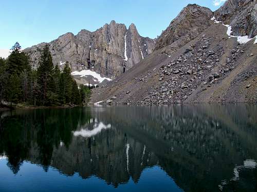
Location: South-South Eastern part of the range, typically accessed from Pass Creek Road. Sits at the head of a large alpine basin as the tallest peak in the immediate vicinity. Could also be accessed from upper Lower Cedar Creek.
Nearby Peaks: Octoberfest Peak, Hidden Peak, South Wet (Pinhead's Revenge), USGS, Warren Mountain, Sheephead Mountain
Linkups: Warren Mountain, Octoberfest Peak, Hidden Peak, South Wet
Difficulty: Class 2-3 from SE / Class 3 from North
Usage: Hiking, Skiing, Scrambling, Scientific Experimentation
Terrain: Relatively solid scree and talus above broad and open high altitude meadows. Ridge is long and broad with steep east face drop off and gentle west slope. North ridge is rocky and steep.
Traffic: Very light traffic. The taller 12's of the region see most of the traffic. If you saw another party here, it would be unusual. This peak is often done as a multi peak traverse with Octoberfest and Hidden.
Summit Register: Yes.(60th tallest mountain in Idaho)
History / Entomology: Named for the triangulation station listed on the USGS map (remnants remain).
Getting There
Nearest Paved Roads: ID-93
Nearest Dirt Roads / Conditions: Pass Creek Road (good), Bear Creek CG Road (rough)- To reach the end of the road may require 4WD, otherwise a sedan could park 0.75 miles from TH.
Approach Trails / Conditions: Bear Creek Trail (good)

Routes
Main Route: Bear Creek Trail to the Bear Creek Lake trail. Once at the Lake contour around the lake (east) and head north up a narrowing drainage. At the Octoberfest-Hidden saddle, follow the open basin to either the saddle between Wet and South Wet or the saddle between Hidden and Wet. The north ridge presents more route finding and steeper scrambling. The southeast ridge is an easy walk up.
Descent: Retrace your steps.
Main Route Stats: 11 miles / 4851 (round trip) / 16% Average Grade
Average RT Time: 4-6 hours
Traverse Route: Follow the Bear Creek Trail to the pass between Warren and Octoberfest. Follow the ridge to Warren Mountain, retrace steps and follow the broad ridge west, then north onto Octoberfest (Class 2). From Octoberfest, drop to the saddle with Hidden. Either gain Hidden's northeast ridge from the basin (Class 3), or use the southeast ridge (Class 3). From Hidden, descend to the saddle with Wet. Climb the north ridge (Class 3). Depending on exact route and snow, this section could go Class 3-4. From Wet, follow the broad ridge south to the obvious saddle with South Wet. There's a hydrological container of some type at this saddle. Climb the north slopes to South Wet (Class 2).
Descent: Follow the scenic ridge northeast to the upper Bear Creek Basin (Hidden-Octoberfest saddle).
Main Route Stats: 15.1miles / 8095 (round trip) / 8% Average Grade
Average RT Time: 9-12 hours

Red Tape
Jurisdiction: National Forest (Challis National Recreation Area)
Permit: No
Other Users / Issues: Pack Animals
Maps: USGS Quad- Massacre Mtn, Mackay
Guide Book: Tom Lopez, Idaho: A Climbing Guide,

When to Climb
Climbing Season: Summer, Fall (June-Dec)
Ideal Climbing Time: June-Oct
Nearest Weather Station: Mackay
Weather Relative to Region: located in the southern part of the range and overshadowed by the larger peaks, this area sees less precipitation and melts out earlier. Like much of the Lost River Range, you can often climb with little snow until Dec or Jan. From Mar-May, the area receives the bulk of it's snow. Winds are usually strong on the ridges.

Camping
Car Camping Sites: Bear Creek Campground areas offer lots of drive in camp sites plus many primitive sites along Pass Creek Road.
Backpacking Sites: Bear Creek Lake or the upper basin are ideal sites

Flora & Fauna
Potential Wildlife: Badger, Beaver, Black Bear, Mule Deer, Pronghorn, Cougar, Coyote, Elk, Marmot, Marten, Moose, Mountain Goat, Pika,
Confirmed Wildlife: Pika, Elk, Mule Deer, Mountain Goat
Vegetation: Stinging Nettles, Willow, Berry Brush, Pine (little vegetation above 8600 ft)


