
-
 11136 Hits
-
 87.31% Score
-
 24 Votes
|
|
Mountain/Rock |
|---|---|
|
|
43.99530°N / 113.611°W |
|
|
11071 ft / 3374 m |
|
|
Overview
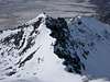
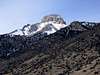
Often overshadowed by it's impressive older brother, Mt. McCaleb, Little Mac rises above 11,000 feet and offers steep scrambling. The seldom seen (access is from the upper reaches of Upper Cedar Creek) vertical north face of Little Mac is longer than Mt. McCaleb's impressive south summit wall. The two peaks are easily done together- there is a major saddle at 10,600 feet between them. Situated at the southern end of the Lost River Range, Little Mac and Mt. McCaleb are some of the first of the larger peaks that you'll notice when driving north from Arco. The Lost River Range is a relatively dry mountain range. By the time the prevailing storm tracks reach this area, they would have crossed the dry Oregon or Nevada Desert. Storms from the west must pass through the Boise Mountains, The Sawtooths, The White Clouds, The Boulder, and the Pioneer Mountains before reaching the Lost River Range. Storms usually have little snow left to dump on these mountains. And what snow falls is so powdery from the extreme cold and dryness, that it often blows off the nearby mountains. This presents nice winter opportunities for climbers. For example, this author summitted Little Mac and McCaleb in the third week of December and encountered only patchy snow and 50% rock. Like all climates there are exceptions and these mountains can get dumped on.
Here are the routes on Little Mac:
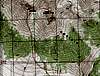
1) South Ridge (Class 3) - From the southern base of the mountains, at the end of the Jeep roads, follow the prominent gulley that runs between Little Mac and McCaleb. Stay left of the gulley from 8000 feet. At 9200 feet you'll reach a nice knoll with great views of McCaleb. Follow the steep prominent ridge slightly to your left up the prominent south ridge of Little Mac. After a very steep initial ascent, a few easy rock towers and cornice crossings lead you to the summit. Continue east down to the saddle if you plan to climb McCaleb.
Total Distance / Elevation gain from end of Jeep roads: 3.25 miles / 5000 feet (Red route on the topo map)
2) Gulley Route (Class2-3) - At the prominent knoll at 9200 feet, follow the major drainage north between the peaks on pure boulders and rock scree (no large vegetation after 9200 ft) until you reach the prominent saddle at 10,600 feet. From here climb the east ridge up to Little Mac.
Total Distance / Elevation gain from end of Jeep roads: 3.25 miles / 4950 feet (Green route on the topo map)
The north side of the peak has huge rock and snow climb potential.
 |  |  |  |
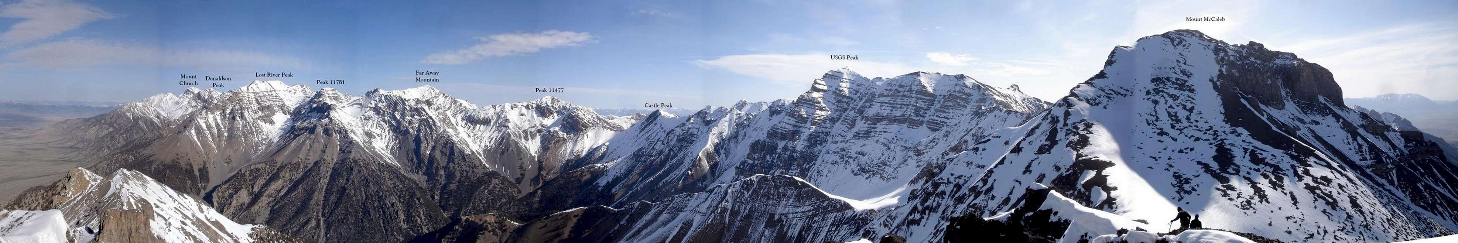
Summit Panorama
  |
Getting There
Road ApproachFrom Highway 93 in Mackay, turn northeast near the center of town and drive for 2.1 miles on Bench Road. You'll bear right at the Mt. McCaleb Cemetery Go left onto Cedar Creek Road and follow a drainage ditch until your near the opening of the canyon (3.7 miles). Bear left (east) along the base of the hill and look for one of a few Jeep roads. Follow the roads as high as you are comfortable with. (We parked a Jeep Grand Cherokee at 7500 feet in December- It's possible to park as high as 8100 feet)
Note- If you drive from Boise, you will pass Craters of the Moon NP: http://www.id.blm.gov/craters/
Hiking Approach
Follow the prominent drainage gulley coming down from between the peaks. Use shortcuts at your own risk- you could get cliffed. Once at 9200 feet, it's wide open and obvious.
 |  |  |  |  |
When To Climb
Standard climbing season is April through November Conditions may vary greatly. There are periods of very dry and cold weather in the winter.Nearby Mackay, Idaho Climate Data:
| Jan | Feb | Mar | Apr | May | Jun | Jul | Aug | Sep | Oct | Nov | Dec | Annual | |
| Average Max. Temperature (F) | 29.2 | 34.2 | 43.0 | 55.2 | 65.2 | 74.1 | 84.1 | 82.7 | 73.3 | 60.1 | 42.1 | 31.3 | 56.2 |
| Average Min. Temperature (F) | 5.6 | 10.1 | 18.9 | 28.1 | 35.9 | 42.3 | 48.4 | 46.3 | 38.3 | 30.0 | 18.7 | 8.9 | 27.6 |
| Average Total Precipitation (in.) | 0.78 | 0.61 | 0.61 | 0.68 | 1.09 | 1.34 | 0.93 | 0.80 | 0.67 | 0.57 | 0.59 | 0.78 | 9.43 |
| Average Total SnowFall (in.) | 7.5 | 5.9 | 2.4 | 0.5 | 0.1 | 0.0 | 0.0 | 0.0 | 0.1 | 0.2 | 2.0 | 7.3 | 26.1 |
| Average Snow Depth (in.) | 5 | 4 | 1 | 0 | 0 | 0 | 0 | 0 | 0 | 0 | 0 | 3 | 1 |
For general comparison, the Lost River Valley is much drier (climatologically a desert) in the winter than the Sawtooth Valley. Yet in the summer, the Lost River Valley receives more precipitation. It is quite warmer in the Lost River Valley than the Sawtooth Valley, especially in October.
 |  |  |
Mountain Conditions

Latest Avalanche Report (Sawtooth Area, yet it still can be useful)
http://www.avalanche.org/~svavctr/
Salmon-Challis National Forest Info
http://www.fs.fed.us/r4/sc/lostriver/maptravelplanaerialphotos.shtml
National Weather Service Current Forecast for Mackay:
http://newweb.wrh.noaa.gov/total_forecast/index.php?zone=idz032&county=idc037&wfo=pih&dgtl=1&lat=43.91472&lon=-113.6125 Red Tape
There are no hiking, backpacking or parking regulations or fees.
Camping
Camping- There are many drive-in camp sites at Mackay Reservoir
- You could camp near where you park- camping would be difficult higher on the mountain. Water sources are scarce.
External Links
- Sawtooth Avalanche Report
Avalanche Report
- Salmon Challis National Forest Link
Salmon Challis National Forest Link
- NWS Forecast
Mackay area forecast
- Craters of the Moon
On your way to the Lost River Range
- Sawtooth Avalanche Report