
-
 5290 Hits
-
 83.1% Score
-
 16 Votes
|
|
Mountain/Rock |
|---|---|
|
|
41.81534°N / 9.24877°E |
|
|
Bavedda, Bavella |
|
|
Sport Climbing |
|
|
Spring, Fall |
|
|
2953 ft / 900 m |
|
|
Overview
Geographical classification: Corsica - Corse > Bavella Massif > Punta di Rinaghju
Punta di Rinaghju
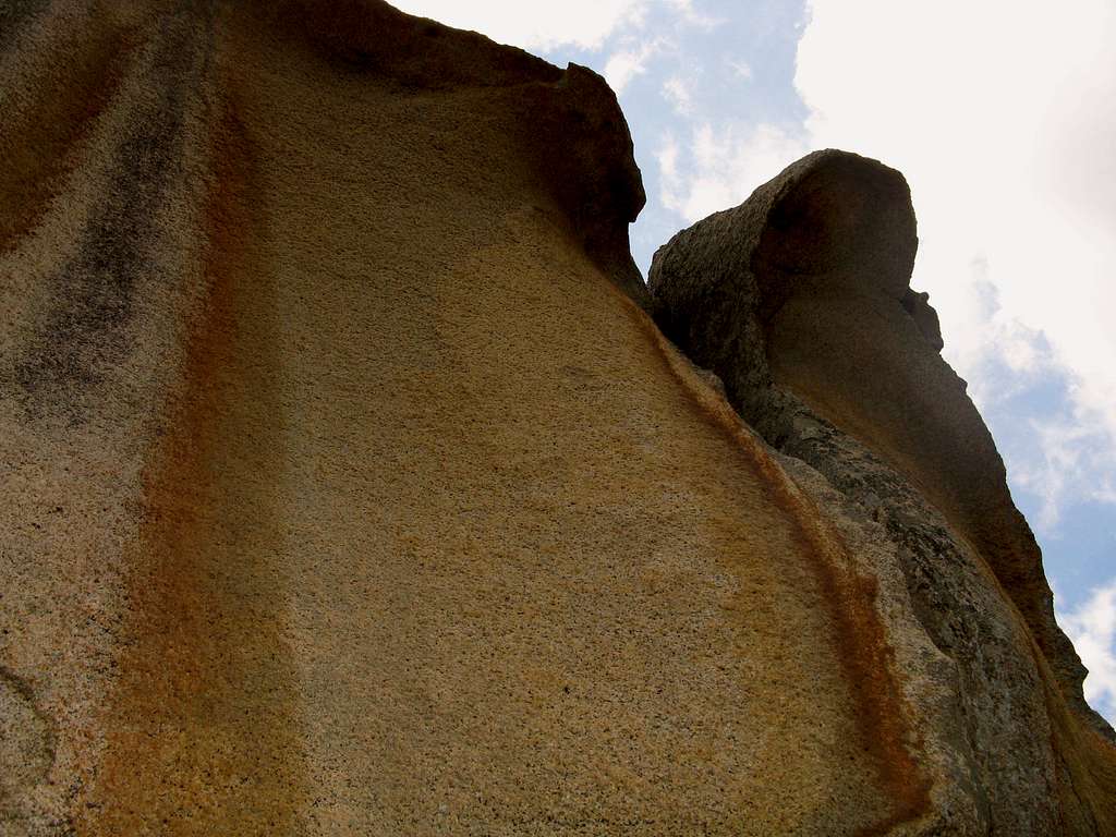
Punta di Rinaghju is a reddish tower in the shape of a “totem”, a minor summit overlooking the right-hand side of road D268 Solenzara – Col de Bavella, when you’re following it from Solenzara to the pass. The tower is not showy, but its South Face is an incredible rocky building, extraordinarily carved, with high quality “Bavellian” granite. A very fine route - seeming more difficult then it really is - had been realized on this face.
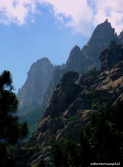
The totem of Punta Rinaghju |
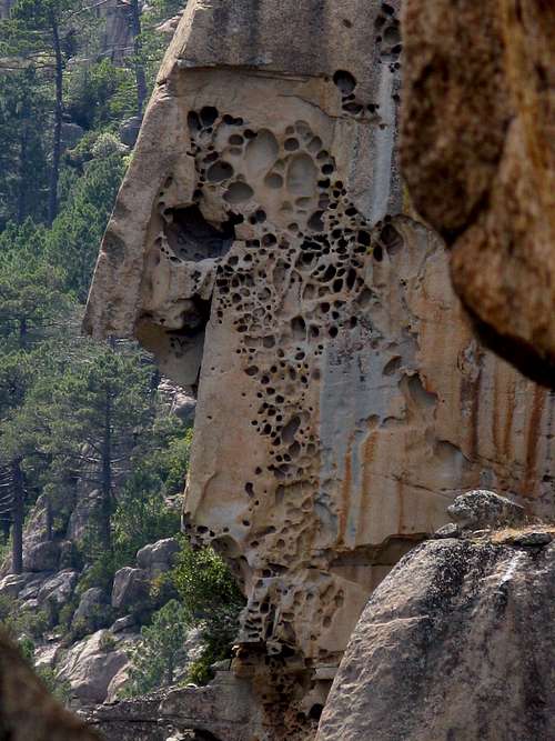
Amazing "tafoni" |
Getting There
ROAD ACCESS TO BAVELLA PASS
- From Bastia (Corsica eastern coast) follow the road RN 198 to Solenzara; less then 1 km. before Solenzara turn to right and follow the road D268 to Bavella Pass (km. 130 from Bastia). About 10 km. before reaching the col park the car in a pull-out nearby the Rinaghju Bridge.
- From Aiaccio (Corsica western coast) follow the road RN 196 to Petreto, then the road N852 to Aullene, Quenza and Zonza (km. 90 from Aiaccio). From Zonza follow the road D268 to Col de Bavella.
FROM BAVELLA PASS TO THE CLIFF
The cliff is situated on the left along the NE side of the road D268 nearby the Rinaghju Bridge (Renaju IGN) between Col de Bavella and Bocca di Larone. Froma Bavella Pass follow down the road D268 along the NE side towards Solenzara for about 10 km., reaching the Rinaghju Bridge. After the bridge look for the road-sign “Aire de regroupement en cas d’incendie”. Park the car in a pull-out. From here the track to the cliff is starting.
WALKING APPROACH TO THE CLIFF From the road-sign “Aire de regroupement en cas d’incendie” follow the trail, really not very obvious in the beginning. After 50 mt. - nearby a huge block - turn to right then immediately to left, reaching a steep slope with blocks. Follow the stony ground, then enter again inside the wood and follow the trail with some little “cairns”, leading to a rocky gully with a fixed rope. Climb the gully reaching a little tree. From the tree don’t follow the second fixed rope heading towards left and starting here, but continue up towards right, reaching a big cairn. From here look for another fixed rope inside the wood. Follow the fixed rope leading out from the wood and reach some easy slabs below a very fine reddish face, extraordinarily carved with magnificent “tafoni” (30 minutes from the parking).
La Danse du Scalp report route
LA DANSE DU SCALP
Summit altitude: about 970 m
Difficulty: TD, 7a (a single move), 6a+ obbl., equipped with bolts
Length: 150 m
Exposure: SE First ascent: C. Ascensao - X. Legendre 2002
Approach starting: Road D268 Col de Bavella near Renaju Bridge
Huts: Gite d’Etape “du Col de Bavella”, Gite d’Etape “Les Aiguilles de Bavella”

|

|
"LA DANSE DU SCALP" REPORT (French Scale)
A fine sustained route with pure “bavellian” orange granite. The route’s name is inspired to the tower’s shape, looking like a “totem”.
L1 – Climb some little shallows corner below an overhang, then climb the overhang on its left-hand side (a short 6c move, 6a obbl.). Slantways towards left climb a superb succession of red “tafoni”, then slant towards right to a stance below a sloping slab. 6a+, a short 6c move not obligatory.
L2- Climb the slab along its “tafonated” left edge heading to a characterstic reddish beak and reaching the belay inside a wonderful orange ogive. 6a.
L3 – Climb the “tafoni” to go out of the ogive, then a smooth slab – a short 7a move, 6a obbl.; after the slab climb a technical shallow corner reaching a belay under a juniper. 6a+, a short 7a move.
L4 – Up along a short steep wall, reaching a vegetated ledge. Another cracked wall leads to the belay, situated nearby a huge “tafonated” cave. 5c.
L5 - Follow a ridge with some little overhangs leading to the top of the “totem”. 6a

Descent: rapping on the route with 5 abseils.
Red tape
Bavella Massif is really a fantastic world, a preserved milieu situated inside a Regional Park, the Parc Naturel Régional de Corse - Parcu di Corsica. Free camping and bivouac are not allowed. Fires are strictly forbidden. Maximum care is required to keep for the future this extraordinary environment.
Nature and climate
Bavedda nature is wild and peculiar and the granite is often exceptionally carved. In Corsica we can find more than 5% of authoctonous kinds of flowers and plants, in addition to the authoctonous fauna. On the contrary several kinds of animals current inside Mediterranean countries are away from Corsica, like squirrels and vipers.

|
")
|
Climate is the typical one of the mediterranean middle-mountain areas lying on these latitudes: often very hot in summer and with cold and snowy winters; early and middle Spring and Fall are the better seasons to climb. Due to Bavella closeness to the sea, winds are often stronger how much they are at the same height in the Alps.
Where to stay

COL DE BAVELLA
Auberge du Col de Bavella - Hotel and Gite d’Etape
Gite d'Etape Les Aiguilles de Bavella
ZONZA Hotel L’Aiglon, Hotel de la Terrasse
Equipped Campings: Municipal Camping of Zonza, Camping La Riviere
When to climb
Due to its limited height and its SE exposition, the cliff is sometimes hot in summer. Best seasons to climb are Spring and Fall.
Meteo
Guidebooks and maps
 |
 |
“Bavedda – Aiguilles entre ciel et torrents: Escalade, Rando, Canyon” by Jean Louis Fenouil and Jean Paul Quilici - FFME
“Acqua e Petra – Canyons et Escalades en Corse du Sud” by Jean Paul Quilici and Francis Thibaudeau
Map IGN 4253 ET “Aiguilles de Bavella – Solenzara”